Kakeromajima
加計呂麻島, Kakeroma Island, Île Kakeroma
28°08′N 129°14′E
Kakeromajima (Japanese: 加計呂麻島; also Kakeroma-tō; Amami: Xakeroma) is one of the Satsunan Islands, classed with the Amami archipelago between Kyūshū and Okinawa.
Terrain
28°08′N 129°14′E
Overview
Kakeromajima (Japanese: 加計呂麻島; also Kakeroma-tō; Amami: Xakeroma) is one of the Satsunan Islands, classed with the Amami archipelago between Kyūshū and Okinawa. The island, 77.39 km2 (29.88 sq mi) in area, has a population of approximately 1,600 persons. Administratively it is part of the town of Setouchi in Kagoshima Prefecture. Much of the island is within the borders of the Amami Guntō Quasi-National Park.
From Wikipedia, CC BY-SA 4.0
Chart
Nearest islands
- Uke Island11 km
- Yoroshima14 km
- Edateku Island18 km
- Amami Ōshima26 km
- Tokunoshima48 km
- Kikai Island76 km
Also in Amami Islands

Amami Ōshima
712 km²▲ 694 m
Major islands

Tokunoshima
248 km²▲ 645 m
Major islands

Okinoerabujima
93.5 km²▲ 240 m
Major islands

Kikai Island
56.9 km²▲ 63 m
Minor islands

Yoronjima
20.6 km²▲ 99 m
Minor islands

Uke Island
13.3 km²▲ 398 m
Minor islands

Yoroshima
9.4 km²▲ 230 m
Minor islands

Edateku Island
5.8 km²▲ 322 m
Minor islands
Also in Satsunan Islands
Amami Ōshima
712 km²▲ 694 m
Major islands

Yakushima
504 km²▲ 1,936 m
Major islands

Tanegashima
445 km²▲ 238 m
Major islands
Tokunoshima
248 km²▲ 645 m
Major islands
Okinoerabujima
93.5 km²▲ 240 m
Minor islands
Kikai Island
56.9 km²▲ 63 m
Minor islands

Kuchinoerabu Island
35.8 km²▲ 649 m
Minor islands

Nakanoshima
34.4 km²▲ 979 m
Minor islands
Also in Ryukyu Islands

Okinawa Island
1,207 km²▲ 503 m
Major islands
Amami Ōshima
712 km²▲ 694 m
Major islands
Yakushima
504 km²▲ 1,936 m
Major islands
Tanegashima
445 km²▲ 238 m
Major islands

Iriomote Island
290 km²▲ 470 m
Major islands
Tokunoshima
248 km²▲ 645 m
Major islands

Ishigaki Island
223 km²▲ 526 m
Major islands

Miyako Island
159 km²▲ 109 m
Major islands
Also in Ryukyu Arc
Okinawa Island
1,207 km²▲ 503 m
Major islands
Amami Ōshima
712 km²▲ 694 m
Major islands
Yakushima
504 km²▲ 1,936 m
Major islands
Tanegashima
445 km²▲ 238 m
Major islands
Iriomote Island
290 km²▲ 470 m
Major islands
Tokunoshima
248 km²▲ 645 m
Major islands
Ishigaki Island
223 km²▲ 526 m
Major islands
Miyako Island
159 km²▲ 109 m
Major islands
Also in Japanese archipelago
Japan
377,974 km²
Major islands

Honshu
227,970 km²▲ 3,776 m
Major islands

Hokkaido
77,983 km²▲ 2,291 m
Major islands

Kyushu
36,770 km²▲ 1,791 m
Minor islands

Shikoku
18,284 km²▲ 1,982 m
Minor islands
Okinawa Island
1,207 km²▲ 503 m
Minor islands
Amami Ōshima
712 km²▲ 694 m
Minor islands
Shimoshima Island
575 km²▲ 538 m
Minor islands
Also in Pacific Islands

New Guinea
774,566 km²▲ 4,884 m
Major islands
Japan
377,974 km²
Major islands
New Zealand
268,021 km²
Major islands
Honshu
227,970 km²▲ 3,776 m
Major islands

Luzon
104,935 km²▲ 2,928 m
Major islands

Mindanao
93,885 km²▲ 2,954 m
Major islands
Hokkaido
77,983 km²▲ 2,291 m
Minor islands

Sakhalin
74,571 km²▲ 1,609 m
Minor islands
Photographs

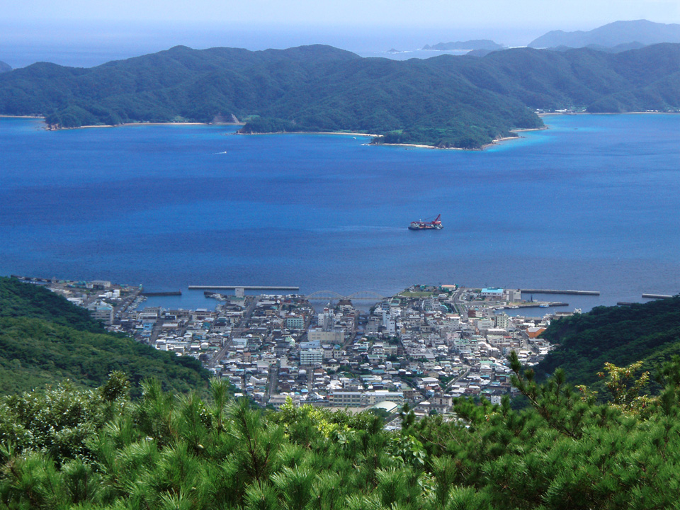
View of Koniya from Kochi-yama(Mt.Kochi-yama) observation deck in Setouchi-cho, Ohshima-gun, Kagoshima-ken, Japan. View with Ohshima-kaikyo(Ohshima Straits) and part of Kakeroma-jima(Island of Kakeroma), too.

加計呂麻島で寅さんと浅岡ルリ子が暮らしたリリーの家

瀬戸内町立俵中学校

瀬戸内町立伊子茂小学校・伊子茂中学校

瀬戸内町立諸鈍小学校・諸鈍中学校

諸鈍郵便局(瀬戸内町諸鈍)

大屯神社(おおちょんじんじゃ、瀬戸内町諸鈍繰原)

押角郵便局(瀬戸内町押角)

大屯神社(おおちょんじんじゃ、瀬戸内町諸鈍繰原)

加計呂麻島の呑ノ浦にある特攻艇震洋基地跡 ???

野見山にある高倉

瀬戸内警察署 俵駐在所(瀬戸内町大字俵)
Sources
Facts
Photographs
- View of Koniya from Kochi-yama. 岩元剛 Tsuyoshi Iwamoto / CC BY 3.0
- 129加計呂麻島リリーの家. Kireinakokoro / CC BY-SA 4.0
- Setouchi Town Hyou Lower secondary school. Suikotei / CC BY-SA 4.0
- Setouchi Town Ikomo Elementary & Lower secondary school. Suikotei / CC BY-SA 4.0
- Setouchi Town Syodon Elementary & Lower secondary school. Suikotei / CC BY-SA 4.0
- Syodon Post office. Suikotei / CC BY-SA 4.0
- Oochon jinja. Suikotei / CC BY-SA 4.0
- Oshikaku Post office. Suikotei / CC BY-SA 4.0
- Oochon jinja Torii. Suikotei / CC BY-SA 4.0
- Shinyo at Kakeromajima. Suikotei / CC BY-SA 4.0
- Takakura at Nomiyama, Kakeroma. Suikotei / CC BY-SA 4.0
- Setouchi Police Station Hyou Residential Police Box. Suikotei / CC BY-SA 4.0