Okinawa Island
沖縄本島, Okinawa, Okinawa Hontō
26°28′N 127°55′E
Okinawa Island (Japanese: 沖縄島, Hepburn: Okinawa-jima; Okinawan: 沖縄 / うちなー, romanized: Uchinā; Kunigami: ふちなー, romanized: Fuchináa), also known as Okinawa Main Island (沖縄本島, Okinawa-hontō), is the largest of the Okinawa Islands and the Ryukyu (Nansei) Islands of Japan in the Kyushu region. 02 sq mi).

Terrain
26°28′N 127°55′E
Overview
Okinawa Island (Japanese: 沖縄島, Hepburn: Okinawa-jima; Okinawan: 沖縄 / うちなー, romanized: Uchinā; Kunigami: ふちなー, romanized: Fuchináa), also known as Okinawa Main Island (沖縄本島, Okinawa-hontō), is the largest of the Okinawa Islands and the Ryukyu (Nansei) Islands of Japan in the Kyushu region. The island is approximately 106 kilometres (66 mi) long, an average 11 kilometres (7 mi) wide, and has an area of 1,206.98 square kilometers (466.02 sq mi). It is roughly 640 kilometres (350 nmi; 400 mi) south of the main island of Kyushu and the rest of Japan. It is 500 km (270 nmi; 310 mi) northeast of Taiwan. The total population of Okinawa Island was 1,384,762 in 2009. The greater Naha area has roughly 800,000 residents, while the city itself has about 320,000 people. Naha is the seat of Okinawa Prefecture on the southwestern part of Okinawa Island. Okinawa has a humid subtropical climate. Okinawa has been a strategic location for the United States Armed Forces since the Battle of Okinawa and the end of World War II. The island was formally controlled by the United States Civil Administration of the Ryukyu Islands until 1972, with around 26,000 U.S. military personnel stationed on Okinawa today, comprising about half of the total complement of the United States Forces Japan, spread among 31 areas, across 13 bases and 48 training sites. United States military installations cover approximately 25% of the island and have been a point of contention among locals. Crimes committed by US military personnel, notably the 1995 Okinawa rape incident, have caused protests against the US military presence in Okinawa.
From Wikipedia, CC BY-SA 4.0
Chart
Nearest islands
- Yagaji Island23 km
- Iejima29 km
- Izena Island51 km
- Kerama Islands60 km
- Tokashiki Island63 km
- Iheya Island65 km
Also in Okinawa Islands

Kume Island
59.6 km²▲ 310 m
Major islands

Kerama Islands
0.49 km²▲ 106 m
Major islands

Iejima
22.8 km²▲ 172 m
Minor islands

Iheya Island
20.7 km²▲ 294 m
Minor islands

Tokashiki Island
15.3 km²▲ 226 m
Minor islands

Izena Island
14.2 km²▲ 121 m
Minor islands

Yagaji Island
7.8 km²▲ 58 m
Minor islands

Aguni Island
7.6 km²▲ 96 m
Minor islands
Also in Ryukyu Islands

Amami Ōshima
712 km²▲ 694 m
Major islands

Yakushima
504 km²▲ 1,936 m
Major islands

Tanegashima
445 km²▲ 238 m
Major islands

Iriomote Island
290 km²▲ 470 m
Major islands

Tokunoshima
248 km²▲ 645 m
Major islands

Ishigaki Island
223 km²▲ 526 m
Major islands

Miyako Island
159 km²▲ 109 m
Major islands

Okinoerabujima
93.5 km²▲ 240 m
Minor islands
Also in Ryukyu Arc
Amami Ōshima
712 km²▲ 694 m
Major islands
Yakushima
504 km²▲ 1,936 m
Major islands
Tanegashima
445 km²▲ 238 m
Major islands
Iriomote Island
290 km²▲ 470 m
Major islands
Tokunoshima
248 km²▲ 645 m
Major islands
Ishigaki Island
223 km²▲ 526 m
Major islands
Miyako Island
159 km²▲ 109 m
Major islands
Okinoerabujima
93.5 km²▲ 240 m
Minor islands
Also in Japanese archipelago
Japan
377,974 km²
Major islands

Honshu
227,970 km²▲ 3,776 m
Major islands

Hokkaido
77,983 km²▲ 2,291 m
Major islands

Kyushu
36,770 km²▲ 1,791 m
Minor islands

Shikoku
18,284 km²▲ 1,982 m
Minor islands
Amami Ōshima
712 km²▲ 694 m
Minor islands
Shimoshima Island
575 km²▲ 538 m
Minor islands
Yakushima
504 km²▲ 1,936 m
Minor islands
Also in Pacific Islands

New Guinea
774,566 km²▲ 4,884 m
Major islands
Japan
377,974 km²
Major islands
New Zealand
268,021 km²
Major islands
Honshu
227,970 km²▲ 3,776 m
Major islands

Luzon
104,935 km²▲ 2,928 m
Major islands

Mindanao
93,885 km²▲ 2,954 m
Major islands
Hokkaido
77,983 km²▲ 2,291 m
Minor islands

Sakhalin
74,571 km²▲ 1,609 m
Minor islands
Photographs

Daisekirinzan at Yanbaru National Park. Daisekirinzan is a subtropical forest national park with trails & unusual rock formations, plus a visitor center in the northern Kunigami, Okinawa.
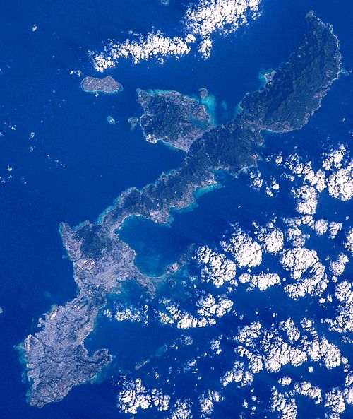
Okinawa Island, Okinawa Prefecture, Japan.


JP 沖繩 Okinawa 名護 Nago Paanilani Hawaiian Pacakes House 日本 698 Serakaki, Onna, Kunigami District, Okinawa 904-0404 January 2026 N13P 01

JP 沖繩 Okinawa 名護 Nago Paanilani Hawaiian Pacakes House 日本 698 Serakaki, Onna, Kunigami District, Okinawa 904-0404 January 2026 N13P 01

Kanna Reservoir in Okinawa, Japan

Kannafukuji River of Okinawa, Japan

Igei Service Area, a rest area for inbound of the Okinawa Expressway, Kin Town, Okinawa Prefecture, Japan

Pinus luchuensis, Okinawa, Japan

Pinus luchuensis, Okinawa, Japan

Okinawa Green Tree Frog (Zhangixalus viridis) in Japan

Okinawa Green Tree Frog (Zhangixalus viridis) in Japan
Sources
Facts
Photographs
- Daisekirinzan at Yanbaru National Park Okinawa 2008. Ryan McBride / CC BY 2.0
- Okinawa Island-ISS042. Image Science and Analysis Laboratory, NASA - Johnson Space Center. "The Gateway to Astronaut Photography of Earth." / Public domain
- MC-130J Commando IIs from the 1st Special Operations Squadron off the coast of Okinawa. Airman 1st Class Stephen Pulter / Public domain
- JP 沖繩 Okinawa 名護 Nago Paanilani Hawaiian Pacakes House 日本 698 Serakaki, Onna, Kunigami District, Okinawa 904-0404 January 2026 N13P 03. NORTLAUKAU 26088 JP / CC0
- JP 沖繩 Okinawa 名護 Nago Paanilani Hawaiian Pacakes House 日本 698 Serakaki, Onna, Kunigami District, Okinawa 904-0404 January 2026 N13P 05. NORTLAUKAU 26088 JP / CC0
- Kanna Reservoir. Ray_go / CC BY-SA 3.0
- Kannafukuji River. Ray_go / CC BY-SA 3.0
- 沖縄のSA - panoramio. funk bass / CC BY 3.0
- Pinus luchuensis, Okinawa, Japan 01. re_nebel / CC BY 4.0
- Pinus luchuensis, Okinawa, Japan 02. pelser / CC BY 4.0
- Zhangixalus viridis 462490186. Yung-Lun Lin / CC BY 4.0
- Zhangixalus viridis 462490199. Yung-Lun Lin / CC BY 4.0