Burhou
49°44′N 2°15′W
3 km) northwest of Alderney that is part of the Channel Islands. It has no permanent residents, and is a bird sanctuary, so landing there is banned from March 15 to August 1. The island's wildlife includes a colony of puffins (declining in numbers) and many rabbits.

Terrain
49°44′N 2°15′W
Overview
Burhou is a small island about 1.4 miles (2.3 km) northwest of Alderney that is part of the Channel Islands. It has no permanent residents, and is a bird sanctuary, so landing there is banned from March 15 to August 1. The island's wildlife includes a colony of puffins (declining in numbers) and many rabbits. The island has no landing stage as such, but visitors use a small inlet. In rough weather it may be impossible to land. The Guernsey botanist E. D. Marquand called it, "the most desolate and lonely of all the islands in our archipelago." He once had to spend the night there, as his return journey was delayed by fog. The 1906 book, The Channel Pilot states –
Between Ortac, Verte Tête and Burhou Island, are scattered many dangerous rocks, and ledges among which the streams run with great velocity.
From Wikipedia, CC BY-SA 4.0
Chart
Nearest islands
Also in Channel Islands




Also in British Isles

Great Britain
218,685 km²▲ 1,345 m
Major islands

Ireland
83,553 km²▲ 1,039 m
Major islands

Lewis and Harris
2,149 km²▲ 799 m
Minor islands

Isle of Skye
1,636 km²▲ 992 m
Minor islands

Mainland
953 km²▲ 450 m
Minor islands

Isle of Mull
885 km²▲ 966 m
Minor islands

Anglesey
680 km²▲ 178 m
Minor islands

Islay
618 km²▲ 491 m
Minor islands
Photographs

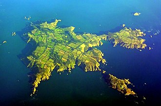
An aerial shot of the islands of Alderney (centre) and Burhou (upper right) in the Channel Islands.

An aerial shot of the islands of Alderney (centre) and Burhou (upper right) in the Channel Islands.


Le Braye, Alderney, and Burhou. Illustration from Alderney Guide (1851) by Louisa Lane Clarke (1812-1883)
Sources
Facts
Photographs
- Alderney aerial-2. Smb1001 / CC BY-SA 3.0
- Alderney aerial-2a. Smb1001 / CC BY-SA 3.0
- Alderney aerial-4. Smb1001 / CC BY-SA 3.0
- Le Braye Alderney. Man vyi / Public domain