Alderney
Aldernez, Aurigny
49°43′N 2°13′W
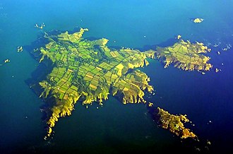
Alderney ( AWL-dər-nee; French: Aurigny [oʁiɲi]; Auregnais: Aoeur'gny) is the northernmost of the inhabited Channel Islands. It is part of the Bailiwick of Guernsey, a British Crown dependency. It is 3 miles (5 km) long and 1.5 miles (2.4 km) wide.

Terrain
49°43′N 2°13′W
Overview
Alderney ( AWL-dər-nee; French: Aurigny [oʁiɲi]; Auregnais: Aoeur'gny) is the northernmost of the inhabited Channel Islands. It is part of the Bailiwick of Guernsey, a British Crown dependency. It is 3 miles (5 km) long and 1.5 miles (2.4 km) wide. Alderney has an area of 3 square miles (8 km2), making it the third-largest island of the Channel Islands, and the second-largest in the bailiwick only to the island of Guernsey itself. Alderney is around 10 miles (16 km) to the west of the Cap de la Hague on the Cotentin Peninsula, Normandy, in France, 20 miles (32 km) to the northeast of Guernsey and 60 miles (100 km) from the south coast of Great Britain. It is the closest of the Channel Islands both to France and to the United Kingdom. It is separated from the Cap de la Hague by the dangerous Alderney Race (French: Raz Blanchard). As of March 2023, the island had a population of 2,167; natives are traditionally nicknamed vaques after the cows, or else lapins after the many rabbits seen in the island. Formally, they are known as Ridunians, from the Latin Riduna. The only parish of Alderney is the parish of St Anne, which covers the whole island. The main town, Saint Anne, historically known as La Ville ('The Town'), is often referred to as St Anne's by visitors and incomers, but rarely by locals (who, in normal conversation, still most frequently refer to the area centred on Victoria Street simply as Town). The town's "High Street", which formerly had a small handful of shops, is now almost entirely residential, forming a T-junction with Victoria Street at its highest point. The town area features an imposing church and an unevenly cobbled main street: Victoria Street (Rue Grosnez, the English name being adopted on the visit of Queen Victoria in 1854). There is one school (providing both primary and secondary education), a post office, hotels, restaurants, shops, and a bank. Other settlements include: Braye, Crabby, Longis, Mannez, La Banque, and Newtown.
From Wikipedia, CC BY-SA 4.0
Chart
Nearest islands
Also in Channel Islands




Also in British Isles

Great Britain
218,685 km²▲ 1,345 m
Major islands

Ireland
83,553 km²▲ 1,039 m
Major islands

Lewis and Harris
2,149 km²▲ 799 m
Minor islands

Isle of Skye
1,636 km²▲ 992 m
Minor islands

Mainland
953 km²▲ 450 m
Minor islands

Isle of Mull
885 km²▲ 966 m
Minor islands

Anglesey
680 km²▲ 178 m
Minor islands

Islay
618 km²▲ 491 m
Minor islands
Photographs

Landrover Defender on the island of Alderney, number plate modified

Vue sur l'île d'Aurigny depuis Goury, à Auderville.

The bow portion of Point Law rests on the rocks on the southwest coast of Alderney, Channel Islands.

Overhead shot of the ground from Mount Hale.

The still-intact door of a German bunker, part of St. Anne's battery defences, Alderney.

Vegetation of Alderney, showing examples of w:Cordyline australis (note, not palm trees)

The Braye Road station is one of the two stops of the Aldernay Railway, the only railway in the Channel Islands.

Alderney, Channel Islands

High Street, St. Anne, Alderney (Channel Islands)


Saint Anne, Alderney.

Number of air routes to and from Alderney since 1935. As plotted in Microsoft Excel.
Sources
Facts
Photographs
- Defender in Alderney IMG 3900acc . Christof46 / CC BY-SA 4.0
- Aurigny depuis Auderville. S. Plaine / CC BY-SA 4.0
- Point Law Wreck. Exlimey / CC BY-SA 4.0
- Arsenal Ground, Mount Hale, Alderney. In Vitrio / CC BY-SA 4.0
- Way Out - Alderney, Channel Islands, United Kingdom (14946101545). Richard from Leeds, Yorkshire, UK / CC BY 2.0
- Palms in Alderney. Andree Stephan / CC BY-SA 3.0
- Alderney Braye Road Station. Daniel Kraft / CC BY-SA 3.0
- Alderney, Channel Islands (32456297393). Richard from Leeds, Yorkshire, UK / CC BY 2.0
- High Str. St.Anne Alderney IMG 3889aa. Christof46 / CC BY-SA 4.0
- Flying over Alderney -b. Gene Selkov from Inverness, Scotland / CC BY 2.0
- St. Anne, Alderney. This image Dr. Blofeld (talk) / CC BY-SA 3.0
- Number of Air Routes to Alderney. Zadradr / CC BY-SA 3.0