Palaui Island
18°33′N 122°08′E
The Palaui Island Protected Landscape and Seascape is an island that is a protected area and national park in the municipality of Santa Ana in Cagayan, Philippines. It is located off the northeastern extremity of Luzon Island.

Terrain
18°33′N 122°08′E
Overview
The Palaui Island Protected Landscape and Seascape is an island that is a protected area and national park in the municipality of Santa Ana in Cagayan, Philippines. It is located off the northeastern extremity of Luzon Island.
From Wikipedia, CC BY-SA 4.0
Chart
Nearest islands
- Luzon362 km
- Marinduque Island574 km
- Catanduanes575 km
- Mindoro642 km
- Tablas Island686 km
- Masbate Island732 km
Also in Luzon

Luzon
104,935 km²▲ 2,928 m
Major islands

Palawan
11,346 km²▲ 2,963 m
Major islands

Mindoro
9,824 km²▲ 2,616 m
Minor islands

Masbate Island
3,209 km²▲ 682 m
Minor islands
Catanduanes
1,444 km²▲ 734 m
Minor islands

Busuanga Island
932 km²▲ 620 m
Minor islands
Marinduque Island
900 km²▲ 1,174 m
Minor islands

Tablas Island
671 km²▲ 665 m
Minor islands
Also in Philippines
Luzon
104,935 km²▲ 2,928 m
Major islands

Mindanao
93,885 km²▲ 2,954 m
Major islands

Negros
12,778 km²▲ 2,465 m
Major islands

Samar
12,435 km²▲ 890 m
Major islands

Panay
11,512 km²▲ 2,102 m
Major islands
Palawan
11,346 km²▲ 2,963 m
Major islands
Mindoro
9,824 km²▲ 2,616 m
Minor islands

Leyte
6,997 km²▲ 1,200 m
Minor islands
Also in Malay Archipelago

Borneo
732,069 km²▲ 4,095 m
Major islands

Sumatra
429,717 km²▲ 3,805 m
Major islands

Sulawesi
168,788 km²▲ 3,478 m
Major islands

Java
126,804 km²▲ 3,676 m
Major islands
Luzon
104,935 km²▲ 2,928 m
Major islands
Mindanao
93,885 km²▲ 2,954 m
Major islands

Timor
28,560 km²▲ 2,963 m
Minor islands

Halmahera
17,956 km²▲ 1,571 m
Minor islands
Also in Pacific Islands

New Guinea
774,566 km²▲ 4,884 m
Major islands
Japan
377,974 km²
Major islands
New Zealand
268,021 km²
Major islands

Honshu
227,970 km²▲ 3,776 m
Major islands
Luzon
104,935 km²▲ 2,928 m
Major islands
Mindanao
93,885 km²▲ 2,954 m
Major islands

Hokkaido
77,983 km²▲ 2,291 m
Minor islands

Sakhalin
74,571 km²▲ 1,609 m
Minor islands
Photographs

This is a photo of a cultural heritage property in the Philippines with ID

Palaui Island lies off the northwestern part of a large promontory in San Vicente, in the municipality of Santa Ana, Cagayan province.

The Palaui Island Protected Landscape and Seascape is a protected area and national park in the town of Santa Ana in Cagayan, Philippines. It is located off the northeastern extremity of Luzon Island, the largest island in the country.

The jagged costaline of Palui Island exposing volcanic origin of the island


while having our trip to the next island and saw this beautiful view

Palaui Island Cape Engano Lighthouse

Grassland and mountain trekking at Cagayan Valley's Palaui Island to reach the famous Cape Engano, Luzon's northeastern tip frontier. Shot by Schadow1 Expeditions during its mapping expedition of the island last 2013.

Two islands in Cagayan which serves as a backdrop of the seascape pictures.

Unknown authorUnknown author or not provided / Public domain
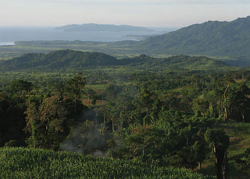
View of the northeast coast of Luzon from the foothills of Mt. Cagua, Municipality of Gonzaga. Note northern end of the Sierra Madre at right and Palaui Island in the background to the right. Photo: RMB.

Base Beach of Light House Palaui Island
Sources
Facts
Photographs
- Pacific Ocean View from Light House Top, Palaui Island Cagayan Philippines. Supermanslash / CC BY-SA 3.0
- Batanes view like of Palaui Island, Cagayan. LemuelSalibio / CC BY-SA 4.0
- Crocodile Island near Palaui Island. Joyfulwandering / CC BY-SA 4.0
- Jagged southwest coastline of Palui Island. Warrendering / CC BY-SA 4.0
- Palaui Island Sta. Ana, Cagayan. Joyfulwandering / CC BY-SA 4.0
- Sunrays in palaui. RhonVelarde01 / CC BY-SA 4.0
- Palaui Island Cape Engano Lighthouse (Yvette Tan) - Flickr. Yvette Tan / CC BY 2.0
- Leonardo Trail at Palaui Island. Ervin Malicdem / CC BY-SA 4.0
- Dos Hermanas Islands 1, Palaui, Cagayan. johrabino / CC BY-SA 4.0
- Philippine Island - Luzon Island - NARA - 68156947. Unknown authorUnknown author or not provided / Public domain
- View of the northeast coast of Luzon from the foothills of Mt. Cagua - ZooKeys-266-001-g005. Brown R, Siler C, Oliveros C, Welton L, Rock A, Swab J, Van Weerd M, van Beijnen J, Rodriguez D, Jose E, Diesmos A / CC BY 3.0
- Base Beach of Light House Palaui Island, Cagayan Philippines. Supermanslash / CC BY-SA 3.0