Hatutu
Hatutaa
7°54′S 140°34′W
Hatutu (also called Hatuta‘a) is a small island approximately 3 km (2 mi.) northeast of Eiao in the northern Marquesas Islands. It is approximately 3 km (2 mi) from Eiao by a channel 50 meters deep. It was also known as Hancock, Chanal, Langdon, and Nexsen.
7°54′S 140°34′W
Overview
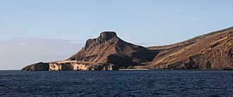
Hatutu (also called Hatuta‘a) is a small island approximately 3 km (2 mi.) northeast of Eiao in the northern Marquesas Islands. It is approximately 3 km (2 mi) from Eiao by a channel 50 meters deep. It was also known as Hancock, Chanal, Langdon, and Nexsen. Hatutu is administratively part of the commune (municipality) of Nuku-Hiva, itself in the administrative subdivision of the Marquesas Islands. It consists of a high central ridge, which runs the full 6.5 km (4 mi.) length of the island. The ridge rises to heights up to 428 m (1,404 ft.) above sea level. Its only anchorage point is in the south of the island for small ships.
The island was discovered by an American named Joseph Ingraham in April of 1791, and two months later by a Frenchman named Étienne Marchand. There has never been a permanent settlement on the island; however, in 1798, Edmund Fanning reported seeing smoke plumes, suggesting temporary settlement by native people. In 1992, Hatutu was declared a nature reserve: the Hatutu Nature Reserve. The island is an important nesting ground for red-footed booby, black noddy, white tern, great frigatebird, and masked booby, and home to the endemic northern Marquesan reed warbler and the Marquesan ground dove. It is also the largest breeding site of Phoenix Petrel in French Polynesia. Many native seabirds come to nest on the island throughout the year. The island is also plagued by Polynesian rat (Rattus exulans), a species introduced by humans sometime in the last several hundred years. The rats likely prey on native animals and plants, potentially changing the island's ecosystem dynamics.
From Wikipedia, CC BY-SA 4.0
Chart
Nearest islands
Also in Northern Marquesas group




Also in Marquesas Islands


Also in Polynesia
New Zealand
268,021 km²
Major islands
Samoa
2,842 km²
Minor islands
Rangiroa
1,446 km²▲ 12 m
Minor islands
Fakarava
1,112 km²
Minor islands
Tonga
749 km²
Minor islands
Hao
720 km²▲ 3 m
Minor islands
Apataki
706 km²
Minor islands
Makemo
603 km²
Minor islands
Also in Leeward Islands
New Zealand
268,021 km²
Major islands
Samoa
2,842 km²
Minor islands
Rangiroa
1,446 km²▲ 12 m
Minor islands
Fakarava
1,112 km²
Minor islands
Tonga
749 km²
Minor islands
Hao
720 km²▲ 3 m
Minor islands
Apataki
706 km²
Minor islands
Makemo
603 km²
Minor islands
Also in Society Islands
New Zealand
268,021 km²
Major islands
Samoa
2,842 km²
Minor islands
Rangiroa
1,446 km²▲ 12 m
Minor islands
Fakarava
1,112 km²
Minor islands

Tahiti
1,044 km²▲ 2,241 m
Minor islands
Tonga
749 km²
Minor islands
Hao
720 km²▲ 3 m
Minor islands
Apataki
706 km²
Minor islands
Also in Pacific Islands

New Guinea
774,566 km²▲ 4,884 m
Major islands
Japan
377,974 km²
Major islands
New Zealand
268,021 km²
Major islands

Honshu
227,970 km²▲ 3,776 m
Major islands

Luzon
104,935 km²▲ 2,928 m
Major islands

Mindanao
93,885 km²▲ 2,954 m
Major islands

Hokkaido
77,983 km²▲ 2,291 m
Minor islands

Sakhalin
74,571 km²▲ 1,609 m
Minor islands