Eiao
8°01′S 140°42′W
Eiao is the largest of the extreme northwestern Marquesas Islands. The island is uninhabited, but is administratively part of the commune (municipality) of Nuku-Hiva, itself in the administrative subdivision of the Marquesas Islands.

Terrain
8°01′S 140°42′W
Overview
Eiao is the largest of the extreme northwestern Marquesas Islands. The island is uninhabited, but is administratively part of the commune (municipality) of Nuku-Hiva, itself in the administrative subdivision of the Marquesas Islands. As of 2022, the only settlement on the island is a small shelter on the north coast of Vaithua Bay with a water tap. There are some small artificial structures in the north of the island, most likely for archeological purposes. There is a small shrine of Mother Mary somewhere along a trail to the plateau at the top of the island.
From Wikipedia, CC BY-SA 4.0
Chart
Nearest islands
Also in Northern Marquesas group



Also in Marquesas Islands


Also in Polynesia
New Zealand
268,021 km²
Major islands
Samoa
2,842 km²
Minor islands
Rangiroa
1,446 km²▲ 12 m
Minor islands
Fakarava
1,112 km²
Minor islands
Tonga
749 km²
Minor islands
Hao
720 km²▲ 3 m
Minor islands
Apataki
706 km²
Minor islands
Makemo
603 km²
Minor islands
Also in Leeward Islands
New Zealand
268,021 km²
Major islands
Samoa
2,842 km²
Minor islands
Rangiroa
1,446 km²▲ 12 m
Minor islands
Fakarava
1,112 km²
Minor islands
Tonga
749 km²
Minor islands
Hao
720 km²▲ 3 m
Minor islands
Apataki
706 km²
Minor islands
Makemo
603 km²
Minor islands
Also in Society Islands
New Zealand
268,021 km²
Major islands
Samoa
2,842 km²
Minor islands
Rangiroa
1,446 km²▲ 12 m
Minor islands
Fakarava
1,112 km²
Minor islands

Tahiti
1,044 km²▲ 2,241 m
Minor islands
Tonga
749 km²
Minor islands
Hao
720 km²▲ 3 m
Minor islands
Apataki
706 km²
Minor islands
Also in Pacific Islands

New Guinea
774,566 km²▲ 4,884 m
Major islands
Japan
377,974 km²
Major islands
New Zealand
268,021 km²
Major islands

Honshu
227,970 km²▲ 3,776 m
Major islands

Luzon
104,935 km²▲ 2,928 m
Major islands

Mindanao
93,885 km²▲ 2,954 m
Major islands

Hokkaido
77,983 km²▲ 2,291 m
Minor islands

Sakhalin
74,571 km²▲ 1,609 m
Minor islands
Photographs

Eiao. Photo de la baie de Vaituha après des pluies. Les eaux de la baie sont colorées en rouge par la latérite durant plusieurs jours. Photo prise lors dela mission scientifique DIREN


EIAO: L'île est gravement érodée suite à l'introduction et à la prolifération de moutons et de porcs. Photo prise durant la mission scientifique de la DIREN de Polynésie Française

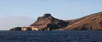
Eaio (Marquesas Island, French Polynesia) western coast
Sources
Facts
Photographs
- EIAO 2007 Baie de Vaituha.. MCHX (Michel CHARLEUX) / CC BY-SA 3.0
- EIAO 2007 La côte sud-est, limite de l'ancien cratère.. Unknown author / CC BY-SA 3.0
- EIAO 2007 Le plateau est gravement érodé.. MCHX (Michel CHARLEUX) / CC BY-SA 3.0
- Eiao. Sardon / CC BY 3.0