Cabilao Island
9°53′N 123°46′E
Cabilao is a Philippine island in the Cebu Strait, part of Bohol Province. It is home to the only natural lake in the province: Cabilao Island Lake, also called Lake Lanao.

Terrain
9°53′N 123°46′E
Overview
Cabilao is a Philippine island in the Cebu Strait, part of Bohol Province. It is home to the only natural lake in the province: Cabilao Island Lake, also called Lake Lanao. The island, part of the Municipality of Loon, has five barangays (Cabacongan, Cambaquiz, Looc, Pantudlan, and Talisay), and has a total population of 4,636 people, who primarily depend on fishing and agriculture, as well as tourism. Notable indigenous products are handcrafted mats,hats and bayongs, weaved from romblon (pandanus) leaves by a cooperation of weavers using a shared service facility in Pantudlan. The entire island was proclaimed as a Mangrove Swamp Forest Reserve under Proclamation No. 2152 in 1981, and confirmed by the National Integrated Protected Areas System Act of 1992 (Republic Act No. 7586). But since only a small area around Cabilao Island Lake actually has any mangroves worthy of being protected, House Bill No. 5108 of February 2017 removed the island's protection under the NIPAS Act. Proclamation No. 1801, signed in November 1978, declared the entire island a tourist zone and marine reserve under the administration and control of the Philippine Tourism Authority (PTA). The island is accessible by outrigger boats that connect Mocpoc on the western end of Sandingan Island to the pier on the eastern side of Cabilao Island. There are only a number of cars on the island, and local transportation consists of motorcycles and a few tricycles.
From Wikipedia, CC BY-SA 4.0
Chart
Nearest islands
Also in Visayas

Also in Philippines

Luzon
104,935 km²▲ 2,928 m
Major islands

Mindanao
93,885 km²▲ 2,954 m
Major islands

Negros
12,778 km²▲ 2,465 m
Major islands

Samar
12,435 km²▲ 890 m
Major islands

Panay
11,512 km²▲ 2,102 m
Major islands

Palawan
11,346 km²▲ 2,963 m
Major islands

Mindoro
9,824 km²▲ 2,616 m
Minor islands

Leyte
6,997 km²▲ 1,200 m
Minor islands
Also in Malay Archipelago

Borneo
732,069 km²▲ 4,095 m
Major islands

Sumatra
429,717 km²▲ 3,805 m
Major islands

Sulawesi
168,788 km²▲ 3,478 m
Major islands

Java
126,804 km²▲ 3,676 m
Major islands
Luzon
104,935 km²▲ 2,928 m
Major islands
Mindanao
93,885 km²▲ 2,954 m
Major islands

Timor
28,560 km²▲ 2,963 m
Minor islands

Halmahera
17,956 km²▲ 1,571 m
Minor islands
Also in Pacific Islands

New Guinea
774,566 km²▲ 4,884 m
Major islands
Japan
377,974 km²
Major islands
New Zealand
268,021 km²
Major islands

Honshu
227,970 km²▲ 3,776 m
Major islands
Luzon
104,935 km²▲ 2,928 m
Major islands
Mindanao
93,885 km²▲ 2,954 m
Major islands

Hokkaido
77,983 km²▲ 2,291 m
Minor islands

Sakhalin
74,571 km²▲ 1,609 m
Minor islands
Photographs
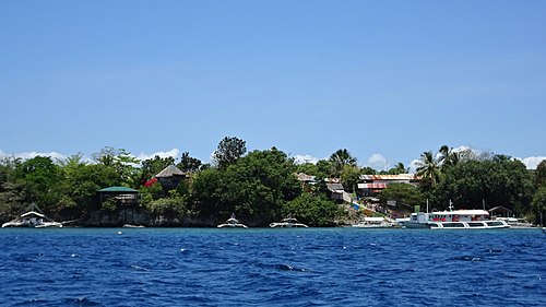
Cabilao Island, Bohol, Philippines

Cabilao Island, Bohol, Philippines

Loon, Bohol, Philippines


Sources
Facts
Photographs
- Cabilao Island 1. P199 / CC BY-SA 4.0
- Cabilao Island 2. P199 / CC BY-SA 4.0
- Loon, Bohol, Philippines - panoramio. yuichiro anazawa / CC BY 3.0
- Bohol Cabilao Romblon SLT bags5. Unknown author / CC BY-SA 4.0
- Bohol Cabilao Romblon SLT6. Unknown author / CC BY-SA 4.0