Caribbean SeaFrance, Trinidad & Tobago, Dominica, St. Lucia, United States, St. Kitts & Nevis, St. Vincent & Grenadines and Grenada
16°15′N 61°34′W
French West Indies
Part of Windward Islands
The French West Indies or French Antilles (French: Antilles françaises, [ɑ̃tij fʁɑ̃sɛːz]; Antillean Creole: Antiy fwansé) were the parts of France located in the Antilles islands of the Caribbean:

Chart
Overview
The French West Indies or French Antilles (French: Antilles françaises, [ɑ̃tij fʁɑ̃sɛːz]; Antillean Creole: Antiy fwansé) were the parts of France located in the Antilles islands of the Caribbean:
The two overseas departments of: Guadeloupe, including the islands of Basse-Terre, Grande-Terre, Les Saintes, Marie-Galante, and La Désirade. Martinique The two overseas collectivities of: Saint Martin, the northern half of the island with the same name, the southern half is Sint Maarten, a constituent country of the Kingdom of the Netherlands. Saint Barthélemy
From Wikipedia, CC BY-SA 4.0
Census, cataloged
- Major islands6
- Minor islands37
- Islets166
- Rocks & skerries131
Major islands
Trinidad
- Area
- 4,823 km²
- High point
- 940 m
Trinidad is the largest and most populous island of the Republic of Trinidad and Tobago. The island lies 11 km (7 mi) off the northeastern coast of Venezuela and sits on the continental shelf of South America. It is the southernmost island in the Caribbean.
Dominica
- Area
- 751 km²
- High point
- 1,447 m
Dominica officially the Commonwealth of Dominica, is an island country in the Caribbean. It is part of the Windward Islands chain in the Lesser Antilles archipelago in the Caribbean Sea. The capital, Roseau, is located on the western side of the island.
Saint Lucia
- Area
- 603 km²
- High point
- 950 m
Saint Lucia (also written as St. Lucia) is an island country in the eastern and southern Caribbean. Part of the Windward Islands of the Lesser Antilles, it is located north/northeast of the island of Saint Vincent, northwest of Barbados and south of Martinique.
Tobago
- Area
- 300 km²
- High point
- 580 m
Tobago, officially the Ward of Tobago, is an island and ward in Trinidad and Tobago. It is 35 kilometres (20 nautical miles) northeast of the larger island of Trinidad and about 160 kilometres (85 nautical miles) off Venezuela's northeastern coast. It is southeast of Grenada and southwest of Barbados.
Saint Croix
- Area
- 217 km²
- High point
- 334 m
Saint Croix ( KROY; Spanish: Santa Cruz; Dutch: Sint-Kruis; French: Sainte-Croix; Danish and Norwegian: Sankt Croix; Taino: Ay Ay) is an island in the Caribbean, and a county and constituent district of the United States Virgin Islands (USVI), an unincorporated territory of the United States.
Saint Kitts
- Area
- 168 km²
- High point
- 1,156 m
Saint Kitts, also known as Saint Christopher, is an island in the West Indies. The west side of the island borders the Caribbean Sea, and the eastern coast faces the Atlantic Ocean. Saint Kitts and the neighbouring island of Nevis constitute one country: the Federation of Saint Kitts and Nevis.


Minor islands

Basse-Terre Island
- Area
- 847 km²
- High point
- 1,467 m

Grande-Terre
- Area
- 593 km²
- High point
- 136 m

Saint Vincent
- Area
- 344 km²
- High point
- 1,234 m

Grenada
- Area
- 313 km²
- High point
- 840 m

Marie-Galante
- Area
- 159 km²
- High point
- 204 m

Carriacou
- Area
- 32.1 km²
- High point
- 291 m

La Désirade
- Area
- 19.7 km²
- High point
- 279 m

Bequia
- Area
- 16.1 km²
- High point
- 265 m

Union Island
- Area
- 8.7 km²
- High point
- 304 m

Canouan
- Area
- 7.7 km²
- High point
- 232 m
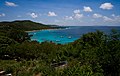
Mustique
- Area
- 5.6 km²
- High point
- 144 m
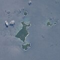
Ronde Island
- Area
- 2.5 km²
- High point
- 153 m

Petite Martinique
- Area
- 2 km²
- High point
- 195 m
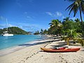
Mayreau
- Area
- 1.8 km²
- High point
- 98 m

Quatre
- Area
- 1.5 km²
- High point
- 136 m

Baliceaux
- Area
- 1.3 km²
- High point
- 117 m

Terre de Bas
- Area
- 1.3 km²
- High point
- 9 m

îlet à Fajou
- Area
- 1.1 km²
- High point
- 9 m
Caille Island
- Area
- 0.63 km²
- High point
- 69 m
Battowia
- Area
- 0.63 km²
- High point
- 194 m
Large Island
- Area
- 0.59 km²
- High point
- 57 m
Petit Mustique
- Area
- 0.5 km²
- High point
- 99 m

Palm Island
- Area
- 0.43 km²
- High point
- 28 m

Petit Saint Vincent
- Area
- 0.41 km²
- High point
- 75 m
Frigate Island
- Area
- 0.39 km²
- High point
- 51 m
Hog Island
- Area
- 0.35 km²
- High point
- 47 m
Terre de Haut
- Area
- 0.31 km²
- High point
- 8 m

Petite Nevis
- Area
- 0.29 km²
- High point
- 83 m
Calivigny Island
- Area
- 0.28 km²
- High point
- 30 m
Saline Island
- Area
- 0.27 km²
- High point
- 61 m
Îlet Cochon
- Area
- 0.26 km²
- High point
- 15 m
Grand Tantes
- Area
- 0.23 km²
- High point
- 84 m
Diamond Island
- Area
- 0.22 km²
- High point
- 170 m
Petite Canouan
- Area
- 0.17 km²
- High point
- 50 m
Green Island
- Area
- 0.13 km²
- High point
- 61 m
Ruth Island
- Area
- 0.11 km²
- High point
- 6 m
Savan
- Area
- 0.1 km²
- High point
- 39 m
Rocks & skerries
On the chart above, at its closest zooms.
Listing 43 of 340; the rest are on the chart.
Figures
Comparative heights
- Basse-Terre: 1,467 m
- Dominica: 1,447 m
- Saint Vincent: 1,234 m
- Saint Kitts: 1,156 m
- Saint Lucia: 950 m
- Trinidad: 940 m
- Grenada: 840 m
- Tobago: 580 m
- Saint Croix: 334 m
- Union: 304 m
- Carriacou: 291 m
- La Désirade: 279 m
- Bequia: 265 m
- Canouan: 232 m
To the same scale
Islands by area
| Trinidad | 4,823 km² |
| Basse-Terre Island | 847 km² |
| Dominica | 751 km² |
| Saint Lucia | 603 km² |
| Grande-Terre | 593 km² |
| Saint Vincent | 344 km² |
| Grenada | 313 km² |
| Tobago | 300 km² |
| Saint Croix | 217 km² |
| Saint Kitts | 168 km² |
| Marie-Galante | 159 km² |
| Carriacou | 32.1 km² |
| La Désirade | 19.7 km² |
| Bequia | 16.1 km² |
| Union Island | 8.7 km² |
| Canouan | 7.7 km² |
| Mustique | 5.6 km² |
| Ronde Island | 2.5 km² |
| Petite Martinique | 2 km² |
| Mayreau | 1.8 km² |
| Quatre | 1.5 km² |
| Baliceaux | 1.3 km² |
| Terre de Bas | 1.3 km² |
| îlet à Fajou | 1.1 km² |
| Caille Island | 0.63 km² |
| Battowia | 0.63 km² |
| Large Island | 0.59 km² |
| Petit Mustique | 0.5 km² |
| Palm Island | 0.43 km² |
| Petit Saint Vincent | 0.41 km² |
| Frigate Island | 0.39 km² |
| Hog Island | 0.35 km² |
| Terre de Haut | 0.31 km² |
| Petite Nevis | 0.29 km² |
| Calivigny Island | 0.28 km² |
| Saline Island | 0.27 km² |
| Îlet Cochon | 0.26 km² |
| Grand Tantes | 0.23 km² |
| Diamond Island | 0.22 km² |
| Petite Canouan | 0.17 km² |
| Green Island | 0.13 km² |
| Ruth Island | 0.11 km² |
| Savan | 0.1 km² |
Groups within
Overlapping groups
Photographs

Brimstone Hill Fortress, UNESCO World Heritage Site Ref. Number 910, March 2016. Detail of the Orientation Center.

La plage des salines en Martinique

Quinam Bay, Columbus Channel, South Coast, Trinidad
Sources
Facts
Photographs
- Saint Kitts - Brimstone Hill Fortress 04. Martin Falbisoner / CC BY-SA 4.0
- Martinique Beach (Salines). Barbacha|Nicolas BOUTHORS / Public domain
- Quinam bay, Columbus Channel, South Coast, Trinidad & Tobago. Kalamazadkhan / CC BY-SA 3.0
- Guadeloupe banner Frangipani. Jayen466 / CC0