Samos
Σάμος, Számosz, Samo
37°43′N 26°49′E
0 mi) Mycale Strait. It is also a separate regional unit of the North Aegean region.

Terrain
37°43′N 26°49′E
Overview
Samos (, also US: ; Greek: Σάμος, romanized: Sámos, Greek pronunciation: [ˈsa.mos]) is a Greek island in the eastern Aegean Sea, south of Chios, north of Patmos and the Dodecanese archipelago, and off the coast of western Turkey, from which it is separated by the 1.6-kilometre-wide (1.0 mi) Mycale Strait. It is also a separate regional unit of the North Aegean region. In ancient times, Samos was an especially rich and powerful city-state, particularly known for its vineyards and wine production. It is home to Pythagoreion and the Heraion of Samos, a UNESCO World Heritage Site that includes the Eupalinian aqueduct, a marvel of ancient engineering. Samos is the birthplace of the Greek philosopher and mathematician Pythagoras, after whom the Pythagorean theorem is named, the philosophers Melissus of Samos and Epicurus, and the astronomer Aristarchus of Samos, the first known individual to propose that the Earth revolves around the Sun. Samian wine was well known in antiquity and is still produced on the island. The island was governed by the semi-autonomous Principality of Samos under Ottoman suzerainty from 1835 until it joined Greece in March 1913.
From Wikipedia, CC BY-SA 4.0
Chart
Nearest islands
Also in Southern Sporades


Also in Sporades


Also in Aegean Islands


Photographs
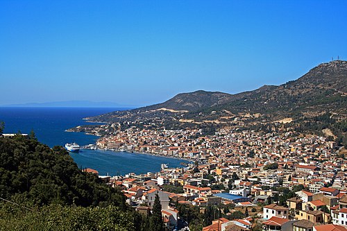
View of Samos town, capital of Samos island, Greece.

Samos, Greece

Samos, Greece

Samos, Greece

Samos, Greece

Macchia auf Samos

This is a photograph of a Natura 2000 protected area with ID

This is a photograph of a Natura 2000 protected area with ID

Published on Flickr in album "Samos"

Πανοραμική άποψη

Καδράρισμα απο ψηλά σε ωραία ώρα

Outdoor Basketball Court in Karlovasi, Samos
Sources
Facts
Photographs
- Samos 049 2009. Pe-sa / CC BY-SA 3.0
- Samos Jul 2023 20 54 08 059000. Robot8A / CC BY-SA 4.0
- Samos Jun 2023 18 56 18 278000. Robot8A / CC BY-SA 4.0
- Samos Jul 2023 20 54 19 502000. Robot8A / CC BY-SA 4.0
- Samos Jun 2023 18 56 14 620000. Robot8A / CC BY-SA 4.0
- Macchia auf Samos (KPFC) 01. KPFC / CC BY-SA 4.0
- Ομιχλώδες δάσος στο Όρος Καρβούνης στη Σάμο. GrigorisKoulouriotis / CC BY-SA 4.0
- Τα αρχαία Λατομεία στους πρόποδες του Όρους Καρβούνης στη Σάμο. GrigorisKoulouriotis / CC BY-SA 4.0
- Samos, Greece (3437360419). Raphael Schön from Vienna, Austria / CC BY 2.0
- Samos' beach. Porouclas / CC BY-SA 4.0
- Samos' village. Porouclas / CC BY-SA 4.0
- Outdoor Basketball Court in Karlovasi, Samos. Samos@Wikipedia Project / CC BY-SA 4.0