Greece
36°00′N 27°00′E
Southern Sporades
Part of Sporades
The Southern Sporades (Greek: Νότιες Σποράδες, romanized: Nóties Sporádes) are Greek islands situated between the Cyclades and Turkey. They correspond to the Dodecanese plus a few northern islands (especially Samos, Icaria and Fournoi Korseon).

Chart
Overview
The Southern Sporades (Greek: Νότιες Σποράδες, romanized: Nóties Sporádes) are Greek islands situated between the Cyclades and Turkey. They correspond to the Dodecanese plus a few northern islands (especially Samos, Icaria and Fournoi Korseon).
From Wikipedia, CC BY-SA 4.0
Census, cataloged
- Major islands21
- Minor islands89
- Islets205
- Rocks & skerries1,720
Major islands
Rhodes
- Area
- 1,400 km²
- High point
- 1,213 m
Rhodes ( ; Greek: Ρόδος, romanized: Ródos [ˈroðos]) is the largest of Greece's Dodecanese islands and their historical capital, as well as the ninth largest island in the Mediterranean Sea.
Samos
- Area
- 476 km²
- High point
- 1,443 m
0 mi) Mycale Strait. It is also a separate regional unit of the North Aegean region.
Karpathos
- Area
- 300 km²
- High point
- 1,215 m
Karpathos, also Carpathos, is the second largest of the Greek Dodecanese islands, in the southeastern Aegean Sea. Together with the neighboring smaller Saria Island it forms the municipality of Karpathos, which is part of the regional unit Karpathos-Kasos.
Kos
- Area
- 287 km²
- High point
- 846 m
Kos or Cos (; Greek: Κως [kos]) is a Greek island, part of the Dodecanese island chain in the southeastern Aegean Sea. Kos is the third largest island of the Dodecanese, after Rhodes and Karpathos; it has a population of 37,089 (2021 census), making it the second most populous of the Dodecanese after Rhodes.
Kalymnos
- Area
- 110 km²
- High point
- 676 m
Kalymnos (Greek: Κάλυμνος; Modern Greek pronunciation: [ˈkalimnos]) is a Greek island and municipality in the southeastern Aegean Sea.
Astypalaia
- Area
- 96.5 km²
- High point
- 482 m
Astypalaia, is a Greek island with 1,376 residents (2021 census). It belongs to the Dodecanese, an archipelago of fifteen major islands in the southeastern Aegean Sea.
Tilos
- Area
- 61.5 km²
- High point
- 654 m
Tílos (Greek: Τήλος; Ancient Greek: Τῆλος, romanized: Telos) is a small Greek island and municipality located in the Aegean Sea. It is part of the Dodecanese group of islands, and lies midway between Kos and Rhodes. In 2021, the island had a population of 746 people. 913 sq mi).
Symi
- Area
- 57.5 km²
- High point
- 617 m
Symi, also transliterated as Syme or Simi (Greek: Σύμη), is a Greek island and municipality. It is mountainous and has the harbour town of Symi and its adjacent upper town Ano Symi, as well as several smaller population centres, beaches and areas of significance in history and mythology.
Nisyros
- Area
- 41.1 km²
- High point
- 698 m
Nisyros, also spelled Nisiros (Greek: Νίσυρος, romanized: Nísyros; Modern Greek pronunciation: [ˈnisiros]), is a volcanic Greek island and municipality located in the Aegean Sea. It is part of the Dodecanese group of islands, situated between the islands of Kos and Tilos.
Patmos
- Area
- 33.9 km²
- High point
- 264 m
Patmos is a Greek island in the Aegean Sea. It is famous as the place where, according to Christian belief, John of Patmos received the vision found in the Book of Revelation of the New Testament, and where the book was written.
Saria Island
- Area
- 20.5 km²
- High point
- 620 m
Saria Island (Greek: Σαρία), anciently known as Sarus or Saros (Ancient Greek: Σάρος), is an island in Greece. It is a rocky, volcanic island just to the north of Karpathos, separated from it by a 100 m (330 ft) wide strait. It is part of the Dodecanese archipelago.
Leipsoi
- Area
- 15.8 km²
- High point
- 277 m
Leipsoi (Greek: Λειψοί [liˈpsi]; also: Lipsi; Ancient Greek: Λέψια, Lepsia) is an island south of Samos and to the north of Leros in Greece. It is well served with ferries passing between Patmos and Leros and on the main route for ferries from Piraeus.
Pserimos
- Area
- 14.5 km²
- High point
- 268 m
Pserimos (Greek: Ψέριμος, Modern Greek pronunciation: [ˈpserimos]) is a small Greek island in the Dodecanese chain, lying between Kalymnos and Kos near the coast of Turkey. It is part of the municipality of Kalymnos.
Levitha
- Area
- 9.1 km²
- High point
- 141 m
Levitha (Greek: Λέβιθα), known in classical antiquity as Lebinthus or Lebinthos (Ancient Greek: Λέβινθος) is a small Greek island located in the east of the Aegean Sea, between Kinaros and Kalymnos, part of the Dodecanese islands. It is part of the municipality of Leros.
Arkoi
- Area
- 6.7 km²
- High point
- 112 m
Arkoi (Greek: Αρκοί; also Arkioi (Αρκιοί)) is a small Greek island in the Dodecanese archipelago, located east of Patmos, north of Leipsoi and southwest of Agathonisi. The island belongs to the municipality of Patmos, which is part of the South Aegean region, and had a population of 54 inhabitants at the 2001 census.
Telendos
- Area
- 4.6 km²
- High point
- 457 m
Telendos, (Greek: Τέλενδος) is a Greek island in the southeastern Aegean Sea, belonging to the Dodecanese. It is approximately 1 km (0.6 mi) off the coast of the larger island of Kalymnos, of which it is administratively a part. It was a member of the Delian League.
Gyali
- Area
- 4.6 km²
- High point
- 179 m
Gyali is a Greek volcanic island in the Dodecanese, located halfway between the south coast of Kos (Kardamaina) and Nisyros. It consists of rhyolitic obsidian lava domes and pumice deposits (which are mined in huge quantities).
Farmakonisi
- Area
- 3.9 km²
- High point
- 108 m
Farmakonisi (Greek: Φαρμακονήσι) is a small Greek island and community of the Dodecanese, in the Aegean Sea, Greece. It lies in the middle between the chain of the Dodecanese islands in the west, and the coast of Asia Minor (Turkey) in the east.
Kalolimnos
- Area
- 1.9 km²
- High point
- 106 m
Kalolimnos (Greek: Καλόλιμνος) is a small Greek island in the Dodecanese chain, lying between Kalymnos and Imia, opposite the coast of Turkey, in the Aegean Sea. It is part of the municipality of Kalymnos.


Syrna
- Area
- 8.3 km²
- High point
- 321 m
Syrna (Greek: Σύρνα; anciently, Syrnos (Ancient Greek: Σύρνος) or Sirna or Agios Ioannis, is a small island about 4 km2 in area to the south-east of Astypalaia in the Dodecanese group of Greek islands, situated to the south-east of the country. It is mostly covered with juniper and garrigue scrub.
Kinaros
- Area
- 4.5 km²
- High point
- 287 m
Kinaros (Greek: Κίναρος), is a small Greek island in the Aegean Sea, named after the artichoke (κίναρα; kinara) which it produced. 5 nautical miles west-southwest of Levitha. 5 km². The island's highest point is 296m. It was noted by several ancient authors including Pliny the Elder, Pomponius Mela, and Athenaeus.
Minor islands

Icaria
- Area
- 254 km²
- High point
- 1,037 m

Kasos
- Area
- 65.8 km²
- High point
- 597 m

Leros
- Area
- 53.9 km²
- High point
- 331 m

Fourni Island
- Area
- 30.1 km²
- High point
- 509 m

Halki
- Area
- 27.4 km²
- High point
- 593 m

Agathonisi
- Area
- 13.4 km²
- High point
- 208 m

Thymaina
- Area
- 10.1 km²
- High point
- 463 m

Alimia
- Area
- 7.4 km²
- High point
- 268 m

Skantzoura
- Area
- 6.3 km²
- High point
- 104 m

Nimos
- Area
- 4.6 km²
- High point
- 363 m
Sarakino
- Area
- 3.3 km²
- High point
- 132 m

Armathia
- Area
- 2.5 km²
- High point
- 109 m

Agios Minas Island
- Area
- 2.2 km²
- High point
- 205 m

Seskli
- Area
- 1.8 km²
- High point
- 122 m
Ofidoussa
- Area
- 1.8 km²
- High point
- 133 m

Prasonisi
- Area
- 1.5 km²
- High point
- 80 m
Archangelos
- Area
- 1.5 km²
- High point
- 132 m
Kandelioussa
- Area
- 1.4 km²
- High point
- 104 m
Kounoupi
- Area
- 1.4 km²
- High point
- 90 m
Agreloussa
- Area
- 1.3 km²
- High point
- 118 m

Zaforas
- Area
- 1.3 km²
- High point
- 220 m

Pergousa
- Area
- 1.2 km²
- High point
- 75 m
Pachia
- Area
- 1.2 km²
- High point
- 138 m

Astakida
- Area
- 0.98 km²
- High point
- 139 m
Pontikoussa
- Area
- 0.98 km²
- High point
- 227 m

Samiopoula
- Area
- 0.96 km²
- High point
- 153 m

Gaidouronisi
- Area
- 0.75 km²
- High point
- 155 m

Plati Pserimou
- Area
- 0.68 km²
- High point
- 42 m
Agios Theodoros
- Area
- 0.66 km²
- High point
- 96 m
Kisiria
- Area
- 0.63 km²
- High point
- 68 m
Platia
- Area
- 0.62 km²
- High point
- 39 m
Megalo Fokionisi
- Area
- 0.61 km²
- High point
- 53 m
Makry
- Area
- 0.61 km²
- High point
- 96 m
Plakida
- Area
- 0.57 km²
- High point
- 76 m

Antitilos
- Area
- 0.5 km²
- High point
- 119 m
Mesonisi
- Area
- 0.49 km²
- High point
- 42 m
Koutsomytis
- Area
- 0.48 km²
- High point
- 66 m
Nera
- Area
- 0.48 km²
- High point
- 50 m
Nero
- Area
- 0.44 km²
- High point
- 63 m

Chamili
- Area
- 0.44 km²
- High point
- 36 m
Thymenaki
- Area
- 0.42 km²
- High point
- 127 m
Chondro
- Area
- 0.38 km²
- High point
- 90 m
Tragonisi
- Area
- 0.36 km²
- High point
- 102 m
Piganousa
- Area
- 0.35 km²
- High point
- 139 m

Marathos Island
- Area
- 0.34 km²
- High point
- 50 m
Nisos
- Area
- 0.33 km²
- High point
- 48 m
Megalo Liadi
- Area
- 0.32 km²
- High point
- 50 m
Anydros
- Area
- 0.31 km²
- High point
- 100 m
Makronisi
- Area
- 0.3 km²
- High point
- 20 m
Tragousa
- Area
- 0.3 km²
- High point
- 58 m
Kalovolos
- Area
- 0.29 km²
- High point
- 60 m
Kalavros
- Area
- 0.29 km²
- High point
- 99 m
Agia Kyriaki islets
- Area
- 0.28 km²
- High point
- 23 m
Chiliomódi
- Area
- 0.27 km²
- High point
- 107 m
Divounia 1
- Area
- 0.26 km²
- High point
- 95 m
Makronisi
- Area
- 0.26 km²
- High point
- 41 m
Frangkos
- Area
- 0.24 km²
- High point
- 72 m
Praso Skantzouras
- Area
- 0.24 km²
- High point
- 44 m
Glyno
- Area
- 0.24 km²
- High point
- 39 m
Kouneli
- Area
- 0.22 km²
- High point
- 51 m
Megalos Adelfos islet
- Area
- 0.22 km²
- High point
- 129 m
Strogyli
- Area
- 0.21 km²
- High point
- 71 m

Strongylí
- Area
- 0.21 km²
- High point
- 120 m
Makronisi
- Area
- 0.21 km²
- High point
- 34 m
Strongyli
- Area
- 0.21 km²
- High point
- 88 m
Divounia 2
- Area
- 0.21 km²
- High point
- 95 m
Faradonisia
- Area
- 0.2 km²
- High point
- 60 m
Gaidaros
- Area
- 0.19 km²
- High point
- 72 m
Glaros
- Area
- 0.19 km²
- High point
- 33 m
Chondrós
- Area
- 0.18 km²
- High point
- 98 m
Unnamed island
- Area
- 0.18 km²
- High point
- 28 m
Strongyli
- Area
- 0.16 km²
- High point
- 84 m
Arefousa
- Area
- 0.16 km²
- High point
- 46 m
Stefania
- Area
- 0.15 km²
- High point
- 25 m
Safonidi
- Area
- 0.15 km²
- High point
- 44 m
Unnamed island
- Area
- 0.14 km²
- High point
- 84 m
Agia Kyriaki
- Area
- 0.14 km²
- High point
- 56 m
Pitta
- Area
- 0.13 km²
- High point
- 15 m
Mesos Adelfos islet
- Area
- 0.13 km²
- High point
- 67 m
Astakidopoulo
- Area
- 0.12 km²
- High point
- 42 m
Agios Nikolaos
- Area
- 0.12 km²
- High point
- 78 m
Megalo Glaronisi
- Area
- 0.12 km²
- High point
- 32 m
Gialesino
- Area
- 0.11 km²
- High point
- 43 m
Polemika
- Area
- 0.11 km²
- High point
- 42 m
Agia Kyriaki
- Area
- 0.11 km²
- High point
- 67 m

Sokastro
- Area
- 0.11 km²
- High point
- 84 m
Kasonisi
- Area
- 0.11 km²
- High point
- 22 m
Mikro Fokionisi
- Area
- 0.1 km²
- High point
- 23 m
Megalonisi
- Area
- 0.1 km²
- High point
- 40 m
Rocks & skerries
On the chart above, at its closest zooms.
Listing 110 of 2035; the rest are on the chart.
Figures
Comparative heights
To the same scale
Islands by area
Groups within
Photographs

Berth of fishing boats in Lefkos. Karpathos, Greece

Αστυπάλαια - Astipalea Island

Some painted houses in Symi, Island of Symi, Greece.
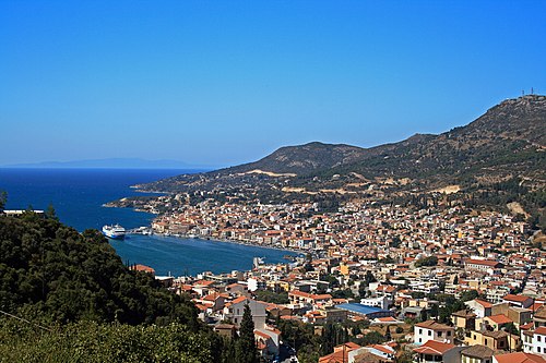
View of Samos town, capital of Samos island, Greece.


View over Livadhia - port and maint village on the island of Tilos.
Taken by Fredrik Rubensson the summer of 2006 with a Nokia N70 cameraphone / CC BY-SA 2.0

The coastal relief of Rhodes. Greece
Sources
Facts
Photographs
- Berth of fishing boats in Lefkos. Karpathos, Greece. Ввласенко / CC BY-SA 3.0
- Αστυπάλαια - Astipalea Island - panoramio. INDALOMANIA / CC BY-SA 3.0
- Colorful houses symi. Jebulon / CC0
- Samos 049 2009. Pe-sa / CC BY-SA 3.0
- Kalymnos. Unknown author / CC BY-SA 3.0
- Livadhia tilos. Taken by Fredrik Rubensson the summer of 2006 with a Nokia N70 cameraphone / CC BY-SA 2.0
- The coastal relief of Rhodes. Greece. Ввласенко / CC BY-SA 3.0