Campbell Island / Motu Ihupuku
Campbellův ostrov, Île Campbell
52°32′S 169°11′E
Campbell Island / Motu Ihupuku is an uninhabited subantarctic island of New Zealand, and the main island of the Campbell Island group. The island lies around 660 km (410 mi) south of New Zealand's South Island.

Terrain
52°32′S 169°11′E
Overview
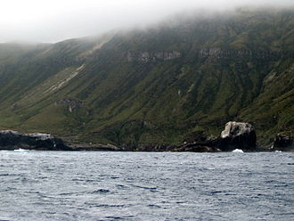
Campbell Island / Motu Ihupuku is an uninhabited subantarctic island of New Zealand, and the main island of the Campbell Island group. The island lies around 660 km (410 mi) south of New Zealand's South Island. It covers 112.68 square kilometres (43.51 sq mi) of the group's 113.31 km2 (43.75 sq mi), and is surrounded by numerous stacks, rocks and islets like Dent Island, Folly Island (or Folly Islands), Isle de Jeanette-Marie, and Jacquemart Island, the latter being the southernmost extremity of New Zealand. It is mountainous, rising to over 500 metres (1,640 ft) in the south. A long fiord, Perseverance Harbour, nearly bisects it, opening out to sea on the east coast. The island is listed with the New Zealand Outlying Islands. The island is an immediate part of New Zealand, but not part of any region or district, but instead Area Outside Territorial Authority, like all other outlying islands, other than the Solander Islands. Campbell Island was gazetted as a nature reserve in 1954, and listed as a UNESCO World Heritage Site in 1998 as part of the designation of all of the New Zealand Subantarctic Islands.
From Wikipedia, CC BY-SA 4.0
Chart
Nearest islands
- Dent Island7.8 km
- Jacquemart Island9.4 km
- Adams Island283 km
- Auckland Island295 km
- Ewing Island299 km
- Enderby Island301 km
Also in Campbell Islands

Jacquemart Island
0.23 km²▲ 127 m
Minor islands

Dent Island
0.2 km²▲ 135 m
Minor islands
Also in New Zealand Subantarctic Islands

Auckland Island
459 km²▲ 630 m
Major islands

Adams Island
96.9 km²▲ 705 m
Major islands
Antipodes Island
20.1 km²▲ 360 m
Minor islands

Enderby Island
7 km²▲ 52 m
Minor islands

Disappointment Island
2.8 km²▲ 442 m
Minor islands

North East Island
2.8 km²▲ 146 m
Minor islands
Rose Island
0.8 km²▲ 38 m
Minor islands

Ewing Island
0.58 km²▲ 23 m
Minor islands
Photographs


Scanned photo of Campbell Island landscape.

Campbell Islands Expedition, 13 Feb-3 Mar 1981, TK Crosby, GW Ramsay [Campbell I 1_02]
Department of Scientific and Industrial Research / CC BY 4.0

Campbell Island, New Zealand, one of the sub-antarctic islands of New Zealand, with a community of megaherbs in the foreground

Campbell Islands Expedition, 13 Feb-3 Mar 1981, TK Crosby, GW Ramsay [Campbell I 1_03]
Department of Scientific and Industrial Research / CC BY 4.0

Dent Island in the distance - from Campbell Island, New Zealand.

climate chart in the format by Walther and Lieth, metric, °Celsisus and millimeters, made with Geoklima 2.1

New Zealand botanist and Emeritus Professor Geoff Baylis with Chionochloa antarctica on Campbell Island, November 2000

Dracophyllum forms a medium size bush. Sheltered parts of Campbell Island, from sea level to a few hundred metres are covered with a dense scrub of Dracophyllum.

Campbell snipe (Coenocorypha aucklandica perseverance) on the boardwalk of Campbell Island, February 2017.

The buttercup species Ranunculus pinguis, photographed by Colin Meurk, on 23 December 1998, at Mt. Honey, Campbell Island, New Zealand
Sources
Facts
Photographs
- Dent Island. twiddleblat / CC BY-SA 2.0
- Campbell Island (15806194388). Archives New Zealand from New Zealand / CC BY-SA 2.0
- Campbell Island Landscape. Albatross2147 at English Wikipedia / Public domain
- Campbell I 1 02. Department of Scientific and Industrial Research / CC BY 4.0
- Campbell Island and megaherbs. twiddleblat / CC BY-SA 2.0
- Campbell I 1 03. Department of Scientific and Industrial Research / CC BY 4.0
- Dent1. L. Mead & T. Nicklin / Public domain
- Klimadiagramm-metrisch-deutsch-Campbell-Insel.Neuseeland. Hedwig in Washington / CC BY 2.5
- Geoff Baylis with Chionochloa antarctica on Campbell Island Nov 2000. Alan Mark / CC BY-SA 4.0
- Dracophyllum in Flower (463889035). twiddleblat / CC BY-SA 2.0
- Campbell snipe. Σρτ / CC BY-SA 4.0
- Ranunculus pinguis Meurk 1. Colin Meurk / CC BY-SA 4.0