Maldives
4°11′N 73°31′E
Maldives
The Maldives, officially the Republic of Maldives, and historically known as the Maldive Islands, is an archipelagic country in South Asia, located in the Indian Ocean, near the southeastern boundary of the Arabian Sea.

Chart
Overview
The Maldives, officially the Republic of Maldives, and historically known as the Maldive Islands, is an archipelagic country in South Asia, located in the Indian Ocean, near the southeastern boundary of the Arabian Sea. The Maldives is located southwest of India and Sri Lanka, about 750 kilometres (470 miles; 400 nautical miles) from the Asian continent's mainland. The Maldives' chain of 26 atolls stretches across the equator from Ihavandhippolhu Atoll in the north to Addu Atoll in the south. Malé is the capital and the most populated city, traditionally called the "King's Island", where the ancient royal dynasties ruled from its central location. The Maldives has been inhabited for over 2,500 years. Documented contact with the outside world began around 947 CE when Arab travellers began visiting the islands. In the 12th century, partly due to the importance of the Arabs and Persians as traders in the Indian Ocean, Islam reached the Maldivian Archipelago. The Maldives was soon consolidated as a sultanate, developing strong commercial and cultural ties with Asia and Africa. From the mid-16th century, the region came under the increasing influence of European colonial powers, with the Maldives becoming a British protectorate in 1887. Independence from the United Kingdom came in 1965, and a presidential republic was established in 1968 with an elected People's Majlis. The ensuing decades have seen political instability, efforts at democratic reform, and environmental challenges posed by climate change and rising sea levels. The Maldives is the smallest country in Asia. Its land area is only 298 square kilometres (115 sq mi), but this is spread over roughly 90,000 square kilometres (35,000 sq mi) of the sea, making it one of the world's most spatially dispersed sovereign states. With a population of 515,132 in the 2022 census, it is the second least populous country in Asia and the ninth-smallest country by area, but also one of the most densely populated countries. The Maldives has an average ground-level elevation of around 1.5 metres (4 ft 11 in) above sea level, and a highest natural point of only 2.4 metres (7 ft 10 in), making it the world's lowest-lying country. Some sources state the highest point, Mount Villingili, as 5.1 metres or 17 feet. Fishing has historically been the dominant economic activity, and remains the second largest sector, behind the rapidly growing tourism industry. The Maldives rates "high" on the Human Development Index, with a per capita income significantly higher than other SAARC nations. The World Bank classifies the Maldives as having an upper-middle income economy. The Maldives is a member of the United Nations, the Commonwealth of Nations, the Organisation of Islamic Cooperation, and the Non-Aligned Movement, and is a Dialogue Partner of the Shanghai Cooperation Organisation. It became a founding member of the South Asian Association for Regional Cooperation (SAARC). The Maldives temporarily withdrew from the Commonwealth in October 2016 over concerns of situation of human rights and democracy in the country, but was readmitted to the Commonwealth on 1 February 2020 after showing evidence of reform and functioning democratic processes.
From Wikipedia, CC BY-SA 4.0
Census, cataloged
- Major islands254
- Minor islands269
- Islets845
- Rocks & skerries52
Major islands
Hithadhoo
- Area
- 6.7 km²
- High point
- 15 m
Fuvahmulah
- Area
- 5 km²
- High point
- 15 m
Fuvahmulah (Dhivehi: ފުވައްމުލައް) is an island (atoll) in the Maldives. It is under Maldives' administrative division of Gnaviyani (or Nyaviyani) Atoll. The island is the second southernmost administrative atoll, located to the south of Huvadhu Atoll and to the north of Seenu Atoll.
Hulhumalé
- Area
- 4.9 km²
- High point
- 12 m
Hulhumalé (Dhivehi pronunciation: [huɭumɑːlɛ]; Dhivehi: ހުޅުމާލެ) is a reclaimed island located in the south of North Malé Atoll, Maldives.
Hulhulé
- Area
- 3.3 km²
- High point
- 7 m
Hulhulé (Dhivehi: ހުޅުލެ), located at 4°11′N 73°32′E, is an island in the North Malé Atoll of the Maldives where the city's airport, Velana International Airport, is located. The island has no permanent population.
Hulhumeedhoo
- Area
- 3.2 km²
- High point
- 10 m
Hanimaadhoo
- Area
- 3.2 km²
- High point
- 17 m
Hanimaadhoo (Dhivehi: ހަނިމާދޫ) is one of the inhabited islands of Haa Dhaalu Atoll administrative division and geographically part of Thiladhummathi Atoll in the north of the Maldives.
Thilafushi
- Area
- 2.4 km²
- High point
- 10 m
Thilafushi (Dhivehi: ތިލަފުށި) is an artificial island in the Maldives, created by a government decision in 1991 as a municipal landfill situated to the west of the capital, Malé. It is located between Kaafu Atoll's Giraavaru and Gulhifalhu.
Maamigili
- Area
- 2.1 km²
- High point
- 16 m
Male Island
- Area
- 2.1 km²
- High point
- 18 m
Kelaa
- Area
- 2 km²
- High point
- 20 m
Kaadedhdhoo
- Area
- 1.8 km²
- High point
- 13 m
Thoddoo
- Area
- 1.6 km²
- High point
- 17 m
Thoddoo (Dhivehi: ތޮއްޑޫ) is one of the inhabited islands of Alif Alif Atoll in the Republic of Maldives.
Hithadhoo
- Area
- 1.2 km²
- High point
- 19 m
Naifaru
- Area
- 1.1 km²
- High point
- 6 m
Naifaru (Dhivehi: ނައިފަރު) is an island in the Maldives 144 km (89 mi) north of the capital, Malé. It is the capital and most populous island of Lhaviyani Atoll.
Hondaafushi
- Area
- 0.64 km²
- High point
- 10 m
Hulhudhuffaaru
- Area
- 0.61 km²
- High point
- 16 m
Fainu
- Area
- 0.6 km²
- High point
- 17 m
Maafilaafushi
- Area
- 0.58 km²
- High point
- 19 m
Maafilaafushi (Dhivehi: މާފިލާފުށި) is one of the uninhabited islands of Lhaviyani Atoll in the Maldives.
Nalaguraidhoo
- Area
- 0.54 km²
- High point
- 14 m
Huraa
- Area
- 0.52 km²
- High point
- 11 m
Ungoofaaru
- Area
- 0.51 km²
- High point
- 9 m
Utheemu
- Area
- 0.49 km²
- High point
- 16 m
Inguraidhoo
- Area
- 0.46 km²
- High point
- 12 m
Maafushi
- Area
- 0.43 km²
- High point
- 7 m
Maafushi (Dhivehi: މާފުށި) is one of the inhabited islands of Kaafu Atoll in the Maldives.
Vashafaru
- Area
- 0.35 km²
- High point
- 12 m
Meeru Island
- Area
- 0.34 km²
- High point
- 17 m
Meeru Island (also known as Meerufenfushi) is an island on the easternmost tip of North Malé Atoll (Kaafu Atoll) in the Maldives. It is located South West of Sri Lanka on the equator, some 50 kilometres from the capital Male'.


Unnamed island
- Area
- 10.2 km²
- High point
- 17 m
Gan
- Area
- 7.1 km²
- High point
- 21 m
Unnamed island
- Area
- 6 km²
- High point
- 16 m
Unnamed island
- Area
- 5.3 km²
- High point
- 1 m
Isdhoo
- Area
- 3.7 km²
- High point
- 19 m
Gan
- Area
- 3.3 km²
- High point
- 15 m
Gan (Dhivehi: ގަން) is the southernmost island of Addu Atoll (also known as Seenu Atoll), as well as the southernmost island of the Maldives. It is relatively large by Maldive standards.
Kaashidhoo
- Area
- 2.8 km²
- High point
- 17 m
Kaashidhoo (Dhivehi: ކާށިދޫ) is one of the inhabited islands of Kaafu Atoll, Maldives.
Filladhoo
- Area
- 2.7 km²
- High point
- 18 m
Kulhudhuffushi
- Area
- 2.5 km²
- High point
- 15 m
Baarah
- Area
- 2.5 km²
- High point
- 19 m
Baarah (Dhivehi: ބާރަށް) is an inhabited island in Haa Alif Atoll in the northern Maldives. It is an island-level administrative constituency governed by the Baarah Island Council.
Gan
- Area
- 2.4 km²
- High point
- 17 m
Unnamed island
- Area
- 2.2 km²
Unnamed island
- Area
- 2.1 km²
Dhidhdhoo
- Area
- 2.1 km²
- High point
- 8 m
Gulhifalhu
- Area
- 2.1 km²
- High point
- 2 m
Gulhifalhu (Dhivehi: ގުޅިފަޅު), also Gulhi Falhu, is an artificial island and a district of Malé City, Maldives. Located between Villingili (Villimalé) and Thilafushi, Gulhifalhu will be connected to its neighbors and central Malé (6 km away) by the Thilamalé Bridge, which is scheduled for completion in 2027.
Nolhivaram
- Area
- 2 km²
- High point
- 26 m
Kendhikulhudhoo
- Area
- 2 km²
- High point
- 20 m
Unnamed island
- Area
- 1.9 km²
Kumundhoo
- Area
- 1.9 km²
- High point
- 25 m
Thinadhoo
- Area
- 1.9 km²
- High point
- 9 m
Fonadhoo
- Area
- 1.7 km²
- High point
- 19 m
Nolhivaranfaru
- Area
- 1.7 km²
- High point
- 20 m
Maradhoo
- Area
- 1.7 km²
- High point
- 9 m
Maradhoo (Dhivehi: މަރަދޫ) is one of the inhabited islands of the Addu Atoll (also known as Seenu Atoll).
Neykurendhoo
- Area
- 1.7 km²
- High point
- 20 m
Kudahuvadhoo
- Area
- 1.7 km²
- High point
- 17 m
Horsburgh Atoll
- Area
- 1.6 km²
- High point
- 19 m
Unnamed island
- Area
- 1.6 km²
Milandhoo
- Area
- 1.5 km²
- High point
- 16 m
Giraavaru
- Area
- 1.5 km²
Giraavaru is an island of Malé Atoll (the administrative Kaafu Atoll) nowadays hosting a tourist resort. It is located on the southwestern fringe of the lagoon of North Malé Atoll. It was inhabited in the past by the community known as Giraavaru people (or Tivaru people).
Maafaru
- Area
- 1.3 km²
- High point
- 15 m
Hoandedhdhoo
- Area
- 1.2 km²
- High point
- 16 m
Funadhoo
- Area
- 1.2 km²
- High point
- 16 m
Vashahéra
- Area
- 1.2 km²
- High point
- 12 m
Mulhadhoo
- Area
- 1.2 km²
- High point
- 18 m
Kondey
- Area
- 1.2 km²
- High point
- 16 m
Finey
- Area
- 1.2 km²
- High point
- 23 m
Unnamed island
- Area
- 1.2 km²
Muli
- Area
- 1.2 km²
- High point
- 15 m
Muli (Dhivehi: މުލި) is the capital of Meemu Atoll, which is an administrative division of the Maldives.
Hoarafushi
- Area
- 1.1 km²
- High point
- 12 m
Manadhoo
- Area
- 1.1 km²
- High point
- 24 m
Kaadedhdhoo
- Area
- 1.1 km²
- High point
- 18 m
Villingili
- Area
- 1.1 km²
- High point
- 6 m
Uligan
- Area
- 1.1 km²
- High point
- 18 m
Vaikaradhoo
- Area
- 1.1 km²
- High point
- 21 m
Unnamed island
- Area
- 1 km²
- High point
- 17 m
Goidhoo
- Area
- 1 km²
- High point
- 21 m
Thimarafushi
- Area
- 1 km²
- High point
- 12 m
Thimarafushi (Dhivehi: ތިމަރަފުށި) is one of the inhabited islands in Thaa Atoll of the Maldives.
Kunahandhoo
- Area
- 0.99 km²
- High point
- 15 m
Mahafai
- Area
- 0.99 km²
- High point
- 13 m
Kalhufahalafushi
- Area
- 0.99 km²
- High point
- 14 m
Maavarulu
- Area
- 0.95 km²
- High point
- 14 m
Kolhufushi
- Area
- 0.95 km²
- High point
- 21 m
Kolhufushi is an inhabited island off the southwest coast of Meemu Atoll or Mulaku Atoll. It is the third most populous island in Meemu Atoll.
Landhoo
- Area
- 0.92 km²
- High point
- 17 m
Ekasdhoo
- Area
- 0.92 km²
- High point
- 15 m
Feevah
- Area
- 0.91 km²
- High point
- 15 m
Kanditheemu
- Area
- 0.91 km²
- High point
- 20 m
Keylakunu
- Area
- 0.91 km²
- High point
- 24 m
Feydhoo
- Area
- 0.9 km²
- High point
- 23 m
Maakandoodhoo
- Area
- 0.89 km²
- High point
- 12 m
Ihavandhoo
- Area
- 0.89 km²
- High point
- 18 m
Magoodhoo
- Area
- 0.85 km²
- High point
- 16 m
Kandoodhoo
- Area
- 0.83 km²
- High point
- 20 m
Kandoodhoo (Dhivehi: ކަނޑޫދޫ) is one of the inhabited islands of Thaa Atoll.
ދިއްފުށިމާދޫ
- Area
- 0.82 km²
- High point
- 12 m
Kooddoo
- Area
- 0.8 km²
- High point
- 15 m
Fiyoaree
- Area
- 0.79 km²
- High point
- 15 m
Naagoashi
- Area
- 0.77 km²
- High point
- 10 m
Makunudhoo
- Area
- 0.76 km²
- High point
- 13 m
Makunudhoo (Dhivehi: މަކުނުދޫ) is one of the inhabited islands of Haa Dhaalu Atoll administrative division and geographically part of Māmakunudhoo Atoll (Malcolm Atoll) in the north of the Maldives. It is the westernmost inhabited island in the Maldives.
Thulusdhoo
- Area
- 0.76 km²
- High point
- 11 m
Veymandoo
- Area
- 0.75 km²
- High point
- 15 m
Veymandoo (Dhivehi: ވޭމަންޑޫ) is the capital of Thaa Atoll in the Maldives.
Unnamed island
- Area
- 0.75 km²
Gaadhoo
- Area
- 0.74 km²
- High point
- 21 m
Nilandhoo
- Area
- 0.73 km²
- High point
- 17 m
Farukolhu
- Area
- 0.73 km²
- High point
- 12 m
Mulah
- Area
- 0.71 km²
- High point
- 18 m
Mulah (Dhivehi: މުލައް) or Boli Mulah is one of the inhabited islands of Meemu Atoll.
Kanimeedhoo
- Area
- 0.69 km²
- High point
- 17 m
Medhoo
- Area
- 0.69 km²
- High point
- 17 m
Vaikaramuraidhoo
- Area
- 0.68 km²
- High point
- 16 m
Berasdhoo
- Area
- 0.68 km²
- High point
- 18 m
Mulidhoo
- Area
- 0.68 km²
- High point
- 16 m
Bileffahi
- Area
- 0.67 km²
- High point
- 21 m
Dharavandhoo
- Area
- 0.67 km²
- High point
- 14 m
Foakaidhoo
- Area
- 0.66 km²
- High point
- 19 m
Kinbidhoo
- Area
- 0.65 km²
- High point
- 18 m
Kinbidhoo (Dhivehi: ކިނބިދޫ) is one of the inhabited islands of Thaa Atoll. In the order of the inhabited islands, Kinbidhoo is the 12th island and the island code is N-12. Post code for the island is 14120.
Himmafushi
- Area
- 0.65 km²
- High point
- 14 m
Unnamed island
- Area
- 0.64 km²
- High point
- 11 m
Velidhoo
- Area
- 0.64 km²
- High point
- 10 m
Fainuaadhamhuraa
- Area
- 0.62 km²
- High point
- 14 m
Alifushi
- Area
- 0.61 km²
- High point
- 16 m
Alifushi (Dhivehi: އަލިފުށި) is an inhabited island in the Northern Maldives, administratively part of Raa Atoll (Northern Maalhosmadulu). Located isolated at the northernmost point of the atoll, it forms a small distinct geographic feature alongside its neighboring, uninhabited paired islet, Etthingili.
Nilandhoo
- Area
- 0.6 km²
- High point
- 14 m
Vilufushi
- Area
- 0.59 km²
- High point
- 11 m
Vilufushi (Dhivehi: ވިލުފުށި) is an inhabited island in Maldives.
Heréthéré
- Area
- 0.59 km²
- High point
- 6 m
Unnamed island
- Area
- 0.59 km²
- High point
- 13 m
Maamendhoo
- Area
- 0.59 km²
- High point
- 16 m
Unnamed island
- Area
- 0.58 km²
Gadhdhoo
- Area
- 0.58 km²
- High point
- 7 m
Gemanafushi
- Area
- 0.58 km²
- High point
- 11 m
Theefaridhoo
- Area
- 0.56 km²
- High point
- 17 m
Dhanbidhoo
- Area
- 0.56 km²
- High point
- 18 m
Kinolhas
- Area
- 0.56 km²
- High point
- 17 m
Dhigurah
- Area
- 0.55 km²
- High point
- 16 m
Ifuru
- Area
- 0.55 km²
- High point
- 15 m
Dhuvaafaru
- Area
- 0.55 km²
- High point
- 7 m
Unnamed island
- Area
- 0.54 km²
Hinnavaru
- Area
- 0.53 km²
- High point
- 6 m
Hinnavaru (Dhivehi: ހިންނަވަރު) is one of the inhabited islands of Lhaviyani Atoll. The island has a population of more than 5000 people.
Dhigurah
- Area
- 0.53 km²
- High point
- 10 m
Unnamed island
- Area
- 0.53 km²
- High point
- 8 m
Eydhafushi
- Area
- 0.53 km²
- High point
- 17 m
Maabaidhoo
- Area
- 0.53 km²
- High point
- 18 m
Felivaru
- Area
- 0.52 km²
- High point
- 15 m
Maavah
- Area
- 0.52 km²
- High point
- 16 m
Madifushi
- Area
- 0.52 km²
- High point
- 16 m
Madifushi (Dhivehi: މަޑިފުށި) is one of the inhabited islands of Thaa Atoll.
Unnamed island
- Area
- 0.51 km²
- High point
- 10 m
Reethi Rah
- Area
- 0.5 km²
- High point
- 10 m
Kunburudhoo
- Area
- 0.5 km²
- High point
- 21 m
Hirinaidhoo
- Area
- 0.49 km²
- High point
- 13 m
Huvahandhoo
- Area
- 0.49 km²
- High point
- 15 m
Medhufaru
- Area
- 0.49 km²
- High point
- 8 m
Muraidhoo
- Area
- 0.48 km²
- High point
- 19 m
Nadellaa
- Area
- 0.48 km²
- High point
- 15 m
Maakurathu
- Area
- 0.48 km²
- High point
- 15 m
Unnamed island
- Area
- 0.47 km²
- High point
- 12 m
Hirimaradhoo
- Area
- 0.47 km²
- High point
- 17 m
Madaveli
- Area
- 0.46 km²
- High point
- 14 m
Unnamed island
- Area
- 0.46 km²
- High point
- 13 m
Unnamed island
- Area
- 0.46 km²
- High point
- 9 m
Medhukuburudhoo
- Area
- 0.46 km²
- High point
- 15 m
Dhiyadhoo
- Area
- 0.46 km²
- High point
- 17 m
Feridhoo
- Area
- 0.46 km²
- High point
- 14 m
Unnamed island
- Area
- 0.46 km²
- High point
- 16 m
Veyvah
- Area
- 0.45 km²
- High point
- 21 m
Veyvah (Dhivehi: ވޭވައް) is one of the inhabited islands of Meemu Atoll.
Dhiggaru
- Area
- 0.45 km²
- High point
- 7 m
Dhiggaru (Dhivehi: ދިއްގަރު) is one of the inhabited islands of Meemu Atoll in the Maldives.
Unnamed island
- Area
- 0.45 km²
- High point
- 12 m
Lhaimagu
- Area
- 0.45 km²
- High point
- 17 m
Fares Maathodaa
- Area
- 0.44 km²
- High point
- 10 m
Maarandhoo
- Area
- 0.44 km²
- High point
- 19 m
Kunfunadhoo
- Area
- 0.44 km²
- High point
- 17 m
Vattaru
- Area
- 0.43 km²
- High point
- 11 m
Unnamed island
- Area
- 0.43 km²
- High point
- 12 m
Thakandhoo
- Area
- 0.43 km²
- High point
- 17 m
Narudhoo
- Area
- 0.43 km²
- High point
- 16 m
Thulhaadhoo
- Area
- 0.42 km²
- High point
- 6 m
Lhohi
- Area
- 0.42 km²
- High point
- 20 m
Kurinbi
- Area
- 0.41 km²
- High point
- 16 m
Maavaidhoo
- Area
- 0.41 km²
- High point
- 17 m
Maabinhuraa
- Area
- 0.41 km²
- High point
- 14 m
Kotafuri
- Area
- 0.41 km²
- High point
- 15 m
Kuredu Island
- Area
- 0.41 km²
- High point
- 12 m
Angolhitheemu
- Area
- 0.4 km²
- High point
- 17 m
Dharanboodhoo
- Area
- 0.4 km²
- High point
- 17 m
Unnamed island
- Area
- 0.4 km²
Noomaraa
- Area
- 0.39 km²
- High point
- 21 m
Rasgetheemu
- Area
- 0.39 km²
- High point
- 19 m
Maalhendhoo
- Area
- 0.39 km²
- High point
- 17 m
Mandhoo
- Area
- 0.39 km²
- High point
- 17 m
Kudakurathu
- Area
- 0.39 km²
- High point
- 10 m
Rathafandhoo
- Area
- 0.38 km²
- High point
- 12 m
Unnamed island
- Area
- 0.38 km²
- High point
- 10 m
Unnamed island
- Area
- 0.38 km²
- High point
- 12 m
Unnamed island
- Area
- 0.38 km²
Guraidhoo
- Area
- 0.38 km²
- High point
- 11 m
Guraidhoo (Dhivehi: ގުރައިދޫ) is one of the inhabited islands of Kaafu Atoll in the Maldives.
Vaadhoo
- Area
- 0.38 km²
- High point
- 14 m
Madivaru
- Area
- 0.38 km²
- High point
- 14 m
Maalhos
- Area
- 0.38 km²
- High point
- 18 m
Unnamed island
- Area
- 0.37 km²
- High point
- 7 m
Unnamed island
- Area
- 0.37 km²
- High point
- 15 m
Magoodhoo
- Area
- 0.36 km²
- High point
- 16 m
Omadhoo
- Area
- 0.36 km²
- High point
- 19 m
Omadhoo (Dhivehi: އޮމަދޫ) is one of the inhabited islands of Thaa Atoll.
Burunee
- Area
- 0.36 km²
- High point
- 17 m
Burunee (Dhivehi: ބުރުނީ) is one of the inhabited islands of Thaa Atoll.
Innamaadhoo
- Area
- 0.35 km²
- High point
- 16 m
Maamaduvvari
- Area
- 0.35 km²
- High point
- 15 m
Kolamaafushi
- Area
- 0.35 km²
- High point
- 11 m
Meedhoo
- Area
- 0.35 km²
- High point
- 12 m
Unnamed island
- Area
- 0.34 km²
- High point
- 11 m
Rocks & skerries
On the chart above, at its closest zooms.
Listing 200 of 1420; the rest are on the chart.
Figures
Comparative heights
- Nolhivaram: 26 m
- Kumundhoo: 25 m
- Manadhoo: 24 m
- Keylakunu: 24 m
- Finey: 23 m
- Feydhoo: 23 m
- Gan: 21 m
- Vaikaradhoo: 21 m
- Goidhoo: 21 m
- Kolhufushi: 21 m
- Gaadhoo: 21 m
- Bileffahi: 21 m
- Kunburudhoo: 21 m
- Veyvah: 21 m
To the same scale
Islands by area
| Unnamed island | 10.2 km² |
| Gan | 7.1 km² |
| Hithadhoo | 6.7 km² |
| Unnamed island | 6 km² |
| Unnamed island | 5.3 km² |
| Fuvahmulah | 5 km² |
| Hulhumalé | 4.9 km² |
| Isdhoo | 3.7 km² |
| Gan | 3.3 km² |
| Hulhulé | 3.3 km² |
| Hulhumeedhoo | 3.2 km² |
| Hanimaadhoo | 3.2 km² |
| Kaashidhoo | 2.8 km² |
| Filladhoo | 2.7 km² |
| Kulhudhuffushi | 2.5 km² |
| Baarah | 2.5 km² |
| Gan | 2.4 km² |
| Thilafushi | 2.4 km² |
| Unnamed island | 2.2 km² |
| Unnamed island | 2.1 km² |
| Dhidhdhoo | 2.1 km² |
| Gulhifalhu | 2.1 km² |
| Maamigili | 2.1 km² |
| Male Island | 2.1 km² |
| Nolhivaram | 2 km² |
| Kelaa | 2 km² |
| Kendhikulhudhoo | 2 km² |
| Unnamed island | 1.9 km² |
| Kumundhoo | 1.9 km² |
| Thinadhoo | 1.9 km² |
| Kaadedhdhoo | 1.8 km² |
| Fonadhoo | 1.7 km² |
| Nolhivaranfaru | 1.7 km² |
| Maradhoo | 1.7 km² |
| Neykurendhoo | 1.7 km² |
| Kudahuvadhoo | 1.7 km² |
| Horsburgh Atoll | 1.6 km² |
| Thoddoo | 1.6 km² |
| Unnamed island | 1.6 km² |
| Milandhoo | 1.5 km² |
| Giraavaru | 1.5 km² |
| Maafaru | 1.3 km² |
| Hithadhoo | 1.2 km² |
| Hoandedhdhoo | 1.2 km² |
| Funadhoo | 1.2 km² |
| Vashahéra | 1.2 km² |
| Mulhadhoo | 1.2 km² |
| Kondey | 1.2 km² |
| Finey | 1.2 km² |
| Unnamed island | 1.2 km² |
| Muli | 1.2 km² |
| Hoarafushi | 1.1 km² |
| Manadhoo | 1.1 km² |
| Kaadedhdhoo | 1.1 km² |
| Villingili | 1.1 km² |
| Uligan | 1.1 km² |
| Naifaru | 1.1 km² |
| Vaikaradhoo | 1.1 km² |
| Unnamed island | 1 km² |
| Goidhoo | 1 km² |
| Thimarafushi | 1 km² |
| Kunahandhoo | 0.99 km² |
| Mahafai | 0.99 km² |
| Kalhufahalafushi | 0.99 km² |
| Maavarulu | 0.95 km² |
| Kolhufushi | 0.95 km² |
| Landhoo | 0.92 km² |
| Ekasdhoo | 0.92 km² |
| Feevah | 0.91 km² |
| Kanditheemu | 0.91 km² |
| Keylakunu | 0.91 km² |
| Feydhoo | 0.9 km² |
| Maakandoodhoo | 0.89 km² |
| Ihavandhoo | 0.89 km² |
| Magoodhoo | 0.85 km² |
| Kandoodhoo | 0.83 km² |
| ދިއްފުށިމާދޫ | 0.82 km² |
| Kooddoo | 0.8 km² |
| Fiyoaree | 0.79 km² |
| Naagoashi | 0.77 km² |
| Makunudhoo | 0.76 km² |
| Thulusdhoo | 0.76 km² |
| Veymandoo | 0.75 km² |
| Unnamed island | 0.75 km² |
| Gaadhoo | 0.74 km² |
| Nilandhoo | 0.73 km² |
| Farukolhu | 0.73 km² |
| Mulah | 0.71 km² |
| Kanimeedhoo | 0.69 km² |
| Medhoo | 0.69 km² |
| Vaikaramuraidhoo | 0.68 km² |
| Berasdhoo | 0.68 km² |
| Mulidhoo | 0.68 km² |
| Bileffahi | 0.67 km² |
| Dharavandhoo | 0.67 km² |
| Foakaidhoo | 0.66 km² |
| Kinbidhoo | 0.65 km² |
| Himmafushi | 0.65 km² |
| Unnamed island | 0.64 km² |
| Hondaafushi | 0.64 km² |
| Velidhoo | 0.64 km² |
| Fainuaadhamhuraa | 0.62 km² |
| Hulhudhuffaaru | 0.61 km² |
| Alifushi | 0.61 km² |
| Fainu | 0.6 km² |
| Nilandhoo | 0.6 km² |
| Vilufushi | 0.59 km² |
| Heréthéré | 0.59 km² |
| Unnamed island | 0.59 km² |
| Maamendhoo | 0.59 km² |
| Unnamed island | 0.58 km² |
| Gadhdhoo | 0.58 km² |
| Maafilaafushi | 0.58 km² |
| Gemanafushi | 0.58 km² |
| Theefaridhoo | 0.56 km² |
| Dhanbidhoo | 0.56 km² |
| Kinolhas | 0.56 km² |
| Dhigurah | 0.55 km² |
| Ifuru | 0.55 km² |
| Dhuvaafaru | 0.55 km² |
| Unnamed island | 0.54 km² |
| Nalaguraidhoo | 0.54 km² |
| Hinnavaru | 0.53 km² |
| Dhigurah | 0.53 km² |
| Unnamed island | 0.53 km² |
| Eydhafushi | 0.53 km² |
| Maabaidhoo | 0.53 km² |
| Huraa | 0.52 km² |
| Felivaru | 0.52 km² |
| Maavah | 0.52 km² |
| Madifushi | 0.52 km² |
| Villingili | 0.52 km² |
| Unnamed island | 0.51 km² |
| Ungoofaaru | 0.51 km² |
| Reethi Rah | 0.5 km² |
| Kunburudhoo | 0.5 km² |
| Hirinaidhoo | 0.49 km² |
| Huvahandhoo | 0.49 km² |
| Medhufaru | 0.49 km² |
| Utheemu | 0.49 km² |
| Muraidhoo | 0.48 km² |
| Nadellaa | 0.48 km² |
| Maakurathu | 0.48 km² |
| Unnamed island | 0.47 km² |
| Hirimaradhoo | 0.47 km² |
| Madaveli | 0.46 km² |
| Unnamed island | 0.46 km² |
| Unnamed island | 0.46 km² |
| Medhukuburudhoo | 0.46 km² |
| Inguraidhoo | 0.46 km² |
| Dhiyadhoo | 0.46 km² |
| Feridhoo | 0.46 km² |
| Unnamed island | 0.46 km² |
| Veyvah | 0.45 km² |
| Dhiggaru | 0.45 km² |
| Unnamed island | 0.45 km² |
| Lhaimagu | 0.45 km² |
| Fares Maathodaa | 0.44 km² |
| Maarandhoo | 0.44 km² |
| Kunfunadhoo | 0.44 km² |
| Vattaru | 0.43 km² |
| Unnamed island | 0.43 km² |
| Thakandhoo | 0.43 km² |
| Narudhoo | 0.43 km² |
| Maafushi | 0.43 km² |
| Thulhaadhoo | 0.42 km² |
| Lhohi | 0.42 km² |
| Kurinbi | 0.41 km² |
| Maavaidhoo | 0.41 km² |
| Maabinhuraa | 0.41 km² |
| Kotafuri | 0.41 km² |
| Kuredu Island | 0.41 km² |
| Angolhitheemu | 0.4 km² |
| Dharanboodhoo | 0.4 km² |
| Unnamed island | 0.4 km² |
| Noomaraa | 0.39 km² |
| Rasgetheemu | 0.39 km² |
| Maalhendhoo | 0.39 km² |
| Mandhoo | 0.39 km² |
| Kudakurathu | 0.39 km² |
| Rathafandhoo | 0.38 km² |
| Unnamed island | 0.38 km² |
| Unnamed island | 0.38 km² |
| Unnamed island | 0.38 km² |
| Guraidhoo | 0.38 km² |
| Vaadhoo | 0.38 km² |
| Madivaru | 0.38 km² |
| Maalhos | 0.38 km² |
| Unnamed island | 0.37 km² |
| Unnamed island | 0.37 km² |
| Magoodhoo | 0.36 km² |
| Omadhoo | 0.36 km² |
| Burunee | 0.36 km² |
| Innamaadhoo | 0.35 km² |
| Maamaduvvari | 0.35 km² |
| Kolamaafushi | 0.35 km² |
| Meedhoo | 0.35 km² |
| Vashafaru | 0.35 km² |
| Unnamed island | 0.34 km² |
| Meeru Island | 0.34 km² |
Groups within
Overlapping groups
Photographs
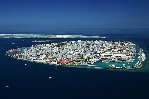
Malé, capital of Maldives

Fuvahmulah Kedeyre Miskiy

Hithadhoo Road side, The Island Nation

Children's Day Festival in G.A.Gemanafushi

Children's Day Festival in G.A.Gemanafushi
Sources
Facts
Photographs
- Male-total. Shahee Ilyas / CC BY-SA 3.0
- Fuvahmulah Kedeyre Miskiy - panoramio. Ibrahim Asad / CC BY 3.0
- Hithadhoo Road side, The Island Nation - panoramio. Ibrahim Asad / CC BY 3.0
- Children's Day Festival in G.A.Gemanafushi (431). The President's Office, Maldives / CC BY 4.0
- Children's Day Festival in G.A.Gemanafushi (437). The President's Office, Maldives / CC BY 4.0
- Maldives banner Small island shoreline with beach. Steevie / CC0