Hulhumalé
ހުޅުމާލެ, Hulhumale
4°14′N 73°33′E
Hulhumalé (Dhivehi pronunciation: [huɭumɑːlɛ]; Dhivehi: ހުޅުމާލެ) is a reclaimed island located in the south of North Malé Atoll, Maldives.

Terrain
4°14′N 73°33′E
Overview
Hulhumalé (Dhivehi pronunciation: [huɭumɑːlɛ]; Dhivehi: ހުޅުމާލެ) is a reclaimed island located in the south of North Malé Atoll, Maldives. The artificial island is being built up by pumping sand from the sea floor, in order to meet the existing and future housing, industrial and commercial development demands of the Malé region and as a response to the threat posed by rising sea levels. The official settlement was inaugurated by President Maumoon Abdul Gayoom on May 12, 2004. The development and management of the island is undertaken by a government-owned corporation called Housing Development Corporation (formerly Hulhumalé Development Unit and Urbanco), incorporated on March 23, 2005. Land reclamation has increased the island's area to 4 km2 (1.5 sq mi), making it the fourth largest island in the Maldives. As of December 2019 the island has a population of more than 50,000; it is planned to house as many as 240,000 by the mid-2020s.
From Wikipedia, CC BY-SA 4.0
Chart
Nearest islands
- Hulhulé5.3 km
- Male Island7.1 km
- Himmafushi9.3 km
- Gulhifalhu9.7 km
- Thilafushi15 km
- Giraavaru16 km
Also in North Malé Atoll
Unnamed island
5.3 km²▲ 1 m
Major islands

Hulhulé
3.3 km²▲ 7 m
Major islands

Thilafushi
2.4 km²▲ 10 m
Major islands
Gulhifalhu
2.1 km²▲ 2 m
Major islands

Male Island
2.1 km²▲ 18 m
Major islands
Giraavaru
1.5 km²
Major islands
Thulusdhoo
0.76 km²▲ 11 m
Major islands
Himmafushi
0.65 km²▲ 14 m
Major islands
Also in Maldives
Unnamed island
10.2 km²▲ 17 m
Major islands
Gan
7.1 km²▲ 21 m
Major islands

Hithadhoo
6.7 km²▲ 15 m
Major islands
Unnamed island
6 km²▲ 16 m
Major islands
Unnamed island
5.3 km²▲ 1 m
Major islands

Fuvahmulah
5 km²▲ 15 m
Major islands
Isdhoo
3.7 km²▲ 19 m
Major islands
Gan
3.3 km²▲ 15 m
Major islands
Photographs
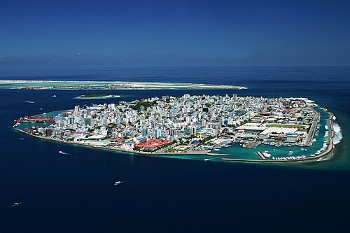
Malé, capital of Maldives

Es handelt sich hierbei um Hulhumale, einem Teil des Male Airport Aufnahmeort: In der Luft

Hulhumalé, Maldives photographed from a Plane

Hulhumalé, Maldives photographed from a Plane

swing

Apartment Blocks - Hulhumale - Maldives

Architecture - Hulhumale - Maldives

Detail of Apartment Blocks - Hulhumale - Maldives

Beach side amenities at Hulhumale

Thats Hulhumale view at sunrise from Hulhule

Hulhumalé, Maldives

Hulhumalé, Maldives
Sources
Facts
Photographs
- Male-total. Shahee Ilyas / CC BY-SA 3.0
- XMaleairport. M.Huwyler / CC BY-SA 3.0
- Malediven Rückflug Hulhumale 2. Zairon / CC BY-SA 4.0
- Malediven Rückflug Hulhumale 1. Zairon / CC BY-SA 4.0
- Swing Hulhumale Beach-Maldives-Andres Larin. Saaremees / CC BY-SA 4.0
- Apartment Blocks - Hulhumale - Maldives (14111148798). Adam Jones from Kelowna, BC, Canada / CC BY-SA 2.0
- Architecture - Hulhumale - Maldives (14295830842). Adam Jones from Kelowna, BC, Canada / CC BY-SA 2.0
- Detail of Apartment Blocks - Hulhumale - Maldives (14295828132). Adam Jones from Kelowna, BC, Canada / CC BY-SA 2.0
- Hulhumale beach 2018-03-17. FaysaLBinDaruL / CC BY-SA 4.0
- Sunrise 24th June 2007-Hulhumale (612289154). ╚ DD╔ from Male, Maldives / CC BY-SA 2.0
- Colorblindness. (Unsplash). Ameen Fahmy ameenfahmy_ / CC0
- Hulhumalé, Maldives - panoramio. goldpicasa / CC BY 3.0