Indian OceanMaldives
3°52′N 72°50′E
Ari Atoll
Part of Maldives
Ari Atoll (also called Alif or Alifu Atoll) is one of the natural atolls of the Maldives. It is one of the biggest atolls and is located in the west of the archipelago. 9 miles). It has been divided in two sections for administrative purposes, Northern Ari Atoll and Southern Ari Atoll consisting of 105 islands.

Chart
Overview
Ari Atoll (also called Alif or Alifu Atoll) is one of the natural atolls of the Maldives. It is one of the biggest atolls and is located in the west of the archipelago. The almost rectangular alignment spreads the islands over an area of about 89 by 3 kilometres (55.3 by 1.9 miles). It has been divided in two sections for administrative purposes, Northern Ari Atoll and Southern Ari Atoll consisting of 105 islands. Ari Atoll is part of the zone designated for tourist development in the Maldives. It is roughly a 30-minute seaplane flight away from the capital Malé. There are more than 20 islands in the Atoll designated for tourist resorts. Each island resort is self-contained with accommodation and recreational facilities, such as a tennis court. Scuba diving is the most popular tourist activity in the Maldives. The diving in Ari Atoll is extensive and is often defined by location within the atoll, either North or South. The main tourist resorts are Ari Beach, Halaveli, Maayyafushi, Twin Islands Resort, and Dhoni Mighilli.
From Wikipedia, CC BY-SA 4.0
Census, cataloged
- Major islands21
- Minor islands13
- Islets71
- Rocks & skerries5
Major islands
Maamigili
- Area
- 2.1 km²
- High point
- 16 m
Thoddoo
- Area
- 1.6 km²
- High point
- 17 m
Thoddoo (Dhivehi: ތޮއްޑޫ) is one of the inhabited islands of Alif Alif Atoll in the Republic of Maldives.
Nalaguraidhoo
- Area
- 0.54 km²
- High point
- 14 m
Kuramathi
- Area
- 0.31 km²
- High point
- 15 m
Dhangethi
- Area
- 0.28 km²
- High point
- 14 m
Ukulhas
- Area
- 0.23 km²
- High point
- 12 m
Ukulhas (Dhivehi: އުކުޅަސް), one of the inhabited islands of Alif Alif Atoll, is an island in the Maldives.
Mathiveri
- Area
- 0.22 km²
- High point
- 13 m
Mathiveri (Dhivehi: މަތިވެރި) is one of the eight inhabited islands of Alif Alif Atoll.
Rasdhoo
- Area
- 0.21 km²
- High point
- 8 m
Rasdhoo (Dhivehi: ރަސްދޫ) is an inhabited island of the Maldives. It is also the capital of the Alif Alif Atoll administrative division.
Hangnaameedhoo
- Area
- 0.21 km²
- High point
- 13 m
Dhiffushi
- Area
- 0.2 km²
- High point
- 15 m


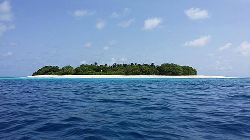


Dhigurah
- Area
- 0.55 km²
- High point
- 16 m
Feridhoo
- Area
- 0.46 km²
- High point
- 14 m
Mandhoo
- Area
- 0.39 km²
- High point
- 17 m
Maalhos
- Area
- 0.38 km²
- High point
- 18 m
Fenfushi
- Area
- 0.28 km²
- High point
- 13 m
Fenfushi (Dhivehi: ފެންފުށި) is one of the inhabited islands of Ari Atoll, belonging to the Alif Dhaal Atoll administrative division.
Ariadhoo
- Area
- 0.26 km²
- High point
- 19 m
Ariadhoo (Dhivehi: އަރިއަދޫ) is one of the uninhabited islands of Alif Dhaal Atoll near Maamigili island. The name ”Ari Atoll” is also thought to originate from Ariadhoo island.
Omadhoo
- Area
- 0.23 km²
- High point
- 11 m
Mahibadhoo
- Area
- 0.23 km²
- High point
- 7 m
Dhiddhoo
- Area
- 0.22 km²
- High point
- 19 m
Dhidhdhoo (Dhivehi: ދިއްދޫ) is one of the inhabited islands of Alif Dhaal Atoll.
Himandhoo
- Area
- 0.17 km²
- High point
- 12 m
Dhiddhoofinolhu
- Area
- 0.16 km²
- High point
- 13 m
Minor islands
Hukurudhoo
- Area
- 0.13 km²
- High point
- 18 m
Bodufolhudhoo
- Area
- 0.12 km²
- High point
- 13 m
Vilamendhoo
- Area
- 0.11 km²
- High point
- 13 m
Unnamed island
- Area
- —
size unknown
Unnamed island
- Area
- —
size unknown
Unnamed island
- Area
- —
size unknown
Bodufinolhu
- Area
- —
size unknown
Finolhu
- Area
- —
size unknown
Gasfinolhu
- Area
- —
size unknown
Medhufinolhu
- Area
- —
size unknown
Medhugiri
- Area
- —
size unknown
Rashukolhuhuraa
- Area
- —
size unknown
Villingili
- Area
- —
size unknown
Islets
- Velidhoo13 m · 0.1 km²
- Fenfushi4 m · 0.1 km²
- Rangalifinolhu11 m · 0.09 km²
- Veligandu12 m · 0.07 km²
- Moofushi10 m · 0.06 km²
- Villinglivaru9 m · 0.06 km²
- Madoogali14 m · 0.06 km²
- Huvahendhoo7 m · 0.06 km²
- Ellaidhoo10 m · 0.06 km²
- Rangali10 m · 0.05 km²
- Vakarufalhi12 m · 0.05 km²
- Halaveli6 m · 0.05 km²
Rocks & skerries
- Huruelhi6 m · 0.07 km²
- Unnamed island<0.1 ha
- Unnamed island<0.1 ha
- Unnamed island<0.1 ha
- Unnamed island<0.1 ha
Figures
Comparative heights
To the same scale
Islands by area
| Maamigili | 2.1 km² |
| Thoddoo | 1.6 km² |
| Dhigurah | 0.55 km² |
| Nalaguraidhoo | 0.54 km² |
| Feridhoo | 0.46 km² |
| Mandhoo | 0.39 km² |
| Maalhos | 0.38 km² |
| Kuramathi | 0.31 km² |
| Fenfushi | 0.28 km² |
| Dhangethi | 0.28 km² |
| Ariadhoo | 0.26 km² |
| Omadhoo | 0.23 km² |
| Ukulhas | 0.23 km² |
| Mahibadhoo | 0.23 km² |
| Mathiveri | 0.22 km² |
| Dhiddhoo | 0.22 km² |
| Rasdhoo | 0.21 km² |
| Hangnaameedhoo | 0.21 km² |
| Dhiffushi | 0.2 km² |
| Himandhoo | 0.17 km² |
| Dhiddhoofinolhu | 0.16 km² |
| Hukurudhoo | 0.13 km² |
| Bodufolhudhoo | 0.12 km² |
| Vilamendhoo | 0.11 km² |
| Velidhoo | 0.1 km² |
| Fenfushi | 0.1 km² |
| Rangalifinolhu | 0.09 km² |
| Veligandu | 0.07 km² |
| Huruelhi | 0.07 km² |
| Moofushi | 0.06 km² |
| Villinglivaru | 0.06 km² |
| Madoogali | 0.06 km² |
| Huvahendhoo | 0.06 km² |
| Ellaidhoo | 0.06 km² |
| Rangali | 0.05 km² |
| Vakarufalhi | 0.05 km² |
| Halaveli | 0.05 km² |
| Kandholhudhoo | 0.05 km² |
| Angaagaa | 0.05 km² |
| Fesdhoo | 0.04 km² |
| Machchafushi | 0.04 km² |
| Thudufushi | 0.04 km² |
| Hurasdhoo | 0.04 km² |
| Kudarah | 0.04 km² |
| Ranfinolhu | 0.04 km² |
| Mushimasgali | 0.04 km² |
| Innafushi | 0.03 km² |
| Maayafushi | 0.03 km² |
| Bathala | 0.03 km² |
| Athuruga | 0.03 km² |
| Unnamed island | 0.03 km² |
| Unnamed island | 0.03 km² |
| Gangehi | 0.03 km² |
| Maafushivaru | 0.03 km² |
| Bodukaashihuraa | 0.03 km² |
| Kandolhudhoo | 0.02 km² |
| Etheramadivaru | 0.02 km² |
| Bulhaaholhi | 0.02 km² |
| Mathivereefinolhu | 0.02 km² |
| Villinglivaru | 0.02 km² |
| Tholhifushi | 0.02 km² |
| Maagaa | 0.02 km² |
| Heenfaru | 0.02 km² |
| Mirihi | 0.02 km² |
| Alikoirah | 0.02 km² |
| Enboodhoo | 0.02 km² |
| Kalhuhandhihuraa | 0.01 km² |
| Theluveligaa | 0.01 km² |
| Gaathu Fushi | 0.01 km² |
| Dhinnolhu Finolhu | 0.01 km² |
| Unnamed island | 0.01 km² |
| Unnamed island | 1 ha |
| Ukulhas Fushi | 0.9 ha |
| Unnamed island | 0.9 ha |
| Rahddhiggaa | 0.9 ha |
| Dhehasanulunboihuraa | 0.8 ha |
| Madivaru Finolhu | 0.7 ha |
| Kudadhoo | 0.6 ha |
| Madivaru | 0.6 ha |
| Unnamed island | 0.6 ha |
| Beyrumadivaru | 0.5 ha |
| Unnamed island | 0.5 ha |
| Unnamed island | 0.4 ha |
| Unnamed island | 0.4 ha |
| Unnamed island | 0.4 ha |
| Unnamed island | 0.4 ha |
| Unnamed island | 0.4 ha |
| Unnamed island | 0.2 ha |
| Unnamed island | 0.2 ha |
| Hiyafushi | 0.2 ha |
| Unnamed island | 0.2 ha |
| Unnamed island | 0.2 ha |
| Unnamed island | 0.1 ha |
| Unnamed island | 0.1 ha |
| Unnamed island | 0.1 ha |
| Unnamed island | 0.1 ha |
| Unnamed island | <0.1 ha |
| Unnamed island | <0.1 ha |
| Unnamed island | <0.1 ha |
| Unnamed island | <0.1 ha |
Photographs
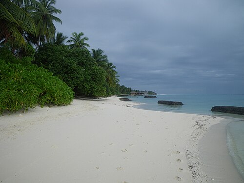
Kuramathi Strand (Lagunenseite)

Nalaguraidhoo (Sun Island) Northern Beach Lagoon View to the West towards Fenfushi Island

Maldives, Thoddoo

Bathalaa, Maldives


Dhigurah is the long island in the background, not the barrier in the foreground.

North Central Province, Maldives


Hangnaameedhoo aerial view

Dolphins

Badharu..
Sources
Facts
Photographs
- Kuramathi Beach (Lagoon) 001. MBraun Germany / Public domain
- Nalaguraidhoo Strand Lagune Nordseite Blick nach Westen. Dr. Peter Schmidt / CC BY-SA 3.0
- Maldives, Thoddoo - panoramio (39). Alx R / CC BY 3.0
- Atoll. (Unsplash). Syd Sujuaan sydsujuaan / CC0
- Ari Atoll, Maldives ESA22111096. European Space Agency / Attribution
- Dhigurah. Syced / CC BY-SA 3.0
- Lost (Unsplash IQx-XuRH3Rk). Ishan @seefromthesky seefromthesky / CC0
- 020 - Chasing Manta's (8536442920). Neville Wootton from Liskeard, UK / CC BY 2.0
- Hangnaameedhoo. Ximpepe / CC BY-SA 4.0
- Dolphins (15378898086). Laika ac from UK / CC BY-SA 2.0
- Ari WV banner. MissvainOriginal author: User:Civvi / CC BY-SA 3.0
- Badharu.. - panoramio. @.IMAD.COM / CC BY-SA 3.0