Netherlands
12°10′N 69°00′W
ABC islands
Part of Leeward Antilles and Leeward Islands
The ABC islands are the physical group of Aruba, Bonaire, and Curaçao, the three westernmost islands of the Leeward Antilles in the Caribbean Sea.

Chart
Overview
The ABC islands are the physical group of Aruba, Bonaire, and Curaçao, the three westernmost islands of the Leeward Antilles in the Caribbean Sea. These islands have a shared political history and a status of Dutch underlying ownership, since the Anglo-Dutch Treaty of 1814 ceded them back to the Kingdom of the Netherlands, as Curaçao and Dependencies from 1815. They are a short distance north of the Falcón State, Venezuela. Aruba and Curaçao are autonomous, self governing constituent countries of the Kingdom of the Netherlands, while Bonaire is a special municipality of the Netherlands. Territories of the Kingdom of the Netherlands, the countries, and its special municipalities, are outside the European Union; citizens have Dutch nationality and the former colonial power benefits from preferential trade, mineral and natural resource rights, particularly offshore.
From Wikipedia, CC BY-SA 4.0
Census, cataloged
- Major islands3
- Minor islands1
- Islets0
- Rocks & skerries19
Major islands

Curaçao
- Area
- 428 km²
- High point
- 372 m
Curaçao, officially the Country of Curaçao, is a constituent country within the Kingdom of the Netherlands. It is an island country located in the southern Caribbean Sea, specifically the Dutch Caribbean region, about 65 km (40 mi) north of Venezuela and 80 km (50 mi) southeast of Aruba.
Minor islands
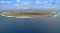
Klein Bonaire
- Area
- 6.9 km²
- High point
- 7 m
Rocks & skerries
- Unnamed island<0.1 ha
- Unnamed island<0.1 ha
- Unnamed island<0.1 ha
- Unnamed island<0.1 ha
- Unnamed island<0.1 ha
- Unnamed island<0.1 ha
- Unnamed island<0.1 ha
- Unnamed island<0.1 ha
- Unnamed island<0.1 ha
- Unnamed island<0.1 ha
- Unnamed island<0.1 ha
- Unnamed island<0.1 ha
Figures
Comparative heights
- Curaçao: 372 m
- Bonaire: 241 m
- Aruba: 188 m
- Klein Bonaire: 7 m
To the same scale
Islands by area
| Curaçao | 428 km² |
| Bonaire | 272 km² |
| Aruba | 179 km² |
| Klein Bonaire | 6.9 km² |
| Unnamed island | <0.1 ha |
| Unnamed island | <0.1 ha |
| Unnamed island | <0.1 ha |
| Unnamed island | <0.1 ha |
| Unnamed island | <0.1 ha |
| Unnamed island | <0.1 ha |
| Unnamed island | <0.1 ha |
| Unnamed island | <0.1 ha |
| Unnamed island | <0.1 ha |
| Unnamed island | <0.1 ha |
| Unnamed island | <0.1 ha |
| Unnamed island | <0.1 ha |
| Unnamed island | <0.1 ha |
| Unnamed island | <0.1 ha |
| Unnamed island | <0.1 ha |
| Unnamed island | <0.1 ha |
| Unnamed island | <0.1 ha |
| Unnamed island | <0.1 ha |
| Unnamed island | <0.1 ha |
Overlapping groups
Photographs

Caribbean Netherlands

Parish burial ground next to the Church of Holy Mary, Santa Cruz, Aruba
Sources
Facts
Photographs
- Caribbean Netherlands (Unsplash zYjGtMpT fk). Austin Neill arstyy / CC0
- Church of Holy Mary (Aruba) 5. Caribiana / CC BY-SA 4.0