Unga Island
Île Unga
55°16′N 160°46′W
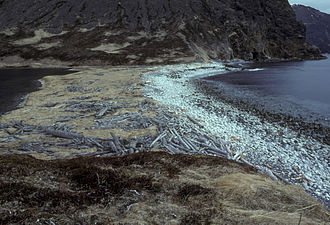
Unga Island (Uĝnaasaqax̂ in Aleut) is the largest of the Shumagin Islands off the Alaska Peninsula in southwestern Alaska, United States. The island has a land area of 170.73 sq mi (442.188 km2), making it the 36th largest island in the United States. As of the 2000 census, it had a permanent population of one.

Terrain
55°16′N 160°46′W
Overview
Unga Island (Uĝnaasaqax̂ in Aleut) is the largest of the Shumagin Islands off the Alaska Peninsula in southwestern Alaska, United States. The island has a land area of 170.73 sq mi (442.188 km2), making it the 36th largest island in the United States. As of the 2000 census, it had a permanent population of one. Unga Island was formerly named Grekodelarovskoe (Greek Delarov) for Greek explorer Evstratii Ivanovich Delarov Greek: (Ευστράτιος Ντελάρωφ) who explored the area in the late 18th century on behalf of the Russian-American Company. In 1968, Unga Island, was designated as a National Natural Landmark by the National Park Service.
From Wikipedia, CC BY-SA 4.0
Chart
Nearest islands
- Popof Island26 km
- Korovin Island34 km
- Nagai Island52 km
- Big Koniuji Island78 km
- Bird Island81 km
- Little Koniuji Island93 km
Also in Shumagin Islands
Nagai Island
293 km²▲ 514 m
Major islands

Popof Island
92.2 km²▲ 459 m
Major islands
Big Koniuji Island
89.8 km²▲ 555 m
Major islands
Korovin Island
66.7 km²▲ 552 m
Major islands
Little Koniuji Island
58.2 km²▲ 481 m
Minor islands

Simeonof Island
43.3 km²▲ 427 m
Minor islands
Chernabura Island
30.7 km²▲ 481 m
Minor islands
Bird Island
17.4 km²▲ 406 m
Minor islands
Sources
Facts
Photographs
- Masque funéraire Unangax-Château-musée de Boulogne-sur-Mer (3). Ji-Elle / CC BY-SA 4.0