Popof Island
Île Popof
55°18′N 160°21′W
Popof Island (Siitikdax̂ in Aleut) is an island in the Shumagin Islands south of mainland Alaska. The largest community in the area, Sand Point, is located on the northwest coast. 0 km) wide and the peak elevation is 1,550 feet (470 meters). It is located at 55°18′49″N 160°22′29″W.

Terrain
55°18′N 160°21′W
Overview
Popof Island (Siitikdax̂ in Aleut) is an island in the Shumagin Islands south of mainland Alaska. The largest community in the area, Sand Point, is located on the northwest coast. Popof Island is 10 miles (16 km) long, 5 miles (8.0 km) wide and the peak elevation is 1,550 feet (470 meters). It is located at 55°18′49″N 160°22′29″W. It has a land area of 93.651 km2 (36.159 sq mi) and a total population of 578 persons at the 2020 census.
Pirate Cove on the island was developed as a major codfish fishing station. A herd of introduced bison is on the uninhabited side of the island and currently numbers about 120.
From Wikipedia, CC BY-SA 4.0
Chart
Nearest islands
- Korovin Island14 km
- Unga Island26 km
- Nagai Island32 km
- Big Koniuji Island55 km
- Bird Island65 km
- Little Koniuji Island71 km
Also in Shumagin Islands

Unga Island
444 km²▲ 497 m
Major islands
Nagai Island
293 km²▲ 514 m
Major islands
Big Koniuji Island
89.8 km²▲ 555 m
Major islands
Korovin Island
66.7 km²▲ 552 m
Major islands
Little Koniuji Island
58.2 km²▲ 481 m
Minor islands

Simeonof Island
43.3 km²▲ 427 m
Minor islands
Chernabura Island
30.7 km²▲ 481 m
Minor islands
Bird Island
17.4 km²▲ 406 m
Minor islands
Photographs

Dawn on Unga Island in the distance

Dawn on Unga Island in the distance
Sources
Facts
Photographs
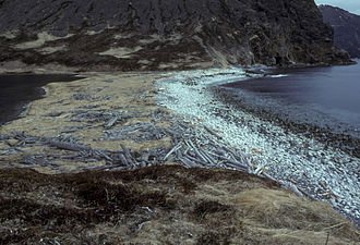
- Popof Island, Alaska (2803700201). Joseph from Cabin On The Road, USA / CC BY-SA 2.0
- Popof Island, Alaska (2803700207). Joseph from Cabin On The Road, USA / CC BY-SA 2.0