Saturna Island
Île Saturna
48°47′N 123°09′W
Saturna Island is a mountainous island, about 31 square kilometres (12 sq mi) in size, in the Southern Gulf Islands chain of British Columbia, Canada. C. and Vancouver Island, and is the most easterly of the Gulf Islands. It is surrounded on three sides by the Canada–United States border.

Terrain
48°47′N 123°09′W
Overview
Saturna Island is a mountainous island, about 31 square kilometres (12 sq mi) in size, in the Southern Gulf Islands chain of British Columbia, Canada. It is situated approximately midway between the Lower Mainland of B.C. and Vancouver Island, and is the most easterly of the Gulf Islands. It is surrounded on three sides by the Canada–United States border. To the north is Point Roberts, Washington, and to the east and south are the San Juan Islands. There is a First Nations reserve on the island for the Tsayout and Tseycum Nations. The island has a permanent population of around 350; however, this number increases during the summer season. Approximately half of the island is in the Gulf Islands National Park Reserve (GINPR) that was formed in 2003 from a gift of ecologically sensitive land by Ulla Ressner and John Fry, existing provincial parks, an Ecological Reserve, and other Crown land.
From Wikipedia, CC BY-SA 4.0
Chart
Nearest islands
- South Pender Island5.6 km
- Tumbo Island6.6 km
- Samuel Island6.8 km
- Pender Island9.3 km
- North Pender Island9.7 km
- Mayne Island11 km
Also in Gulf Islands

Texada Island
302 km²▲ 855 m
Major islands

Saltspring Island
185 km²▲ 709 m
Major islands

Lasqueti Island
66.5 km²▲ 328 m
Major islands

Galiano Island
58.1 km²▲ 300 m
Major islands

Gabriola Island
52.6 km²▲ 182 m
Major islands

Denman Island
51.6 km²▲ 124 m
Major islands
Pender Island
34 km²
Major islands

Hornby Island
30 km²▲ 305 m
Minor islands
Also in Lion Islets
Galiano Island
58.1 km²▲ 300 m
Minor islands
North Pender Island
27.1 km²▲ 218 m
Minor islands

Mayne Island
23.5 km²▲ 260 m
Minor islands
South Pender Island
9.1 km²▲ 266 m
Minor islands
Prevost Island
6.7 km²▲ 110 m
Minor islands
Samuel Island
2 km²▲ 130 m
Minor islands
Parker Island
1.7 km²▲ 129 m
Minor islands
Tumbo Island
1.2 km²▲ 70 m
Minor islands
Also in Chain Islands
Saltspring Island
185 km²▲ 709 m
Minor islands
Galiano Island
58.1 km²▲ 300 m
Minor islands
North Pender Island
27.1 km²▲ 218 m
Minor islands
Mayne Island
23.5 km²▲ 260 m
Minor islands
South Pender Island
9.1 km²▲ 266 m
Minor islands
Prevost Island
6.7 km²▲ 110 m
Minor islands
Samuel Island
2 km²▲ 130 m
Minor islands
Parker Island
1.7 km²▲ 129 m
Minor islands
Also in Deadman Islands
Saltspring Island
185 km²▲ 709 m
Minor islands
Galiano Island
58.1 km²▲ 300 m
Minor islands
North Pender Island
27.1 km²▲ 218 m
Minor islands
Mayne Island
23.5 km²▲ 260 m
Minor islands
South Pender Island
9.1 km²▲ 266 m
Minor islands
Prevost Island
6.7 km²▲ 110 m
Minor islands
Samuel Island
2 km²▲ 130 m
Minor islands
Parker Island
1.7 km²▲ 129 m
Minor islands
Photographs
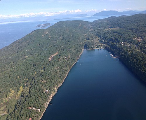
South-facing aerial view of Saturna Island

Great place to chase a wheel of cheese!

View of Saturna Island from the top of Mount Parke Regional Park

East Point Park


Brook Point Park from Mt. Warburton Pike


the strong tidal flow through Boat Pass between Samuel Island and Saturna Island, British Columbia, Canada

Boot Cove, Saturna Island, British Columbia, Canada

the campsite on Narvaez Bay in Gulf Islands National Park Reserve, Saturna Island, British Columbia, Canada

rock formations at East Point on Saturna Island, British Columbia, Canada

the Fog Alarm Building at East Point, Saturna Island, British Columbia, Canada, with the 1888 lighthouse in the background.
Sources
Facts
Photographs
- Saturna Island. Canuckle / CC0
- Great place to chase a wheel of cheese - panoramio. Kiwibirdman / CC BY 3.0
- View from Mount Parke Regional Park. MarcStevenBC / CC0
- East Point Park - panoramio. Kiwibirdman / CC BY 3.0
- Saturna Island 1. Tim / CC BY-SA 2.0
- Brook Point Park from Mt. Warburton Pike - panoramio. Kiwibirdman / CC BY 3.0
- Active Passage, Saturna Group, Looking West WDL2718. Alden, James Madison (1834-1922) / Public domain
- Boat Pass (7604531626). David Stanley from Nanaimo, Canada / CC BY 2.0
- Boot Cove (7604534462). David Stanley from Nanaimo, Canada / CC BY 2.0
- Campsite (7604530438). David Stanley from Nanaimo, Canada / CC BY 2.0
- East Point (7604532758). David Stanley from Nanaimo, Canada / CC BY 2.0
- Fog Alarm Building (7604533012). David Stanley from Nanaimo, Canada / CC BY 2.0