Rosario StraitCanada
48°57′N 123°32′W
Gulf Islands
The Gulf Islands is a group of islands in the Salish Sea between Vancouver Island and the mainland coast of British Columbia.

Chart
Overview
The Gulf Islands is a group of islands in the Salish Sea between Vancouver Island and the mainland coast of British Columbia.
From Wikipedia, CC BY-SA 4.0
Census, cataloged
- Major islands8
- Minor islands41
- Islets299
- Rocks & skerries144
Major islands
Texada Island
- Area
- 302 km²
- High point
- 855 m
Texada Island is a large island located in the Strait of Georgia of British Columbia, Canada. 00 mi2), it is the largest island of the Gulf Islands and the third largest island in the Strait of Georgia after Whidbey Island in Washington and Quadra Island of the Discovery Islands.
Saltspring Island
- Area
- 185 km²
- High point
- 709 m
Salt Spring Island or Saltspring Island is one of the Gulf Islands in the Strait of Georgia between mainland British Columbia, Canada, and Vancouver Island.
Lasqueti Island
- Area
- 66.5 km²
- High point
- 328 m
Lasqueti Island (US: lə-SKEE-tee) is an island off the east coast of Vancouver Island in the Strait of Georgia within qathet Regional District in British Columbia, Canada. As of 2021, it has a population of 498. A passenger-only ferry connects the island to the community of French Creek, near Parksville.
Galiano Island
- Area
- 58.1 km²
- High point
- 300 m
Galiano Island (Halkomelem: Swiikw) is one of the Southern Gulf Islands located between Vancouver Island and the Lower Mainland of British Columbia, Canada.
Gabriola Island
- Area
- 52.6 km²
- High point
- 182 m
Gabriola Island is one of the Gulf Islands in the Strait of Georgia in British Columbia (BC), Canada. 1 mi) east of Nanaimo on Vancouver Island, to which it is linked by a 20-minute ferry service. 2 sq mi) and a resident population of 4,500.
Denman Island
- Area
- 51.6 km²
- High point
- 124 m
Denman Island, (also known as lháytayich in the Comox language, meaning "Inner Island"), is one of the Northern Gulf Islands and part of the Comox Valley Regional District of British Columbia, Canada. It is a member of the Islands Trust group of islands and is home to a small community of 1,391 year-round residents.
Saturna Island
- Area
- 32.2 km²
- High point
- 402 m
Saturna Island is a mountainous island, about 31 square kilometres (12 sq mi) in size, in the Southern Gulf Islands chain of British Columbia, Canada. C. and Vancouver Island, and is the most easterly of the Gulf Islands. It is surrounded on three sides by the Canada–United States border.


Pender Island
- Area
- 34 km²
Pender Island (Saanich: st̕ey̕əs) is the collective name for two Southern Gulf Islands located in the Salish Sea, British Columbia, Canada. The Pender Islands, consisting of North Pender Island and South Pender Island, have a combined area of approximately 34 km2 (13 sq mi).
Minor islands

Hornby Island
- Area
- 30 km²
- High point
- 305 m
North Pender Island
- Area
- 27.1 km²
- High point
- 218 m

Valdes Island
- Area
- 24.5 km²
- High point
- 209 m

Mayne Island
- Area
- 23.5 km²
- High point
- 260 m

Thetis Island
- Area
- 11.3 km²
- High point
- 151 m

Penelakut Island
- Area
- 9.5 km²
- High point
- 91 m
South Pender Island
- Area
- 9.1 km²
- High point
- 266 m
South Thormanby Island
- Area
- 6.9 km²
- High point
- 156 m
Prevost Island
- Area
- 6.7 km²
- High point
- 110 m

Savary Island
- Area
- 4.9 km²
- High point
- 79 m
Jedediah Island
- Area
- 2.7 km²
- High point
- 140 m

Mudge Island
- Area
- 2.2 km²
- High point
- 89 m
Samuel Island
- Area
- 2 km²
- High point
- 130 m
De Courcy Island
- Area
- 2 km²
- High point
- 64 m
Parker Island
- Area
- 1.7 km²
- High point
- 129 m
North Thormanby Island
- Area
- 1.6 km²
- High point
- 86 m
Reid Island
- Area
- 0.97 km²
- High point
- 56 m
Ruxton Island
- Area
- 0.97 km²
- High point
- 90 m
Jervis Island
- Area
- 0.96 km²
- High point
- 101 m
Wallace Island
- Area
- 0.87 km²
- High point
- 51 m
Jenkins Island
- Area
- 0.75 km²
- High point
- 68 m
Bull Island
- Area
- 0.72 km²
- High point
- 107 m
Protection Island
- Area
- 0.67 km²
- High point
- 18 m
Secretary Islands
- Area
- 0.6 km²
- High point
- 77 m
Pylades Island
- Area
- 0.57 km²
- High point
- 82 m
Turnagain Island
- Area
- 0.38 km²
- High point
- 66 m
Gossip Island
- Area
- 0.35 km²
- High point
- 39 m
Curlew Island
- Area
- 0.3 km²
- High point
- 61 m
Unnamed island
- Area
- 0.29 km²
- High point
- 49 m
Link Island
- Area
- 0.27 km²
- High point
- 48 m
Tent Island
- Area
- 0.26 km²
- High point
- 48 m
Hall Island
- Area
- 0.22 km²
- High point
- 46 m
Paul Island
- Area
- 0.2 km²
- High point
- 61 m
Rabbit Island
- Area
- 0.16 km²
- High point
- 43 m
Boho Island
- Area
- 0.15 km²
- High point
- 52 m
Hudson Island
- Area
- 0.15 km²
- High point
- 35 m
Dayman Island
- Area
- 0.14 km²
- High point
- 36 m
Norway Island
- Area
- 0.14 km²
- High point
- 43 m
Finnerty Islands
- Area
- 0.13 km²
- High point
- 38 m
Wise Island
- Area
- 0.13 km²
- High point
- 35 m
Higgins Island
- Area
- 0.12 km²
- High point
- 48 m
Rocks & skerries
On the chart above, at its closest zooms.
Listing 49 of 492; the rest are on the chart.
Figures
Comparative heights
- Texada: 855 m
- Saltspring: 709 m
- Saturna: 402 m
- Lasqueti: 328 m
- Hornby: 305 m
- Galiano: 300 m
- South Pender: 266 m
- Mayne: 260 m
- North Pender: 218 m
- Valdes: 209 m
- Gabriola: 182 m
- South Thormanby: 156 m
- Thetis: 151 m
- Jedediah: 140 m
To the same scale
Islands by area
Groups within
Overlapping groups
Photographs

Texada

View from Baynes Peak, Saltspring Island, British Columbia, Canada
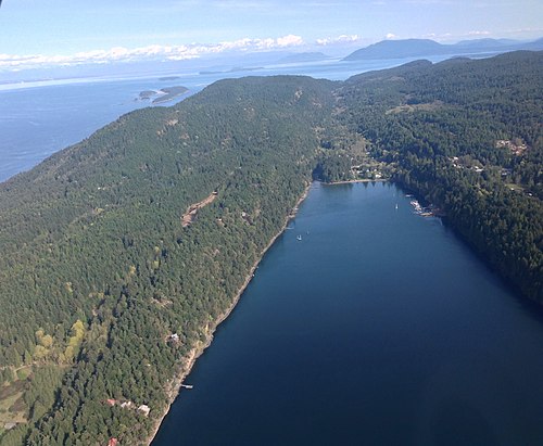
South-facing aerial view of Saturna Island

Taken by user:Clayoquot in 2006
No machine-readable author provided. Clayoquot assumed (based on copyright claims). / CC BY-SA 3.0

Descanso Bay on Gabriola Island, British Columbia. Taken by user:Clayoquot
No machine-readable author provided. Clayoquot assumed (based on copyright claims). / CC BY-SA 3.0

IMG_2272.jpg

Bodega Ridge Provincial Park

Coming over the Gulf Islands

The Gulf Islands

Spartina Densiflora Denman Isl 1


Lasqueti Island Fire Hall
Sources
Facts
Photographs
- Paul Hamilton - Texada 1. Paul Hamilton / CC BY-SA 2.0
- View from Baynes Peak, Saltspring Island, British Columbia, Canada 04. Michal Klajban / CC BY-SA 4.0
- Saturna Island. Canuckle / CC0
- From Mount Galiano. No machine-readable author provided. Clayoquot assumed (based on copyright claims). / CC BY-SA 3.0
- Taylor Bay Gabriola. No machine-readable author provided. Clayoquot assumed (based on copyright claims). / CC BY-SA 3.0
- British Columbia IMG 2272 (14418959980). Maciej / CC BY-SA 2.0
- Bodega Ridge Provincial Park - panoramio. AB87 / CC BY 3.0
- Coming over the Gulf Islands (375233186). Shawn from Airdrie, Canada / CC BY-SA 2.0
- The Gulf Islands (490783285). Shawn from Airdrie, Canada / CC BY-SA 2.0
- Spartina Densiflora Denman Isl 1. VIUDeepBay from Nanaimo, Canada / CC BY 2.0
- Dodd Narrows from Mudge Island (4651542399). gordon hunter from Nanaimo, BC, Canada / CC BY-SA 2.0
- Lasqueti Island Fire Hall - panoramio. Kiwibirdman / CC BY 3.0