Mellum
53°43′N 8°09′E
Mellum (German pronunciation: [ˈmɛlʊm] ) is an uninhabited island lying southeast of Wangerooge, off the coastal settlements of Horumersiel and Schillig in Germany.

Terrain
53°43′N 8°09′E
Overview
Mellum (German pronunciation: [ˈmɛlʊm] ) is an uninhabited island lying southeast of Wangerooge, off the coastal settlements of Horumersiel and Schillig in Germany. Mellum formed as an island off the end of the Butjadingen peninsula—which divides the outflows into the Wadden Sea of the Jade and Weser rivers—only at the end of the nineteenth century. It is chiefly composed of dunes and tidal marshes. The influence of sea currents and winds is constantly altering the shape and position of the island, which in 2006 had a total surface area of approximately 750 hectares (1853 acres). An important breeding and feeding ground for wild birds, Mellum is part of the Lower Saxony Wadden Sea National Park and a nature protection zone. The island's only house is today used during the summer months for wildlife observation and scientific research purposes only.
From Wikipedia, CC BY-SA 4.0
Chart
Nearest islands
- Minsener Oog11 km
- Wangerooge20 km
- Spiekeroog27 km
- Langeoog44 km
- Baltrum49 km
- Norderney63 km
Also in East Frisian Islands

Borkum
34.7 km²▲ 24 m
Major islands

Norderney
27.9 km²▲ 20 m
Major islands

Langeoog
19.8 km²▲ 20 m
Major islands

Spiekeroog
18.1 km²▲ 24 m
Major islands

Juist
14.7 km²▲ 23 m
Major islands

Wangerooge
8.6 km²▲ 17 m
Major islands

Baltrum
6.6 km²▲ 19 m
Minor islands

Minsener Oog
4.2 km²▲ 12 m
Minor islands
Also in Frisian Islands

Texel
159 km²▲ 24 m
Major islands
Rømø
129 km²▲ 3 m
Major islands

Terschelling
85.2 km²▲ 31 m
Major islands

Föhr
82.8 km²▲ 11 m
Major islands

Fanø
60.7 km²▲ 21 m
Major islands

Ameland
57.4 km²▲ 24 m
Major islands
Sylt
57.3 km²▲ 53 m
Major islands

Schiermonnikoog
43.7 km²▲ 20 m
Major islands
Photographs

Aerial image of Mellum (view from the southeast)

Apfelbaum auf Mellum

Flakdenkmal Mellum

Mellum Feuerlöschteich

Mellum mit Offshore-Windpark

Mellum Ringdeich von außen

Mellum Schild

Ringdeich Mellum Innenseite

Vegetation auf Mellum

Verbrannte Vegetation auf Mellum
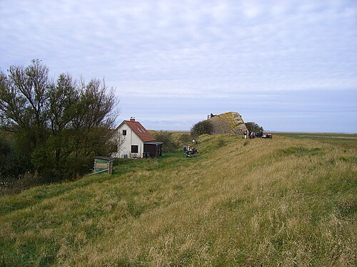
Mellum -Haus des Vogelwartes

Offshore-Windpark Nordergründe von der Insel Mellum fotografiert.
Sources
Facts
Photographs
- Aerial image of Mellum (view from the southeast). Carsten Steger / CC BY-SA 4.0
- Apfelbaum auf Mellum. Schamarn / CC BY-SA 4.0
- Flakdenkmal Mellum. Schamarn / CC BY-SA 4.0
- Mellum Feuerlöschteich. Schamarn / CC BY-SA 4.0
- Mellum mit Offshore-Windpark. Schamarn / CC BY-SA 4.0
- Mellum Ringdeich von außen. Schamarn / CC BY-SA 4.0
- Mellum Schild. Schamarn / CC BY-SA 4.0
- Ringdeich Mellum Innenseite. Schamarn / CC BY-SA 4.0
- Vegetation auf Mellum. Schamarn / CC BY-SA 4.0
- Verbrannte Vegetation auf Mellum. Schamarn / CC BY-SA 4.0
- Mellum (Pic Surface 53 - Blick Richtung W v. E d. Eingedeichten). pixelfehler / CC BY-SA 2.5
- Offshore-Windpark Nordergründe von Mellum. Schamarn / CC BY-SA 4.0