Philippines
6°00′N 121°00′E
Sulu Archipelago
Part of Mindanao
The Sulu Archipelago (Tausug: Kapū'-pūan sin Sūg; Sulat Sūg: كَفُوْءْفُوْأَنْ سِنْ سُوْݢْ; Filipino: Kapuluan ng Sulu) is a chain of islands in the Pacific Ocean in the southwestern Philippines. The archipelago forms the northern limit of the Celebes Sea and southern limit of the Sulu Sea.

Chart
Overview
The Sulu Archipelago (Tausug: Kapū'-pūan sin Sūg; Sulat Sūg: كَفُوْءْفُوْأَنْ سِنْ سُوْݢْ; Filipino: Kapuluan ng Sulu) is a chain of islands in the Pacific Ocean in the southwestern Philippines. The archipelago forms the northern limit of the Celebes Sea and southern limit of the Sulu Sea. The Sulu Archipelago islands are within the Mindanao island group, consisting of the Philippines provinces of Basilan, Sulu, and Tawi-Tawi; hence, the archipelago is sometimes referred to as Basulta, derived from the first syllables of the three provinces. The archipelago is not, as is often supposed, the remains of a land bridge between Borneo and the Philippines. Rather, it is the exposed edge of small submarine ridges produced by tectonic tilting of the sea bottom. Basilan, Jolo, Tawi-Tawi and other islands in the group are extinct volcanic cones rising from the southernmost ridge. Tawi-Tawi, the southernmost island of the group, has a serpentine basement-complex core with a limestone covering. This island chain is an important migration route for birds. The largest municipalities in the area are on the island of Jolo. The larger island of Palawan to its north, the coastal regions of the westward-extending Zamboanga Peninsula of Mindanao, and the north-eastern part of the island of Borneo were formerly parts of the thalassocratic Sultanate of Sulu. The archipelago is the home of the indigenous Tausūg people and various groups of Sama(l) peoples, including the semi-nomadic Bajau; the land-based Sama; the related Yakan people; and the Jama Mapun people. The Tausug language is widely spoken in the Sulu Archipelago as both a first and a second language across these islands. Sama-Bajaw languages are also spoken. The Yakan language is spoken mainly in Basilan Island. Numerous dialects of Sinama are spoken throughout the archipelago, from the Tawi-Tawi Island group, to the Mapun island group, to the coast of Mindanao and beyond.
From Wikipedia, CC BY-SA 4.0
Census, cataloged
- Major islands3
- Minor islands62
- Islets206
- Rocks & skerries31
Major islands
Basilan Island
- Area
- 1,218 km²
- High point
- 990 m
Basilan, officially the Province of Basilan, is an island province of the Philippines located primarily in the Bangsamoro Autonomous Region. Basilan Island is the largest and northernmost of the major islands of the Sulu Archipelago. It is just off the southern coast of the geographic Zamboanga Peninsula.
Tawi-Tawi Island
- Area
- 565 km²
- High point
- 535 m
Tawitawi Island (also spelled Tawi Tawi or Tawi-Tawi) is a Philippine island in the Sulu Archipelago between the Sulu Sea and Celebes Sea, about 64 kilometres (40 mi; 35 nmi) east of Borneo. It is the main island of Tawi-Tawi Province, with a little more than half the province's 1,087.40 km2 (419.85 sq mi) land area.


Jolo
- Area
- 807 km²
- High point
- 790 m
Jolo (Tausug: Sūg) is a volcanic island in the southwest Philippines and the primary island of the province of Sulu, on which the capital of the same name is situated. It is located in the Sulu Archipelago, between Borneo and Mindanao, and has a population of approximately 500,000 people.
Minor islands

Sibutu Island
- Area
- 104 km²
- High point
- 137 m
Sanga-Sanga Island
- Area
- 40.9 km²
- High point
- 97 m
Tandubatu Island
- Area
- 30.8 km²
- High point
- 143 m
Lintian Island
- Area
- 30.1 km²
- High point
- 198 m
Tumindao Island
- Area
- 18.9 km²
- High point
- 19 m
Bongao Island
- Area
- 10.2 km²
- High point
- 342 m

Tumbagaan Island
- Area
- 7.5 km²
- High point
- 190 m
Tigungun Island
- Area
- 7 km²
- High point
- 111 m
Diar-Diar
- Area
- 6.1 km²
- High point
- 68 m

Basbas Island
- Area
- 5.3 km²
- High point
- 65 m
Naunghn Island
- Area
- 4.6 km²
- High point
- 148 m
Tabulunga Island
- Area
- 4.2 km²
- High point
- 24 m
Omapuy Island
- Area
- 4 km²
- High point
- 19 m
Taruk Island
- Area
- 3.3 km²
- High point
- 70 m
Patian Island
- Area
- 2.5 km²
- High point
- 123 m

Pababag Island
- Area
- 2.2 km²
- High point
- 26 m
Tulayan Island
- Area
- 1.5 km²
- High point
- 161 m
Kalupag Island
- Area
- 1.3 km²
- High point
- 81 m
Lupa Island
- Area
- 1.3 km²
- High point
- 24 m
Buan Island
- Area
- 1.1 km²
- High point
- 95 m
Pamisaan Island
- Area
- 1.1 km²
- High point
- 7 m
Sipangkot Island
- Area
- 1 km²
- High point
- 18 m
Gujangan Island
- Area
- 1 km²
- High point
- 122 m
Parangan Island
- Area
- 0.95 km²
- High point
- 55 m
Buli Nusa Island
- Area
- 0.86 km²
- High point
- 11 m
Gusi Island
- Area
- 0.71 km²
- High point
- 11 m
Tamloylangan Island
- Area
- 0.68 km²
- High point
- 96 m
Nanacaan Island
- Area
- 0.68 km²
- High point
- 26 m
Pintada Island
- Area
- 0.65 km²
- High point
- 84 m
Bakhan Dakula Island
- Area
- 0.58 km²
- High point
- 20 m
Bakungan Island
- Area
- 0.55 km²
- High point
- 136 m
Tunbauhan
- Area
- 0.5 km²
- High point
- 7 m
Unnamed island
- Area
- 0.49 km²
- High point
- 10 m
Cabankauan Island
- Area
- 0.48 km²
- High point
- 7 m
Mayemayo Island
- Area
- 0.42 km²
- High point
- 47 m
Lumbian Island
- Area
- 0.35 km²
- High point
- 33 m
Pasinguan Island
- Area
- 0.33 km²
- High point
- 43 m
Daluman Island
- Area
- 0.31 km²
- High point
- 6 m
Nungan Dakula Island
- Area
- 0.3 km²
- High point
- 58 m
Bauang Diki Island
- Area
- 0.3 km²
- High point
- 120 m
Barun Sibi Sibi
- Area
- 0.27 km²
- High point
- 8 m
Tauntong Diki Island
- Area
- 0.25 km²
- High point
- 5 m
Taata Island
- Area
- 0.25 km²
- High point
- 14 m
Taletao Island
- Area
- 0.21 km²
- High point
- 17 m
Tausan Bongo Island
- Area
- 0.2 km²
- High point
- 2 m
Saluag Island
- Area
- 0.2 km²
- High point
- 12 m
Lebbukan Island
- Area
- 0.19 km²
- High point
- 16 m
Cava Island
- Area
- 0.19 km²
- High point
- 99 m
Unnamed island
- Area
- 0.19 km²
- High point
- 5 m
Saruk Sarokkan Island
- Area
- 0.17 km²
- High point
- 57 m
Unnamed island
- Area
- 0.16 km²
- High point
- 12 m
Suka Suka Dacula Island
- Area
- 0.16 km²
- High point
- 8 m
Unnamed island
- Area
- 0.16 km²
- High point
- 44 m
Tauntong-tauntong Island
- Area
- 0.15 km²
- High point
- 5 m
Nusa Buani Island
- Area
- 0.12 km²
- High point
- 12 m

Mardanas Island
- Area
- 0.12 km²
- High point
- 3 m
Sicolan Island
- Area
- 0.11 km²
- High point
- 16 m

Panampangan Island
- Area
- 0.1 km²
- High point
- 7 m
Tonkain Islands
- Area
- 0.1 km²
- High point
- 5 m
Unnamed island
- Area
- 0.1 km²
- High point
- 14 m
Sicolan Caloh Island
- Area
- —
size unknown
Sugbai
- Area
- —
size unknown
Rocks & skerries
On the chart above, at its closest zooms.
Listing 65 of 302; the rest are on the chart.
Figures
Comparative heights
To the same scale
Islands by area
Groups within
Photographs

万国来朝图 Sulu Archipelago (苏禄国) delegates in Peking in 1761
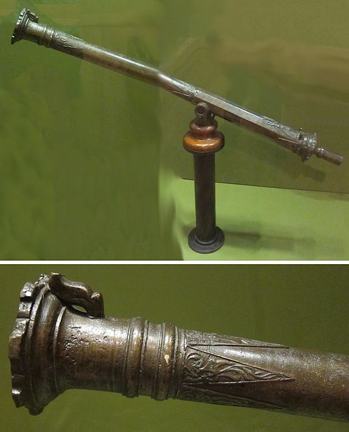
Moro cannon or swivel gun (lantaka) from the Sulu Archipelago, brass, Honolulu Museum of Art

Sword from the Sulu Archipelago, Philippines, metal, wood, Honolulu Museum of Art accession 12570.1

Sword from the Sulu Archipelago, Philippines, metal, wood, Honolulu Museum of Art accession 12571.1

1879 photo of Sultan Jamalul Azam of Sulu.

Tube shirt (patadyong) from the Philippines, Sulu Archipelago, 20th century, silk, tapestry weave, Honolulu Museum of Art accession 5882.1

Sash from the Sulu Archipelago, Tausug, 20th century, silk, tapestry weave, Honolulu Museum of Art accession 5881.1
Sources
Facts
Photographs
- 万国来朝图 Sulu Archipelago (苏禄国) delegates in Peking in 1761. China, 1761 painter / Public domain
- WV banner Sulu Archipelago Tawi Tawi panorama. U.S. Navy photo by Chief Photographer's Mate Edward G. Martens / Public domain
- Moro cannon or swivel gun (lantaka) from the Sulu Archipelago, brass, Honolulu Museum of Art. Hiart / CC0
- Sword from the Sulu Archipelago, Philippines, Honolulu Museum of Art. Hiart / CC0
- Sword from the Sulu Archipelago, Philippines, Honolulu Museum of Art II. Hiart / CC0
- Sultan Jamalul Azam (1879 photo) - original. H. Thiriat / Public domain
- Tube shirt (patadyong) from the Philippines, Sulu Archipelago, Honolulu Museum of Art . AnonymousUnknown author / Public domain
- Sash from the Sulu Archipelago, Honolulu Museum of Art 5881.1. Hiart / CC0