Atlantic OceanIreland
51°46′N 10°32′W
Skellig Islands
The Skellig Islands (Irish: Na Scealaga), historically "the Skellocks", are two small, steep, and rocky islands lying about 13 km (8 mi) west of Bolus Head off the Iveragh Peninsula in County Kerry, Ireland.

Chart
Overview
The Skellig Islands (Irish: Na Scealaga), historically "the Skellocks", are two small, steep, and rocky islands lying about 13 km (8 mi) west of Bolus Head off the Iveragh Peninsula in County Kerry, Ireland. The larger of the two is Skellig Michael (also known as Great Skellig), famous for an early Christian monastery that is a UNESCO World Heritage Site. Together with Little Skellig, they make up a 364-hectare (899-acre) Important Bird Area.
From Wikipedia, CC BY-SA 4.0
Census, cataloged
- Major islands2
- Minor islands0
- Islets0
- Rocks & skerries0
Major islands
Skellig Michael
- Area
- 0.22 km²
- High point
- 218 m
2 mi) west of the Iveragh Peninsula in County Kerry, Ireland. The island is named after the archangel Michael; while "Skellig" is derived from the Irish language word sceilig, meaning a splinter of stone. Its twin island, Little Skellig (Sceilig Bheag), is smaller and inaccessible. The two islands were formed c.
Little Skellig
- Area
- 0.12 km²
- High point
- 134 m
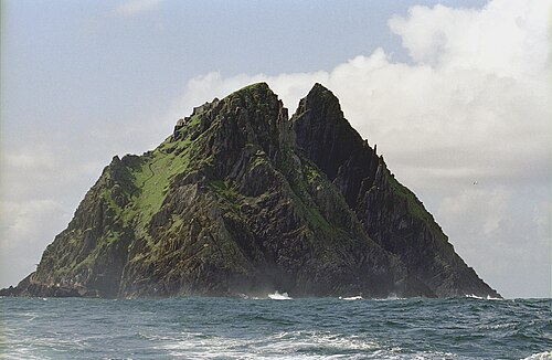
Little Skellig (Irish: Sceilig Bheag) is a small, steep rocky island in the Atlantic Ocean, 11 km off the Iveragh Peninsula of County Kerry, Ireland. It is one of the two Skellig Islands, together with the larger Skellig Michael. Little Skellig is a nature reserve and bird colony.

Figures
Comparative heights
- Skellig Michael: 218 m
- Little Skellig: 134 m
To the same scale
Islands by area
Overlapping groups
Photographs
The Skellig Michael

A view of Skellig Islands

Skellig Micheal, an island 12 km west of County Kerry in Ireland

The Little Skellig

A view of Skellig Islands off the southwest coast of Ireland

A view off the Skellig Islands from the sea

En route to Kerry

Summer solstice sunset between the Skelligs

Portmagee + Skellig Ring + Ring of Kerry
Tony Webster from Portland, Oregon, United States / CC BY 2.0

Ring of Kerry Kerry’s Most Spectacular Cliffs and the Skellig Islands 12283084746 o

Through the Arch

The Skellig Rocks as seen from Valentia Island
Sources
Facts
Photographs
- Skellig Michael03(js). Jerzy Strzelecki / CC BY-SA 3.0
- Moher13(js). Jerzy Strzelecki / CC BY-SA 3.0
- Skellig Michael. User:Gdr. / CC BY-SA 3.0
- LittleSkellig01(js). Jerzy Strzelecki / CC BY-SA 3.0
- Moher12(js). Jerzy Strzelecki / CC BY-SA 3.0
- SkelligIslands01(js). Jerzy Strzelecki / CC BY-SA 3.0
- Skelligs 1 (13961369069). Irish Defence Forces from Ireland / CC BY 2.0
- Summer solstice sunset between the Skelligs - geograph.org.uk - 1928856. Keith Cunneen / CC BY-SA 2.0
- Portmagee + Skellig Ring + Ring of Kerry (11003378326). Tony Webster from Portland, Oregon, United States / CC BY 2.0
- Ring of Kerry Kerry’s Most Spectacular Cliffs and the Skellig Islands 12283084746 o. Tony Webster / CC BY-SA 3.0
- Through the Arch - geograph.org.uk - 2447523. Adam Ward / CC BY-SA 2.0
- SkelligIslands. Pklauss / CC BY-SA 3.0