North SeaUnited Kingdom
60°21′N 1°16′W
Shetland
Shetland Islands
Part of British Isles
Shetland, also called the Shetland Islands, is an archipelago in Scotland lying between Orkney, the Faroe Islands, and Norway, marking the northernmost region of the United Kingdom.

Chart
Overview
Shetland, also called the Shetland Islands, is an archipelago in Scotland lying between Orkney, the Faroe Islands, and Norway, marking the northernmost region of the United Kingdom. The islands lie about 50 miles (80 kilometres) to the northeast of Orkney, 110 mi (170 km) from mainland Scotland, and 140 mi (220 km) west of Norway. They form part of the border between the Atlantic Ocean to the west and the North Sea to the east. The islands' area is 1,467 km2 (566 sq mi) and the population totalled 22,710 in 2025. The islands comprise the Shetland Islands constituency of the Scottish Parliament. The islands' administrative centre, largest settlement and only burgh is Lerwick, which has been the capital of Shetland since 1708, before which time the capital was Scalloway. Due to its location, it is accessible only by ferry or flight with an airport located in Sumburgh as well as a port and emergency airstrip in Lerwick. The archipelago has an oceanic climate, complex geology, rugged coastline, and many low, rolling hills. The largest island, known as "the Mainland", has an area of 373 sq mi (967 km2), and is the fifth-largest island in the British Isles. It is one of 16 inhabited islands in Shetland. Humans have lived in Shetland since the Mesolithic period. Norse settlement began in the late 8th and 9th centuries, after which Shetland became integrated into the Norwegian realm and remained under Norwegian sovereignty until it was annexed by Scotland in 1472. The Norse heritage of the isles is reflected in the Up Helly Aa fire festivals and a strong musical tradition, especially the traditional fiddle style. Almost all place names in the islands have Norse origin. The islands' prose writers and poets have often written in the distinctive Shetland dialect of the Scots language. Many areas on the islands have been set aside to protect the local fauna and flora, including a number of important seabird nesting sites. The Shetland pony and Shetland Sheepdog are two well-known Shetland animal breeds. Other animals with local breeds include the Shetland sheep, cow, goose, and duck. The Shetland pig, or grice, has been extinct since about 1930.
From Wikipedia, CC BY-SA 4.0
Census, cataloged
- Major islands3
- Minor islands63
- Islets335
- Rocks & skerries513
Major islands
Mainland
- Area
- 953 km²
- High point
- 450 m
The Mainland is the principal island of Shetland in Scotland. Covering an area of 899 km2 (347 sq mi), the island contains Shetland's only burgh, Lerwick, which is the main administrative centre, and major point of Shetland's ferry and air connections.
Yell
- Area
- 212 km²
- High point
- 210 m
Yell (Shaetlan pronunciation: [jɛɫ] YELL) is one of the North Isles of Shetland, Scotland. In the 2011 census it had a resident population of 966.
Unst
- Area
- 120 km²
- High point
- 285 m
Unst (; Norn: Ønst) is one of the North Isles of the Shetland Islands, Scotland. It is the northernmost of the inhabited British Isles and is the third-largest island in Shetland after Mainland and Yell. It has an area of 46 sq mi (120 km2).


Minor islands

Fetlar
- Area
- 40.5 km²
- High point
- 159 m

Bressay
- Area
- 27.6 km²
- High point
- 226 m

Whalsay
- Area
- 19.5 km²
- High point
- 122 m

Muckle Roe
- Area
- 17.2 km²
- High point
- 172 m

Foula
- Area
- 13 km²
- High point
- 418 m

Fair Isle
- Area
- 8.1 km²
- High point
- 217 m

Papa Stour
- Area
- 8.1 km²
- High point
- 87 m

West Burra
- Area
- 7.1 km²
- High point
- 63 m

East Burra
- Area
- 5 km²
- High point
- 81 m

Vementry
- Area
- 3.7 km²
- High point
- 90 m

Isle of Noss
- Area
- 3.3 km²
- High point
- 181 m

Vaila
- Area
- 3 km²
- High point
- 91 m

Hascosay
- Area
- 2.8 km²
- High point
- 28 m

Trondra
- Area
- 2.8 km²
- High point
- 59 m
Uyea
- Area
- 2.4 km²
- High point
- 50 m
Papa Little
- Area
- 2.1 km²
- High point
- 82 m

Mousa
- Area
- 1.8 km²
- High point
- 43 m

Out Skerries
- Area
- 1.5 km²
- High point
- 43 m
Fora Ness
- Area
- 1.4 km²
- High point
- 100 m

West Linga
- Area
- 1.2 km²
- High point
- 49 m

Hildasay
- Area
- 1 km²
- High point
- 28 m

Balta
- Area
- 0.86 km²
- High point
- 42 m

Bigga
- Area
- 0.86 km²
- High point
- 33 m
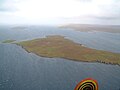
Samphrey
- Area
- 0.81 km²
- High point
- 29 m
St Ninian's Isle
- Area
- 0.72 km²

Oxna
- Area
- 0.71 km²
- High point
- 32 m

Linga
- Area
- 0.63 km²
- High point
- 69 m

South Havra
- Area
- 0.62 km²
- High point
- 42 m

Bruray
- Area
- 0.53 km²
- High point
- 51 m

Lamba
- Area
- 0.51 km²
- High point
- 33 m

Linga
- Area
- 0.49 km²
- High point
- 25 m

Papa
- Area
- 0.44 km²
- High point
- 26 m
Uyea
- Area
- 0.43 km²
- High point
- 67 m

Linga
- Area
- 0.43 km²
- High point
- 39 m

Brother Isle
- Area
- 0.43 km²
- High point
- 24 m

Uynarey
- Area
- 0.27 km²
- High point
- 33 m

Grunay
- Area
- 0.26 km²
- High point
- 25 m
Unnamed island
- Area
- 0.26 km²
- High point
- 29 m

East Linga
- Area
- 0.25 km²
- High point
- 24 m

Little Roe
- Area
- 0.24 km²
- High point
- 24 m
Colsay
- Area
- 0.24 km²
- High point
- 42 m
Linga
- Area
- 0.23 km²
- High point
- 26 m

Huney
- Area
- 0.23 km²
- High point
- 17 m

Haaf Gruney
- Area
- 0.21 km²
- High point
- 17 m
Unnamed island
- Area
- 0.21 km²
- High point
- 37 m

Urie Lingey
- Area
- 0.2 km²
- High point
- 19 m

North Havra
- Area
- 0.19 km²
- High point
- 33 m
Unnamed island
- Area
- 0.18 km²
- High point
- 26 m
South Isle of Gletness
- Area
- 0.17 km²
- High point
- 25 m
Isle of West Burrafirth
- Area
- 0.16 km²
- High point
- 41 m
Cheynies
- Area
- 0.14 km²
- High point
- 18 m

Orfasay
- Area
- 0.14 km²
- High point
- 20 m

Fish Holm
- Area
- 0.14 km²
- High point
- 18 m
Flotta
- Area
- 0.13 km²
- High point
- 10 m
Hoy
- Area
- 0.13 km²
- High point
- 46 m

Lady's Holm
- Area
- 0.13 km²
- High point
- 18 m
Little Havra
- Area
- 0.12 km²
- High point
- 24 m

Lunna Holm
- Area
- 0.12 km²
- High point
- 26 m

Grif Skerry
- Area
- 0.11 km²
- High point
- 21 m
Muckle Holm
- Area
- 0.11 km²
- High point
- 18 m
Linga
- Area
- 0.1 km²
- High point
- 18 m
Brough Holm
- Area
- —
size unknown
Gloup Holm
- Area
- —
size unknown
Rocks & skerries
On the chart above, at its closest zooms.
Listing 66 of 914; the rest are on the chart.
Figures
Comparative heights
- Mainland: 450 m
- Foula: 418 m
- Unst: 285 m
- Bressay: 226 m
- Fair: 217 m
- Yell: 210 m
- Isle of Noss: 181 m
- Muckle Roe: 172 m
- Fetlar: 159 m
- Whalsay: 122 m
- Fora Ness: 100 m
- Vaila: 91 m
- Vementry: 90 m
- Papa Stour: 87 m
To the same scale
Islands by area
| Mainland | 953 km² |
| Yell | 212 km² |
| Unst | 120 km² |
| Fetlar | 40.5 km² |
| Bressay | 27.6 km² |
| Whalsay | 19.5 km² |
| Muckle Roe | 17.2 km² |
| Foula | 13 km² |
| Fair Isle | 8.1 km² |
| Papa Stour | 8.1 km² |
| West Burra | 7.1 km² |
| East Burra | 5 km² |
| Vementry | 3.7 km² |
| Isle of Noss | 3.3 km² |
| Vaila | 3 km² |
| Hascosay | 2.8 km² |
| Trondra | 2.8 km² |
| Uyea | 2.4 km² |
| Papa Little | 2.1 km² |
| Mousa | 1.8 km² |
| Out Skerries | 1.5 km² |
| Fora Ness | 1.4 km² |
| West Linga | 1.2 km² |
| Hildasay | 1 km² |
| Balta | 0.86 km² |
| Bigga | 0.86 km² |
| Samphrey | 0.81 km² |
| St Ninian's Isle | 0.72 km² |
| Oxna | 0.71 km² |
| Linga | 0.63 km² |
| South Havra | 0.62 km² |
| Bruray | 0.53 km² |
| Lamba | 0.51 km² |
| Linga | 0.49 km² |
| Papa | 0.44 km² |
| Uyea | 0.43 km² |
| Linga | 0.43 km² |
| Brother Isle | 0.43 km² |
| Uynarey | 0.27 km² |
| Grunay | 0.26 km² |
| Unnamed island | 0.26 km² |
| East Linga | 0.25 km² |
| Little Roe | 0.24 km² |
| Colsay | 0.24 km² |
| Linga | 0.23 km² |
| Huney | 0.23 km² |
| Haaf Gruney | 0.21 km² |
| Unnamed island | 0.21 km² |
| Urie Lingey | 0.2 km² |
| North Havra | 0.19 km² |
| Unnamed island | 0.18 km² |
| South Isle of Gletness | 0.17 km² |
| Isle of West Burrafirth | 0.16 km² |
| Cheynies | 0.14 km² |
| Orfasay | 0.14 km² |
| Fish Holm | 0.14 km² |
| Flotta | 0.13 km² |
| Hoy | 0.13 km² |
| Lady's Holm | 0.13 km² |
| Little Havra | 0.12 km² |
| Lunna Holm | 0.12 km² |
| Grif Skerry | 0.11 km² |
| Muckle Holm | 0.11 km² |
| Linga | 0.1 km² |
Groups within
Overlapping groups
Photographs

View of the Shetland Islands coast from a sail-boat. Picture taken on the 24th of april in 2013.

Heading to Kirka Ness

Looking the length of Sand Beach from Innersand

Choppy seas near the mouth of Sand Voe

Detached Stack

Loch of Vadill, seaward end

Industrial site by the shore

Looking to Sand from Sand Voe

Sand, Sands in Sand Voe

This is a photo of listed building number

This is a photo of listed building number

Shetland's largest lime kiln
Sources
Facts
Photographs
- Shetland from sailboat. Mænsard Vokser / CC BY-SA 4.0
- Heading to Kirka Ness - geograph.org.uk - 8180859. Iain Lees / CC BY-SA 2.0
- Looking the length of Sand Beach from Innersand - geograph.org.uk - 8180914. Iain Lees / CC BY-SA 2.0
- Choppy seas near the mouth of Sand Voe - geograph.org.uk - 8068547. Gordon Hatton / CC BY-SA 2.0
- Detached Stack - geograph.org.uk - 2632737. Derek Mayes / CC BY-SA 2.0
- Loch of Vadill, seaward end - geograph.org.uk - 4618467. Des Blenkinsopp / CC BY-SA 2.0
- Industrial site by the shore - geograph.org.uk - 8068639. Gordon Hatton / CC BY-SA 2.0
- Looking to Sand from Sand Voe - geograph.org.uk - 8180857. Iain Lees / CC BY-SA 2.0
- Sand, Sands in Sand Voe - geograph.org.uk - 8180909. Iain Lees / CC BY-SA 2.0
- Shetland - Noss Sound broch on Bressay with Gungstie chapel and burial ground on Noss in the background. Ny Björn Gustafsson / CC BY-SA 4.0
- Shetland - Noss Sound broch on Bressay with Noss in the background. Ny Björn Gustafsson / CC BY-SA 4.0
- Shetland's largest lime kiln - geograph.org.uk - 8068650. Gordon Hatton / CC BY-SA 2.0