Pacific OceanCook Islands
10°53′S 165°51′W
Pukapuka
Part of Northern Cook Islands
Pukapuka, formerly Danger Island, is a coral atoll in the northern group of the Cook Islands in the Pacific Ocean. It is one of the most remote islands of the Cook Islands, situated about 1,140 kilometres (708 miles) northwest of Rarotonga.

Chart
Overview
Pukapuka, formerly Danger Island, is a coral atoll in the northern group of the Cook Islands in the Pacific Ocean. It is one of the most remote islands of the Cook Islands, situated about 1,140 kilometres (708 miles) northwest of Rarotonga. On this small island, an ancient culture and distinct language have been maintained over many centuries. The population of Pukapuka is around 400 people.
From Wikipedia, CC BY-SA 4.0
Census, cataloged
Also in the area
Inside the group's outline but not confirmed as members by any source.
- Unnamed island0.15 km²
- Te Aua Loa3 m · 0.11 km²
- Nuku Wetau3 m · 0.09 km²
- Te Alai Loa0.06 km²
- Te Aua Oneone3 m · 0.02 km²
- Unnamed island0.02 km²
- Unnamed island0.01 km²
- Unnamed island0.7 ha
- Unnamed island0.6 ha
- Unnamed island0.5 ha
- Unnamed island0.4 ha
- Te Papa E Taumaya Te Wau2 m · 0.3 ha
Figures
Comparative heights
- Te Aua Loa: 3 m
- Nuku Wetau: 3 m
- Te Aua Oneone: 3 m
- Te Papa E Taumaya Te Wau: 2 m
To the same scale
Islands by area
| Unnamed island | 0.15 km² |
| Te Aua Loa | 0.11 km² |
| Nuku Wetau | 0.09 km² |
| Te Alai Loa | 0.06 km² |
| Te Aua Oneone | 0.02 km² |
| Unnamed island | 0.02 km² |
| Unnamed island | 0.01 km² |
| Unnamed island | 0.7 ha |
| Unnamed island | 0.6 ha |
| Unnamed island | 0.5 ha |
| Unnamed island | 0.4 ha |
| Te Papa E Taumaya Te Wau | 0.3 ha |
Photographs
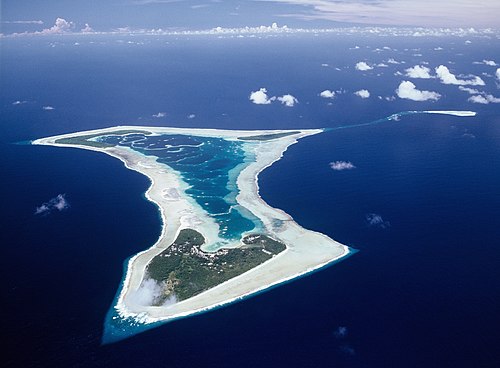
Aerial photograph of Pukapuka Atoll in the Cook Islands, photographed from Air Rarotonga's Embraer Bandeirante Aircraft that infrequently services this remote atoll.

View of the Cook Islands taken during ISS Expedition 2.
Earth Science and Remote Sensing Unit, Lyndon B. Johnson Space Center / Public domain

NASA astronaut image of Pukapuka Atoll (Cook Islands) in the Pacific Ocean

View of the Cook Islands taken during ISS Expedition 2.
Earth Science and Remote Sensing Unit, Lyndon B. Johnson Space Center / Public domain

A solar PV array on Pukapuka, Cook Islands
Sources
Facts
Photographs
- Pukapuka Aerial efs 1280. EwanSmith / CC BY-SA 3.0
- ISS002-E-9622 - View of the Cook Islands. Earth Science and Remote Sensing Unit, Lyndon B. Johnson Space Center / Public domain
- Pukapuka Atoll. NASA / Public domain
- ISS002-E-9915 - View of the Cook Islands. Earth Science and Remote Sensing Unit, Lyndon B. Johnson Space Center / Public domain
- Pukapuka PV 2015. NZ Ministry of Foreign Affairs / New Zealand High Commission, Rarotonga, Cook Islands. MFAT images licenced CC-BY accord / CC BY 4.0