South Pacific OceanNew Zealand and Cook Islands
10°00′S 161°00′W
Northern Cook Islands
Part of Cook Islands
The Northern Cook Islands is one of the two chains of atolls which make up the Cook Islands. Lying in a horizontal band between 9° and 13°30' south of the Equator, the chain consists of the atolls of Manihiki, Nassau, Penrhyn, Pukapuka, Rakahanga and Suwarrow, along with the submerged Tema Reef.

Chart
Overview
The Northern Cook Islands is one of the two chains of atolls which make up the Cook Islands. Lying in a horizontal band between 9° and 13°30' south of the Equator, the chain consists of the atolls of Manihiki, Nassau, Penrhyn, Pukapuka, Rakahanga and Suwarrow, along with the submerged Tema Reef.
From Wikipedia, CC BY-SA 4.0
Census, cataloged
- Major islands4
- Minor islands55
- Islets403
- Rocks & skerries12
Major islands
Nassau
- Area
- 1.2 km²
- High point
- 20 m
Nassau is an island in the northern group of the Cook Islands. It is approximately 1,246 kilometres (774 mi) north of the capital island of Rarotonga and 88 kilometres (55 mi) from Pukapuka coral atoll. Lacking an airstrip, it is accessible only by boat. It is named after a 19th-century whaling ship.
Suwarrow
- Area
- 150 km²
Suwarrow (also called Suvorov, Suvarou, or Suvarov) is an island in the northern group of the Cook Islands in the south Pacific Ocean. It is about 1,300 kilometres (810 mi) south of the equator and 930 kilometres (580 mi) north-northwest of the capital island of Rarotonga.
Penrhyn
- Area
- 9.8 km²
- High point
- 4 m
Penrhyn (also called Tongareva, Māngarongaro, Hararanga, and Te Pitaka) is an atoll in the northern group of the Cook Islands in the south Pacific Ocean. The northernmost island in the group, it is located at 1,365 km (848 mi) north-north-east of the capital island of Rarotonga, 9 degrees south of the equator.
Pukapuka
- Area
- 5 km²
- High point
- 11 m
Pukapuka, formerly Danger Island, is a coral atoll in the northern group of the Cook Islands in the Pacific Ocean. It is one of the most remote islands of the Cook Islands, situated about 1,140 kilometres (708 miles) northwest of Rarotonga.
Minor islands

Aitutaki
- Area
- 15.8 km²
- High point
- 124 m
Manihiki
- Area
- 4 km²
- High point
- 4 m
Rakahanga
- Area
- 4 km²
- High point
- 1 m
Ngake
- Area
- 2.4 km²
- High point
- 26 m
Ruahara
- Area
- 1.8 km²
- High point
- 23 m
Mangarongaro
- Area
- 1.8 km²
- High point
- 23 m
Moananui
- Area
- 1.6 km²
- High point
- 20 m
Unnamed island
- Area
- 1.6 km²
- High point
- 5 m
Motu Ko
- Area
- 1.6 km²
- High point
- 15 m
Pukapuka Island
- Area
- 1.4 km²
- High point
- 18 m
Teutokono
- Area
- 1.3 km²
- High point
- 23 m
Tauhunu
- Area
- 1.3 km²
- High point
- 22 m
Patanga
- Area
- 1.2 km²
- High point
- 21 m
Tokerau
- Area
- 0.73 km²
- High point
- 20 m
Tetaha Kiraro
- Area
- 0.65 km²
- High point
- 21 m
Tepuka
- Area
- 0.56 km²
- High point
- 22 m
Motu Kotawa
- Area
- 0.56 km²
- High point
- 18 m
Kokerekere
- Area
- 0.33 km²
- High point
- 10 m
Matunga
- Area
- 0.29 km²
- High point
- 24 m
Ee
- Area
- 0.28 km²
- High point
- 10 m
Paravae / Hakamaru
- Area
- 0.25 km²
- High point
- 23 m
Porea
- Area
- 0.25 km²
- High point
- 24 m
Motu Oneone
- Area
- 0.24 km²
- High point
- 13 m
Unnamed island
- Area
- 0.24 km²
Unnamed island
- Area
- 0.22 km²
Unnamed island
- Area
- 0.21 km²
Unnamed island
- Area
- 0.21 km²
Motu Tou
- Area
- 0.2 km²
- High point
- 26 m
Motunui
- Area
- 0.19 km²
- High point
- 19 m
Unnamed island
- Area
- 0.17 km²
Unnamed island
- Area
- 0.17 km²
Unnamed island
- Area
- 0.15 km²
Unnamed island
- Area
- 0.14 km²
Atutahi
- Area
- 0.14 km²
- High point
- 23 m
Unnamed island
- Area
- 0.14 km²
Anchorage Island
- Area
- 0.14 km²
- High point
- 20 m
Tuahua
- Area
- 0.14 km²
- High point
- 25 m
Paerangi
- Area
- 0.14 km²
- High point
- 21 m
Murihiti
- Area
- 0.13 km²
- High point
- 24 m
Whale Island
- Area
- 0.13 km²
- High point
- 2 m
Hohake Rahi
- Area
- 0.12 km²
- High point
- 19 m
Angarei
- Area
- 0.12 km²
- High point
- 9 m
Unnamed island
- Area
- 0.12 km²
- High point
- 7 m

Akitua
- Area
- 0.12 km²
- High point
- 13 m
Turtle Island
- Area
- 0.12 km²
- High point
- 19 m
Unnamed island
- Area
- 0.12 km²
Manu Island
- Area
- 0.11 km²
- High point
- 7 m
Nuitikainga
- Area
- 0.11 km²
- High point
- 19 m
Te Aua Loa
- Area
- 0.11 km²
- High point
- 3 m
Unnamed island
- Area
- 0.1 km²
Ahuapapa
- Area
- —
size unknown
Akaro
- Area
- —
- High point
- 1 m
size unknown
Fifinui
- Area
- —
size unknown
High Island
- Area
- —
size unknown
Motu Hakamaru
- Area
- —
- High point
- 22 m
size unknown
Rocks & skerries
On the chart above, at its closest zooms.
Listing 59 of 474; the rest are on the chart.
Figures
Comparative heights
To the same scale
Islands by area
| Suwarrow | 150 km² |
| Aitutaki | 15.8 km² |
| Penrhyn | 9.8 km² |
| Pukapuka | 5 km² |
| Manihiki | 4 km² |
| Rakahanga | 4 km² |
| Ngake | 2.4 km² |
| Ruahara | 1.8 km² |
| Mangarongaro | 1.8 km² |
| Moananui | 1.6 km² |
| Unnamed island | 1.6 km² |
| Motu Ko | 1.6 km² |
| Pukapuka Island | 1.4 km² |
| Teutokono | 1.3 km² |
| Tauhunu | 1.3 km² |
| Nassau | 1.2 km² |
| Patanga | 1.2 km² |
| Tokerau | 0.73 km² |
| Tetaha Kiraro | 0.65 km² |
| Tepuka | 0.56 km² |
| Motu Kotawa | 0.56 km² |
| Kokerekere | 0.33 km² |
| Matunga | 0.29 km² |
| Ee | 0.28 km² |
| Paravae / Hakamaru | 0.25 km² |
| Porea | 0.25 km² |
| Motu Oneone | 0.24 km² |
| Unnamed island | 0.24 km² |
| Unnamed island | 0.22 km² |
| Unnamed island | 0.21 km² |
| Unnamed island | 0.21 km² |
| Motu Tou | 0.2 km² |
| Motunui | 0.19 km² |
| Unnamed island | 0.17 km² |
| Unnamed island | 0.17 km² |
| Unnamed island | 0.15 km² |
| Unnamed island | 0.14 km² |
| Atutahi | 0.14 km² |
| Unnamed island | 0.14 km² |
| Anchorage Island | 0.14 km² |
| Tuahua | 0.14 km² |
| Paerangi | 0.14 km² |
| Murihiti | 0.13 km² |
| Whale Island | 0.13 km² |
| Hohake Rahi | 0.12 km² |
| Angarei | 0.12 km² |
| Unnamed island | 0.12 km² |
| Akitua | 0.12 km² |
| Turtle Island | 0.12 km² |
| Unnamed island | 0.12 km² |
| Manu Island | 0.11 km² |
| Nuitikainga | 0.11 km² |
| Te Aua Loa | 0.11 km² |
| Unnamed island | 0.1 km² |
Groups within
Photographs
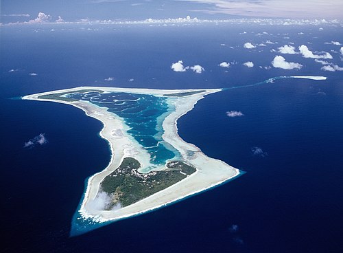
Aerial photograph of Pukapuka Atoll in the Cook Islands, photographed from Air Rarotonga's Embraer Bandeirante Aircraft that infrequently services this remote atoll.

NASA astronaut image of Nassau Island (Cook Islands) in the Pacific Ocean
Sources
Facts
Photographs
- Pukapuka Aerial efs 1280. EwanSmith / CC BY-SA 3.0
- Nassau island. NASA / Public domain
- WV banner North Cook Islands Nassau island from satellite. NASA / Public domain