Pacific OceanJapan
34°20′N 139°40′E
Izu Islands
Part of Tokyo Islands
toː]) are a group of volcanic islands stretching south and east from the Izu Peninsula of Honshū, Japan. Administratively, they form two towns and six villages, all part of Tokyo Metropolis. The largest is Izu Ōshima, usually called simply Ōshima.

Chart
Overview
The Izu Islands (伊豆諸島, Izu Shotō; Japanese pronunciation: [i.(d)zɯ, i.(d)zɯ ɕoꜜ.toː]) are a group of volcanic islands stretching south and east from the Izu Peninsula of Honshū, Japan. Administratively, they form two towns and six villages, all part of Tokyo Metropolis. The largest is Izu Ōshima, usually called simply Ōshima. Although usually called the "Seven Islands of Izu" (伊豆七島 in Japanese), there are in fact more than a dozen islands and islets. Nine among them are currently inhabited.
From Wikipedia, CC BY-SA 4.0
Census, cataloged
- Major islands6
- Minor islands9
- Islets95
- Rocks & skerries842
Major islands
Izu Ōshima
- Area
- 90.8 km²
- High point
- 758 m
Izu Ōshima (伊豆大島, Izu-ōshima) is an inhabited volcanic island in the Izu archipelago and borders Sagami Bay and the Pacific Ocean, off the coast of Honshu, Japan, 22 km (14 mi) east of the Izu Peninsula and 36 km (22 mi) southwest of Bōsō Peninsula.
Hachijō-jima
- Area
- 69.4 km²
- High point
- 854 m
Hachijō-jima (Japanese: 八丈島) is a volcanic island of Japan in the Pacific Ocean. It is about 287 km (178 mi) south of the special wards of Tokyo. It is part of the Izu archipelago and within the Fuji-Hakone-Izu National Park. Its only municipality is Hachijō.
Miyakejima
- Area
- 55.4 km²
- High point
- 775 m
Miyake-jima (三宅島; "Miyake Island") is a volcanic island in the Izu archipelago in the Philippine Sea approximately 180 kilometers (110 mi) southeast of Tokyo, Japan. As with the other islands in the Izu Island group, Miyake-jima forms part of the Fuji-Hakone-Izu National Park.
Nii-jima
- Area
- 23.2 km²
- High point
- 432 m
Nii-jima (新島) is a volcanic Japanese island administered by the Tokyo Metropolitan Government.
Mikura-jima
- Area
- 20.5 km²
- High point
- 851 m
Mikura-jima (御蔵島) is an inhabited volcanic Japanese island in the Pacific Ocean. The island is administered by Tōkyō Metropolis and is located approximately 200 kilometres (120 mi) south of Tokyo and 19 kilometres (12 mi) south-southeast of Miyakejima.
Kōzu-shima
- Area
- 18.5 km²
- High point
- 572 m
Kōzu-shima (神津島) is a volcanic Japanese island in the Philippine Sea. 7 mi) southwest of the Nii-jima. It is one of the Izu Seven Islands, a group of the seven northern islands of the Izu archipelago.


Minor islands
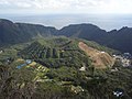
Aogashima
- Area
- 6 km²
- High point
- 423 m

Tori-shima
- Area
- 4.8 km²
- High point
- 394 m
Toshima
- Area
- 4.1 km²
- High point
- 508 m

Shikine-jima
- Area
- 3.7 km²
- High point
- 97 m

Hachijō-kojima
- Area
- 3.1 km²
- High point
- 617 m

Udone-shima
- Area
- 0.41 km²
- High point
- 209 m
Jinai-tō
- Area
- 0.19 km²
- High point
- 77 m
Hanshima
- Area
- 0.11 km²
- High point
- 66 m
Zenisu
- Area
- —
size unknown
Rocks & skerries
On the chart above, at its closest zooms.
Listing 15 of 952; the rest are on the chart.
Figures
Comparative heights
- Hachijō-jima: 854 m
- Mikura-jima: 851 m
- Miyakejima: 775 m
- Izu Ōshima: 758 m
- Hachijō-kojima: 617 m
- Kōzu-shima: 572 m
- Toshima: 508 m
- Nii-jima: 432 m
- Aogashima: 423 m
- Tori-shima: 394 m
- Udone-shima: 209 m
- Shikine-jima: 97 m
- Jinai-tō: 77 m
- Hanshima: 66 m
To the same scale
Islands by area
| Izu Ōshima | 90.8 km² |
| Hachijō-jima | 69.4 km² |
| Miyakejima | 55.4 km² |
| Nii-jima | 23.2 km² |
| Mikura-jima | 20.5 km² |
| Kōzu-shima | 18.5 km² |
| Aogashima | 6 km² |
| Tori-shima | 4.8 km² |
| Toshima | 4.1 km² |
| Shikine-jima | 3.7 km² |
| Hachijō-kojima | 3.1 km² |
| Udone-shima | 0.41 km² |
| Jinai-tō | 0.19 km² |
| Hanshima | 0.11 km² |
Groups within
Photographs

自飛機上拍攝的新島、式根島等島嶼

自飛機上拍攝的新島、早島等島嶼

Minamiizu and Izu Islands seen from Mount Takatoori in Japan.

自飛機上拍攝的早島

A view of Mijura-jima taken from the west.

Tako bay, Kōzushima, Izu Islands, Japan

Crater of Oyama volcano on Miyakejima as seen from aircraft

The white cliffs "Shiro-mama" near the southern end of the beach on the east side of Nii-jima, a volcanic island in Tokyo.

大島のアジサイ

自飛機上拍攝的早島
Sources
Facts
Photographs
- 新島、式根島. Pbdragonwang / CC BY-SA 4.0
- 新島、早島. Pbdragonwang / CC BY-SA 4.0
- Minamiizu and Izu Islands from Mount Takatoori. Alpsdake / CC BY-SA 4.0
- 自飛機上拍攝的早島. Pbdragonwang / CC BY-SA 4.0
- Mikura-jima. Izawa Ryu / CC BY-SA 4.0
- Kozushima Tako Bay 2005. Mkill / CC BY 2.5
- Miyakejima O-Yama Volcano crater. さかおり / CC BY-SA 4.0
- Niijima 20221203 122020. Ka23 13 / CC BY-SA 4.0
- Oshima's Hydrangea (51475096049). Raita Futo from Tokyo, Japan / CC BY 2.0
- 自飛機上拍攝的早島 02. Pbdragonwang / CC BY-SA 4.0
- Minamiizu and Izu Islands from Mount Takatoori (with note). Alpsdake / CC BY-SA 4.0
- WV banner Izu islands Maehama Kozushima. Saigen Jiro / CC0