Celtic SeaUnited Kingdom
49°55′N 6°18′W
Isles of Scilly
Part of British Isles
The Isles of Scilly (, SIL-ee; Cornish: Syllan) are a small archipelago in Cornwall, England, approximately 45 km (28 mi) south-west of Land's End.

Chart
Overview
The Isles of Scilly (, SIL-ee; Cornish: Syllan) are a small archipelago in Cornwall, England, approximately 45 km (28 mi) south-west of Land's End. One of the islands, St Agnes, is over four miles (six kilometres) further south than the most southerly point of the British mainland at Lizard Point, and has the southernmost inhabited settlement in Cornwall and the UK, Troy Town. The total population of the islands at the 2021 United Kingdom census was 2,100 (rounded to the nearest 100). A majority live on one island, St Mary's, and close to half live in Hugh Town; the remainder live on four inhabited "off-islands". People have lived on the islands since at least the Iron Age, and the Romans knew them as Sillina. Rising sea levels flooded low-lying land, and the islands were probably once much larger, possibly a single island. In the Middle Ages they belonged to Tavistock Abbey, which founded a priory on Tresco. During the English Civil War they were a Royalist base until Parliament captured them in 1651. In 1707, four Royal Navy ships were wrecked off the islands, and at least 1,450 people died. Most of the islands were held on lease, first by the Godolphin family and later by the Smith family, until 1920, when they passed back to the Duchy of Cornwall. The islands are known for pilot gig racing, a rowing sport that began with crews racing to put pilots on ships. The World Pilot Gig Championships are held there every year over the May Day bank holiday weekend. The islands have what is reportedly the world's smallest football league. A 2006 survey found that residents were the most active in England for sport and fitness. Rock climbing and bouldering on the granite coast have been practised since 1977. The islands have also featured on television, including in the BBC series An Island Parish. Scilly forms part of the ceremonial county of Cornwall and was historically one of the hundreds of Cornwall. Since 1890, the islands have had their own local authority, the Council of the Isles of Scilly, which is administratively separate from the mainland Cornwall Council, although some services are provided by it. The adjective "Scillonian" is sometimes used for people or things related to the archipelago. The Duchy of Cornwall owns most of the freehold land on the islands. Tourism is a major part of the local economy along with agriculture, particularly the production of cut flowers.
From Wikipedia, CC BY-SA 4.0
Census, cataloged
- Major islands4
- Minor islands13
- Islets73
- Rocks & skerries625
Major islands
St Mary's
- Area
- 6.4 km²
- High point
- 51 m
St Mary's (Cornish: An Nor, lit. 'the land') is the largest and most populous island of the Isles of Scilly, an archipelago in Cornwall, England, United Kingdom.
Tresco
- Area
- 3 km²
- High point
- 34 m
Tresco (Cornish: Enys Skaw, lit. 'island of elder-trees') is the second-biggest island of the Isles of Scilly. It is 297 ha (1.15 sq mi) in area, measuring about 3.5 km (2.2 mi) by 1.75 km (1.09 mi).
St Martin's
- Area
- 2.2 km²
- High point
- 46 m
St Martin's (Cornish: Breghyek, lit. 'dappled island') is the northernmost populated island of the Isles of Scilly, Cornwall, England, United Kingdom. 92 sq mi) and a total population (2021 census) of 135. Four regions of the island are designated as Sites of Special Scientific Interest.
St Agnes, Isles of Scilly
- Area
- 1.1 km²
- High point
- 15 m
St Agnes (Cornish: Agenys) is the southernmost populated island of the Isles of Scilly. Thus the island's Troy Town Farm is the southernmost settlement in the United Kingdom.


Minor islands

Bryher
- Area
- 1.2 km²
- High point
- 42 m

Gugh
- Area
- 0.38 km²
- High point
- 30 m

Samson
- Area
- 0.38 km²
- High point
- 38 m
Annet
- Area
- 0.22 km²
- High point
- 17 m
St Helen's
- Area
- 0.19 km²
- High point
- 44 m

Teän
- Area
- 0.16 km²
- High point
- 28 m

White Island
- Area
- 0.15 km²
- High point
- 28 m

Great Ganilly
- Area
- 0.13 km²
- High point
- 31 m
Biggal of Gorregan
- Area
- —
size unknown
Hellweathers
- Area
- —
size unknown
Moths Ledge
- Area
- —
size unknown
Retarrier Ledges
- Area
- —
size unknown
The Brow
- Area
- —
size unknown
Rocks & skerries
On the chart above, at its closest zooms.
Listing 17 of 715; the rest are on the chart.
Figures
Comparative heights
- St Mary's: 51 m
- St Martin's: 46 m
- St Helen's: 44 m
- Bryher: 42 m
- Samson: 38 m
- Tresco: 34 m
- Great Ganilly: 31 m
- Gugh: 30 m
- Teän: 28 m
- White: 28 m
- Annet: 17 m
- St Agnes, Isles of Scilly: 15 m
To the same scale
Islands by area
| St Mary's | 6.4 km² |
| Tresco | 3 km² |
| St Martin's | 2.2 km² |
| Bryher | 1.2 km² |
| St Agnes, Isles of Scilly | 1.1 km² |
| Gugh | 0.38 km² |
| Samson | 0.38 km² |
| Annet | 0.22 km² |
| St Helen's | 0.19 km² |
| Teän | 0.16 km² |
| White Island | 0.15 km² |
| Great Ganilly | 0.13 km² |
Groups within
Photographs
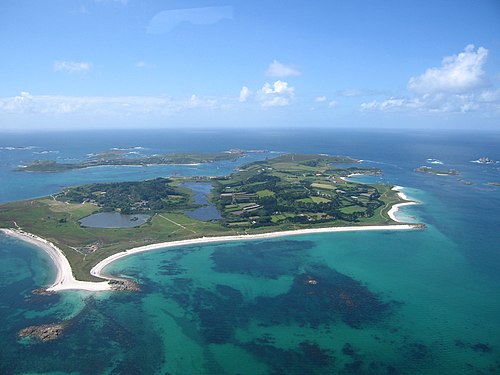
Looking across Tresco, one of the five inhabited islands of the Isles of Scilly 45 km (28 miles) from the coast of Cornwall in the United Kingdom. Photo taken from a helicopter using a Canon PowerShot S70 camera in June 2005.

An aerial photo of the Isles of Scilly, Great Britain.

North view from Normandy Down (also known as Deep Point) towards Toll's Island with St Martin's in the background.

Central Mincarlo

Coming into land on the Scillies - showing the Eastern Isles

Biggal rock

The south and east sides of the Five Islands Academy from the main gate of the school.

Hanjague

Islands in the Scillies from the air

The Isles of Health and Wellbeing centre, with the islands sports hall on the right. The building on the left was previously the island primary school.

Isles of Scilly: The Western Rocks from Gorregan

Men A Vaur Isles of Scilly by Kernow Skies
Sources
Facts
Photographs
- Tresco - aerial photo6. Tom Corser / CC BY-SA 3.0
- Isles of Scilly NASA. ISS Crew Earth Observations experiment and the Image Science & Analysis Laboratory, Johnson Space Center / Public domain
- Normandy Down July 2026 02. ArildV / CC BY-SA 4.0
- Central Mincarlo - geograph.org.uk - 8068063. Des Blenkinsopp / CC BY-SA 2.0
- Coming into land on the Scillies - showing the Eastern Isles. Kernow Skies / CC BY-SA 3.0
- Biggal rock - geograph.org.uk - 5777312. Andrew Abbott / CC BY-SA 2.0
- Five Islands Academy. HenryTemplo / CC BY-SA 4.0
- Hanjague - geograph.org.uk - 8063246. Des Blenkinsopp / CC BY-SA 2.0
- Islands in the Scillies from the air. Kernow Skies / CC BY-SA 3.0
- Isles of Scilly Health and Wellbeing Centre. HenryTemplo / CC BY-SA 4.0
- Isles of Scilly, The Western Rocks from Gorregan - geograph.org.uk - 7865009. Michael Earnshaw / CC BY-SA 2.0
- Men A Vaur Isles of Scilly by Kernow Skies. Kernow Skies / CC BY-SA 3.0