Ionian SeaGreece and Albania
37°48′N 20°42′E
Ionian Islands
Επτάνησα
The Ionian Islands (Modern Greek: Ιόνια νησιά, Ionia nisia; Ancient Greek, Katharevousa: Ἰόνιαι Νῆσοι, Ioniai Nēsoi) are a group of islands in the Ionian Sea, west of mainland Greece.

Chart
Overview
The Ionian Islands (Modern Greek: Ιόνια νησιά, Ionia nisia; Ancient Greek, Katharevousa: Ἰόνιαι Νῆσοι, Ioniai Nēsoi) are a group of islands in the Ionian Sea, west of mainland Greece. They are traditionally called the Heptanese ("Seven Islands"; Ἑπτάνησα, Heptanēsa or Ἑπτάνησος, Heptanēsos; Italian: Eptaneso), but the group includes many smaller islands in addition to the seven principal ones. As a distinct historic region, the collective of islands dates to the centuries-long Venetian rule, which kept them outside Ottoman control, and created a distinct cultural identity with many Italian influences. The Ionian Islands became part of the modern Greek state in 1864. Administratively today, they belong to the Ionian Islands Region except for Kythera, which belongs to the Attica Region.
From Wikipedia, CC BY-SA 4.0
Census, cataloged
- Major islands5
- Minor islands62
- Islets237
- Rocks & skerries2,609
Major islands
Cephalonia
- Area
- 780 km²
- High point
- 1,628 m
Kefalonia or Cephalonia (Greek: Κεφαλονιά [kefaloˈɲa]), formerly also known as Kefallinia or Kephallenia (Κεφαλληνία), is the largest of the Ionian Islands in western Greece and the sixth-largest island in Greece after Crete, Euboea, Lesbos, Rhodes and Chios.
Corfu
- Area
- 590 km²
- High point
- 906 m
Corfu ( kor-FOO, -FEW, US also KOR-foo, -few) or Kerkyra is one of the Ionian Islands in western Greece, and the northernmost island on Greece's west coast except for its satellite Diapontian Islands, which are also the westernmost point of all Greece.
Zakynthos
- Area
- 406 km²
- High point
- 756 m
Zakynthos, also known as Zante, is a Greek island in the Ionian Sea. It is the third largest of the Ionian Islands, with an area of 405.55 km2 (156.6 sq mi), and a coastline 123 km (76 mi) in length. In Greek mythology, the island was said to be named after Zacynthus, the son of the legendary Arcadian chief Dardanus.
Lefkada
- Area
- 301 km²
- High point
- 1,182 m
Lefkada (Greek: Λευκάδα, Lefkáda, [lefˈkaða]), also known as Lefkas or Leukas (Ancient Greek and Katharevousa: Λευκάς, Leukás, modern pronunciation Lefkás) and Leucadia, is a Greek island in the Ionian Sea on the west coast of Greece, connected to the mainland by a long causeway and floating bridge.
Kythira
- Area
- 277 km²
- High point
- 505 m
Kythira ( kih-THEER-ə, KITH-irr-ə; Greek: Κύθηρα [ˈciθira]), also transliterated as Cythera, Kythera and Kithira, is an island in Greece lying opposite the south-eastern tip of the Peloponnese peninsula. It is traditionally listed as one of the seven main Ionian Islands, although it is distant from the main group.


Minor islands

Ithaca
- Area
- 95.7 km²
- High point
- 809 m

Kalamos
- Area
- 25 km²
- High point
- 745 m

Antikythera
- Area
- 20.5 km²
- High point
- 365 m

Paxos
- Area
- 20.4 km²
- High point
- 233 m

Meganisi
- Area
- 19.8 km²
- High point
- 295 m
Elafonisos
- Area
- 17.9 km²
- High point
- 269 m
Schiza
- Area
- 12 km²
- High point
- 200 m

Othonoi
- Area
- 10.6 km²
- High point
- 393 m

Sapientza
- Area
- 9.1 km²
- High point
- 229 m
Kastos
- Area
- 5.8 km²
- High point
- 153 m
Petalas
- Area
- 5.4 km²
- High point
- 248 m

Atokos
- Area
- 4.5 km²
- High point
- 330 m

Arkoudi
- Area
- 4.2 km²
- High point
- 138 m

Oxeia
- Area
- 4.2 km²
- High point
- 389 m

Ereikoussa
- Area
- 3.6 km²
- High point
- 123 m
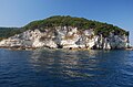
Antipaxos
- Area
- 3.6 km²
- High point
- 117 m
Sphacteria
- Area
- 3.1 km²
- High point
- 147 m
Proti Island
- Area
- 3 km²
- High point
- 186 m
Mathraki
- Area
- 2.8 km²
- High point
- 147 m
Drakonera
- Area
- 2.4 km²
- High point
- 126 m

Stamfani
- Area
- 1.2 km²
- High point
- 29 m
Prováti
- Area
- 1.2 km²
- High point
- 55 m
Vromonas
- Area
- 0.99 km²
- High point
- 141 m
Makri
- Area
- 0.95 km²
- High point
- 121 m
Venetiko
- Area
- 0.93 km²
- High point
- 153 m

Skorpios
- Area
- 0.87 km²
- High point
- 82 m
Kythros
- Area
- 0.75 km²
- High point
- 93 m

Syvota islet
- Area
- 0.75 km²
- High point
- 115 m
Pontikos
- Area
- 0.72 km²
- High point
- 60 m
Karlonisi
- Area
- 0.69 km²
- High point
- 75 m
Sparti
- Area
- 0.54 km²
- High point
- 52 m
Agios Nikolaos islet
- Area
- 0.53 km²
- High point
- 65 m

Vido
- Area
- 0.52 km²
- High point
- 48 m
Santa Marina
- Area
- 0.51 km²
- High point
- 31 m
Dragonera
- Area
- 0.4 km²
- High point
- 34 m
Makrykythra
- Area
- 0.38 km²
- High point
- 33 m
Lamprinos
- Area
- 0.34 km²
- High point
- 59 m
Pori
- Area
- 0.32 km²
- High point
- 149 m
Diaplo
- Area
- 0.31 km²
- High point
- 33 m
Chytra
- Area
- 0.27 km²
- High point
- 180 m
Modi
- Area
- 0.26 km²
- High point
- 64 m
Marathonisi
- Area
- 0.24 km²
- High point
- 126 m
Kalami
- Area
- 0.23 km²
- High point
- 2 m
Kalogiros
- Area
- 0.23 km²
- High point
- 33 m

Vardianoi
- Area
- 0.21 km²
- High point
- 18 m
Arpyia
- Area
- 0.18 km²
- High point
- 13 m
Agios Nikolaos
- Area
- 0.18 km²
- High point
- 43 m
Mourtemeno
- Area
- 0.17 km²
- High point
- 33 m

Pelouzo
- Area
- 0.17 km²
- High point
- 73 m
Andidhragonera
- Area
- 0.17 km²
- High point
- 27 m
Sofía
- Area
- 0.16 km²
- High point
- 35 m

Thilia
- Area
- 0.14 km²
- High point
- 34 m
Vouvalos
- Area
- 0.13 km²
- High point
- 18 m
Unnamed island
- Area
- 0.12 km²
- High point
- 29 m

Skorpidi
- Area
- 0.12 km²
- High point
- 30 m
Pistros
- Area
- 0.11 km²
- High point
- 39 m

Madouri
- Area
- 0.11 km²
- High point
- 42 m
Prasoudi
- Area
- 0.11 km²
- High point
- 28 m
Kaltsonisi
- Area
- 0.11 km²
- High point
- 41 m
Provati
- Area
- 0.11 km²
- High point
- 40 m
Unnamed island
- Area
- —
size unknown
Dulichium
- Area
- —
size unknown
Rocks & skerries
On the chart above, at its closest zooms.
Listing 67 of 2913; the rest are on the chart.
Figures
Comparative heights
- Cephalonia: 1,628 m
- Lefkada: 1,182 m
- Corfu: 906 m
- Ithaca: 809 m
- Zakynthos: 756 m
- Kalamos: 745 m
- Kythira: 505 m
- Othonoi: 393 m
- Oxeia: 389 m
- Antikythera: 365 m
- Atokos: 330 m
- Meganisi: 295 m
- Elafonisos: 269 m
- Petalas: 248 m
To the same scale
Islands by area
Groups within
Overlapping groups
Photographs
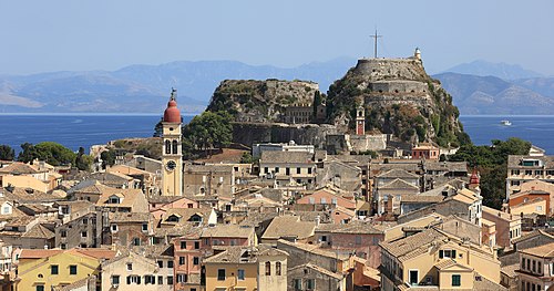
The Old Fortress and the Old Town of Corfu - part of UNESCO World Heritage Site Ref. Number 978.

Asos, Kefalonia, Greece.

View on Kapsali, Island of Kythira

This is a photograph of a Natura 2000 protected area with ID

This is a photograph of a Natura 2000 protected area with ID

Greece_Corfu_Island_-_Capital_Kérkira_2

Lefkada town from the hill

This is a photograph of a Natura 2000 protected area with ID

This is a photograph of a Natura 2000 protected area with ID

This is a photograph of a Natura 2000 protected area with ID

This is a photograph of a Natura 2000 protected area with ID

This is a photograph of a Natura 2000 protected area with ID
Sources
Facts
Photographs
- The Old Fortress and the Old Town of Corfu - September 2017. Martin Falbisoner / CC BY-SA 4.0
- Asos, Kefalonia. Matt Sims / CC BY 2.0
- Kythira - Kapsali. Ingo Mehling / CC BY-SA 3.0
- "Πόρτο Σέληνας", Βορειοδυτική Ζάκυνθος. Spyros L. / CC BY-SA 4.0
- "Πόρτο Λιμνιώνας", Δυτική Ζάκυνθος. Spyros L. / CC BY-SA 4.0
- Greece Corfu Island - Capital Kérkira 2. Hedwig Storch / CC BY-SA 3.0
- Lefkada-2007. ERWEH / CC BY-SA 2.0 de
- Cameo Island. Agapi K.Patiri / CC BY-SA 4.0
- DIM 0389. Dimitris Chaikalis / CC BY-SA 4.0
- DIM 1011. Dimitris Chaikalis / CC BY-SA 4.0
- DSC 0063a. Dora Sidiropoulou Kasimati / CC BY-SA 4.0
- DSC 0065a. Dora Sidiropoulou Kasimati / CC BY-SA 4.0