Florida StraitUnited States
24°40′N 81°33′W
Florida Keys
The Florida Keys are a coral cay archipelago off the southern coast of Florida, forming the southernmost part of the continental United States.

Chart
Overview
The Florida Keys are a coral cay archipelago off the southern coast of Florida, forming the southernmost part of the continental United States. They begin at the southeastern coast of the Florida peninsula, about 15 miles (24 km) south of Miami and extend in an arc south-southwest and then westward to Key West, the westernmost of the inhabited islands, and on to the uninhabited Dry Tortugas. The islands lie along the Florida Straits, dividing the Atlantic Ocean to the east from the Gulf of Mexico to the northwest, and defining one edge of Florida Bay. The southern part of Key West is 93 miles (150 km) from Cuba. The Keys are located between about 24.3 and 25.5 degrees north latitude. More than 95% of the land area lies in Monroe County, but a small portion extends northeast into Miami-Dade County, such as Totten Key. The total land area is 137.3 square miles (356 km2). At the 2010 census the population was 73,090, with an average density of 532.34 per square mile (205.54/km2), although much of the population is concentrated in a few areas of much higher density, such as the city of Key West, which has 32% of the Keys' total population. The 2014 Census population estimate was 77,136. The 2020 Census population estimate was 82,874. The city of Key West is the county seat of Monroe County. The county consists of a section on the mainland which is almost entirely in Everglades National Park, and the Keys islands from Key Largo to Dry Tortugas National Park.
From Wikipedia, CC BY-SA 4.0
Census, cataloged
- Major islands49
- Minor islands210
- Islets997
- Rocks & skerries810
Major islands
Key Largo
- Area
- 88.8 km²
- High point
- 3 m
Key Largo (Spanish: Cayo Largo) is an island in the upper Florida Keys archipelago and is the largest section of the keys, at 33 miles (53 km) long. S. Highway 1 (the Overseas Highway).
Big Pine Key
- Area
- 25.2 km²
- High point
- 10 m
Boca Chica Key
- Area
- 16.1 km²
- High point
- 15 m
6 km) east of the island of Key West at its closest point. Its name is Spanish for "small mouth". It is mostly covered by salt marshes and mangrove trees, and is the home of the largest Naval Air Station (NAS Key West) in south Florida. S. a. Geiger Beach) on Boca Chica Road.
Cudjoe Key
- Area
- 13.9 km²
- High point
- 14 m
Key West
- Area
- 12.7 km²
- High point
- 17 m
S. state of Florida and its outlying Florida Keys archipelago. Together with all or parts of the separate islands of Dredgers Key, Fleming Key, Sunset Key, and the northern part of Stock Island, it constitutes the City of Key West.
Sugarloaf Key
- Area
- 11.3 km²
- High point
- 10 m
Sugarloaf Key is a single island in the lower Florida Keys that forms a loop on the Atlantic Ocean side, giving the illusion of separate islands.
Plantation Key
- Area
- 7.7 km²
- High point
- 16 m
Plantation Key is an island in Monroe County, Florida, United States. It is located in the upper Florida Keys on U.S. 1 (or the Overseas Highway), between Key Largo and Windley Key.
Totten Key
- Area
- 7.4 km²
- High point
- 12 m
Totten Key is an island of the upper Florida Keys in Biscayne National Park. It is in Miami-Dade County, Florida.
Fiesta Key
- Area
- 5.1 km²
- High point
- 15 m
Fiesta Key is the northeasternmost island in the middle Florida Keys, connected via causeway to U.S. 1 (or the Overseas Highway) at mile marker 70, between Long Key and Craig Key.
Stock Island
- Area
- 4.4 km²
- High point
- 27 m
Stock Island is an island in the lower Florida Keys immediately east of Key West (separated from Key West by Cow Key Channel, which is only about 75 yards (70 m) wide). Immediately northwest is Key Haven (official name Raccoon Key), from which it is connected by causeway with US 1 (the Overseas Highway). S.
Ramrod Key
- Area
- 4.3 km²
- High point
- 8 m
Ramrod Key is an island in the lower Florida Keys. Originally named Roberts Island, Ramrod Key was renamed for a ship named Ramrod, which was wrecked on a reef south of there in the early nineteenth century.
Upper Matecumbe Key
- Area
- 3.9 km²
- High point
- 15 m
Upper Matecumbe Key is an island in the upper Florida Keys.
Lower Matecumbe Key
- Area
- 3.8 km²
- High point
- 14 m
Lower Matecumbe Key is an island in the upper Florida Keys, United States, located on U.S. 1 between mile markers 73–78.
Boot Key
- Area
- 3.3 km²
- High point
- 11 m
Boot Key is an island in the middle Florida Keys located adjacent to Key Vaca. Boot Key is within the city limits of Marathon, Florida, United States. The island is largely undeveloped. A draw bridge that once connected the island to Key Vaca was demolished by the city in 2010 after failing FDOT's inspection.
Summerland Key
- Area
- 3.1 km²
- High point
- 9 m
Summerland Key is an island in the lower Florida Keys about 20 miles (32 km) east of Key West; it contains an unincorporated community of Monroe County of the same name.
Big Coppitt Key
- Area
- 2.2 km²
- High point
- 7 m
Big Coppitt Key is an island in Monroe County, Florida, United States, in the lower Florida Keys. The name is said to be a derivation of the old English word "coppice", meaning thicket. D. Bache, in the notes for his coast survey conducted in 1861, this key was the location of Happy Jack's plantation in 1855.
Bahia Honda Key
- Area
- 2 km²
- High point
- 11 m
Bahia Honda ( BAY-ə HON-də, Spanish: [baˈia ˈonda]; lit. 'deep bay') is an island in the lower Florida Keys.
Lower Sugarloaf Key
- Area
- 1.7 km²
- High point
- 7 m
Windley Key
- Area
- 1.7 km²
- High point
- 13 m
Windley Key is an island in the upper Florida Keys in Monroe County, Florida, United States. S. 5, between Plantation Key and Upper Matecumbe Key. All of the key is within the Village of Islamorada as of November 4, 1997, when it was incorporated.


Hog Key
- Area
- 9.6 km²
- High point
- 12 m
Boggy Key
- Area
- 9.4 km²
- High point
- 9 m
Elliott Key
- Area
- 7.1 km²
- High point
- 11 m
Elliott Key is the northernmost of the true Florida Keys (those 'keys' which are ancient coral reefs lifted above the present sea level), and the largest key north of Key Largo. It is located entirely within Biscayne National Park, in Miami-Dade County, Florida, east of Homestead, Florida.
Unnamed island
- Area
- 7 km²
- High point
- 7 m
Unnamed island
- Area
- 5.1 km²
- High point
- 11 m
Unnamed island
- Area
- 4.9 km²
- High point
- 7 m
No Name Key
- Area
- 4.8 km²
- High point
- 10 m
No Name Key is an island in the lower Florida Keys in the United States. 8 km) from US 1 and sparsely populated, with only 43 homes. It is only about 1,140 acres (460 hectares) in comparison to its larger neighbor, Big Pine Key, which lies about half a mile (800 m) to its west.
Howe Key
- Area
- 3.8 km²
- High point
- 9 m
Grassy Key
- Area
- 3.7 km²
Grassy Key, Florida, is an island in the middle Florida Keys. It is located on U.S. 1 (or the Overseas Highway), near mile markers 57—60, below the Conch Keys. It has an area of 3.65 km², with a population of 974 as of the census 2000.
Little Pine Key
- Area
- 3.2 km²
- High point
- 8 m
Unnamed island
- Area
- 3.2 km²
- High point
- 8 m
Unnamed island
- Area
- 2.7 km²
- High point
- 4 m
Unnamed island
- Area
- 2.6 km²
- High point
- 9 m
Knockemdown Key
- Area
- 2.5 km²
- High point
- 7 m
Knockemdown Key is an island in the lower Florida Keys approximately 20 miles (32 km) east of Key West. It is northwest of Summerland Key, between Cudjoe Key and Big Torch Key.
Annette Key
- Area
- 1.8 km²
- High point
- 10 m
Sands Key
- Area
- 1.7 km²
- High point
- 9 m
Sands Key is an island north of the upper Florida Keys in Biscayne National Park. It is in Miami-Dade County, Florida.
Snipe Keys
- Area
- 1.7 km²
- High point
- 11 m
Eagle Key
- Area
- 1.7 km²
- High point
- 7 m
Cutoe Key
- Area
- 1.5 km²
- High point
- 8 m
Unnamed island
- Area
- 1.4 km²
- High point
- 2 m
Geiger Key
- Area
- 1.3 km²
- High point
- 7 m
Geiger Key is an island in the lower Florida Keys about 5 miles (8 km) east of Key West.
Johnston Key
- Area
- 1.3 km²
- High point
- 6 m
Little Knockemdown Key
- Area
- 1.2 km²
- High point
- 7 m
Manatee Key
- Area
- 1.2 km²
- High point
- 7 m
Sigsbee Park
- Area
- 1.2 km²
Sigsbee Park, also known as Dredgers Key, is an island about half a mile (800 m) north of Key West island in the lower Florida Keys; administratively it is within the City of Key West, Florida, United States.
Water Key
- Area
- 1.1 km²
- High point
- 10 m
Minor islands
Russell Key
- Area
- 1.1 km²
- High point
- 4 m

Lignumvitae Key
- Area
- 1.1 km²
- High point
- 16 m
Unnamed island
- Area
- 1.1 km²
- High point
- 8 m

Fleming Key
- Area
- 1 km²
- High point
- 11 m
Johnson Keys
- Area
- 1 km²
- High point
- 9 m
Unnamed island
- Area
- 1 km²
- High point
- 7 m
Unnamed island
- Area
- 0.97 km²
- High point
- 12 m
Raccoon Key
- Area
- 0.88 km²
- High point
- 7 m
Boca Grande Key
- Area
- 0.85 km²
- High point
- 5 m
Palo Alto Key
- Area
- 0.84 km²
- High point
- 11 m
Lake Key
- Area
- 0.83 km²
- High point
- 5 m
Unnamed island
- Area
- 0.79 km²
- High point
- 5 m
Shell Key
- Area
- 0.79 km²
- High point
- 8 m
Unnamed island
- Area
- 0.75 km²
- High point
- 6 m
Deer Key
- Area
- 0.7 km²
- High point
- 3 m
Unnamed island
- Area
- 0.69 km²
- High point
- 8 m
Unnamed island
- Area
- 0.69 km²
- High point
- 4 m
Horseshoe Keys
- Area
- 0.68 km²
- High point
- 9 m
Big Key
- Area
- 0.68 km²
- High point
- 5 m
Dreguez Key
- Area
- 0.67 km²
- High point
- 10 m
Rattlesnake Key
- Area
- 0.67 km²
- High point
- 10 m
Unnamed island
- Area
- 0.65 km²
- High point
- 3 m
Palm Key
- Area
- 0.64 km²
- High point
- 10 m
Rodriguez Key
- Area
- 0.61 km²
- High point
- 16 m
Unnamed island
- Area
- 0.6 km²
- High point
- 6 m
Unnamed island
- Area
- 0.6 km²
- High point
- 8 m
Stake Key
- Area
- 0.59 km²
- High point
- 7 m
Main Key
- Area
- 0.58 km²
- High point
- 11 m
Unnamed island
- Area
- 0.57 km²
- High point
- 3 m
Unnamed island
- Area
- 0.56 km²
- High point
- 1 m
Water Key
- Area
- 0.55 km²
- High point
- 8 m
Unnamed island
- Area
- 0.55 km²
- High point
- 2 m
Unnamed island
- Area
- 0.55 km²
- High point
- 9 m
Club Key
- Area
- 0.55 km²
- High point
- 5 m
Unnamed island
- Area
- 0.53 km²
- High point
- 6 m
Unnamed island
- Area
- 0.53 km²
- High point
- 4 m
Unnamed island
- Area
- 0.53 km²
- High point
- 5 m
North Nest Key
- Area
- 0.52 km²
- High point
- 3 m
Barracouta Key
- Area
- 0.52 km²
- High point
- 5 m
Saddlehill Key
- Area
- 0.52 km²
- High point
- 10 m
Unnamed island
- Area
- 0.5 km²
- High point
- 9 m
Long Arsenicker Key
- Area
- 0.49 km²
- High point
- 11 m
Unnamed island
- Area
- 0.49 km²
Unnamed island
- Area
- 0.48 km²
- High point
- 4 m
Big Munson Island
- Area
- 0.47 km²
- High point
- 8 m
Corinne Key
- Area
- 0.45 km²
- High point
- 4 m

Duck Key
- Area
- 0.45 km²
- High point
- 7 m
Unnamed island
- Area
- 0.44 km²
- High point
- 2 m
Unnamed island
- Area
- 0.44 km²
- High point
- 6 m
Rankin Key
- Area
- 0.43 km²
- High point
- 5 m
Shell Key
- Area
- 0.42 km²
- High point
- 5 m

Scout Key
- Area
- 0.41 km²
- High point
- 8 m
Unnamed island
- Area
- 0.41 km²
- High point
- 8 m
Unnamed island
- Area
- 0.4 km²
- High point
- 6 m
Unnamed island
- Area
- 0.4 km²
- High point
- 6 m
Bottle Key
- Area
- 0.4 km²
- High point
- 5 m
Lois Key
- Area
- 0.4 km²
- High point
- 7 m
Little Spanish Key
- Area
- 0.39 km²
- High point
- 9 m
Unnamed island
- Area
- 0.38 km²
- High point
- 4 m
Unnamed island
- Area
- 0.38 km²
- High point
- 7 m
Unnamed island
- Area
- 0.37 km²
- High point
- 4 m
Unnamed island
- Area
- 0.36 km²
- High point
- 5 m
Frank Key
- Area
- 0.36 km²
- High point
- 10 m
Joe Kemp Key
- Area
- 0.35 km²
- High point
- 9 m
Panhandle Key
- Area
- 0.34 km²
- High point
- 10 m
Mayo Key
- Area
- 0.34 km²
- High point
- 7 m
Rubicon Keys
- Area
- 0.34 km²
- High point
- 4 m
Unnamed island
- Area
- 0.34 km²
Unnamed island
- Area
- 0.33 km²
- High point
- 2 m
Unnamed island
- Area
- 0.33 km²
- High point
- 7 m
Toptree Hammock Key
- Area
- 0.33 km²
- High point
- 5 m
Woman Key
- Area
- 0.32 km²
- High point
- 4 m

Adams Key
- Area
- 0.32 km²
- High point
- 7 m
Ohio Key
- Area
- 0.32 km²
- High point
- 8 m
Murray Key
- Area
- 0.31 km²
- High point
- 11 m
Park Key
- Area
- 0.31 km²
- High point
- 4 m
Porgy Key
- Area
- 0.3 km²
- High point
- 8 m
Unnamed island
- Area
- 0.3 km²
- High point
- 4 m
Rhiannon Key
- Area
- 0.29 km²
- High point
- 8 m
Lower Sugarloaf Key
- Area
- 0.29 km²
- High point
- 3 m
Unnamed island
- Area
- 0.29 km²
- High point
- 4 m
Unnamed island
- Area
- 0.28 km²
- High point
- 3 m
Unnamed island
- Area
- 0.28 km²
- High point
- 4 m
Unnamed island
- Area
- 0.28 km²
- High point
- 3 m
Unnamed island
- Area
- 0.28 km²
- High point
- 9 m
Unnamed island
- Area
- 0.28 km²
- High point
- 5 m
Unnamed island
- Area
- 0.27 km²
- High point
- 7 m
Big Spanish Key
- Area
- 0.27 km²
- High point
- 9 m
Cayo Agua
- Area
- 0.26 km²
- High point
- 5 m
Sawyer Key
- Area
- 0.25 km²
- High point
- 4 m
O'Hara Key
- Area
- 0.25 km²
- High point
- 4 m
Halfmoon Key
- Area
- 0.25 km²
- High point
- 7 m
Conch Key
- Area
- 0.25 km²
- High point
- 7 m
End Key
- Area
- 0.24 km²
- High point
- 5 m
Unnamed island
- Area
- 0.24 km²
- High point
- 9 m
Unnamed island
- Area
- 0.24 km²
- High point
- 9 m
Unnamed island
- Area
- 0.23 km²
- High point
- 4 m
Cook Island
- Area
- 0.23 km²
- High point
- 9 m
Cottrell Key
- Area
- 0.23 km²
- High point
- 7 m
Unnamed island
- Area
- 0.22 km²
- High point
- 4 m
Unnamed island
- Area
- 0.22 km²
- High point
- 8 m
West Key
- Area
- 0.22 km²
- High point
- 10 m
Park Key
- Area
- 0.22 km²
- High point
- 3 m
East Bahia Honda Key
- Area
- 0.22 km²
- High point
- 11 m
Unnamed island
- Area
- 0.22 km²
- High point
- 3 m
Unnamed island
- Area
- 0.22 km²
- High point
- 11 m
Sid Key
- Area
- 0.21 km²
- High point
- 5 m
Unnamed island
- Area
- 0.21 km²
- High point
- 4 m

Loggerhead Key
- Area
- 0.21 km²
- High point
- 3 m
Content Keys
- Area
- 0.21 km²
- High point
- 6 m
Unnamed island
- Area
- 0.21 km²
- High point
- 5 m
Unnamed island
- Area
- 0.21 km²
- High point
- 6 m
West Harbor Key
- Area
- 0.2 km²
- High point
- 4 m
Jim Foot Key
- Area
- 0.2 km²
- High point
- 5 m
Broad Key
- Area
- 0.2 km²
- High point
- 3 m
Archer Key
- Area
- 0.2 km²
- High point
- 6 m
Buoy Key
- Area
- 0.2 km²
- High point
- 5 m
Unnamed island
- Area
- 0.19 km²
- High point
- 6 m
Man Key
- Area
- 0.19 km²
- High point
- 4 m
Content Key
- Area
- 0.19 km²
- High point
- 5 m
Captain Key
- Area
- 0.19 km²
- High point
- 4 m
Butternut Key
- Area
- 0.19 km²
- High point
- 7 m
Unnamed island
- Area
- 0.19 km²
- High point
- 6 m
Unnamed island
- Area
- 0.18 km²
- High point
- 8 m
Roscoe Key
- Area
- 0.18 km²
- High point
- 5 m
Unnamed island
- Area
- 0.18 km²
- High point
- 5 m
Unnamed island
- Area
- 0.18 km²
- High point
- 6 m
Unnamed island
- Area
- 0.18 km²
- High point
- 3 m
Lower Harbor Keys
- Area
- 0.18 km²
- High point
- 6 m
Unnamed island
- Area
- 0.18 km²
- High point
- 6 m
Unnamed island
- Area
- 0.18 km²
- High point
- 8 m
Unnamed island
- Area
- 0.18 km²
- High point
- 5 m
Unnamed island
- Area
- 0.17 km²
- High point
- 10 m
Unnamed island
- Area
- 0.17 km²
- High point
- 3 m
Unnamed island
- Area
- 0.17 km²
- High point
- 6 m
Garden Key
- Area
- 0.17 km²
- High point
- 2 m
Unnamed island
- Area
- 0.16 km²
- High point
- 5 m
Unnamed island
- Area
- 0.16 km²
- High point
- 5 m
Mallory Key
- Area
- 0.16 km²
- High point
- 6 m
Unnamed island
- Area
- 0.16 km²
- High point
- 4 m
Unnamed island
- Area
- 0.16 km²
- High point
- 5 m
Porjoe Key
- Area
- 0.16 km²
- High point
- 8 m
Unnamed island
- Area
- 0.16 km²
- High point
- 6 m
Barnes Key
- Area
- 0.15 km²
- High point
- 7 m
Unnamed island
- Area
- 0.15 km²
- High point
- 8 m
Unnamed island
- Area
- 0.15 km²
- High point
- 5 m
Cluett Key
- Area
- 0.15 km²
- High point
- 5 m
Unnamed island
- Area
- 0.15 km²
- High point
- 4 m
Spy Key
- Area
- 0.15 km²
- High point
- 4 m
Unnamed island
- Area
- 0.14 km²
- High point
- 5 m
Tern Key
- Area
- 0.14 km²
- High point
- 7 m
Rocks & skerries
On the chart above, at its closest zooms.
Listing 200 of 2066; the rest are on the chart.
Figures
Comparative heights
- Stock: 27 m
- Key West: 17 m
- Plantation Key: 16 m
- Lignumvitae Key: 16 m
- Rodriguez Key: 16 m
- Boca Chica Key: 15 m
- Fiesta Key: 15 m
- Upper Matecumbe Key: 15 m
- Cudjoe Key: 14 m
- Lower Matecumbe Key: 14 m
- Windley Key: 13 m
- Hog Key: 12 m
- Totten Key: 12 m
- Crawl Key: 11 m
To the same scale
Islands by area
| Key Largo | 88.8 km² |
| Big Pine Key | 25.2 km² |
| Boca Chica Key | 16.1 km² |
| Cudjoe Key | 13.9 km² |
| Key West | 12.7 km² |
| Sugarloaf Key | 11.3 km² |
| Hog Key | 9.6 km² |
| Boggy Key | 9.4 km² |
| Plantation Key | 7.7 km² |
| Crawl Key | 7.5 km² |
| Totten Key | 7.4 km² |
| Elliott Key | 7.1 km² |
| Unnamed island | 7 km² |
| Big Torch Key | 6.1 km² |
| Unnamed island | 5.1 km² |
| Fiesta Key | 5.1 km² |
| Unnamed island | 4.9 km² |
| No Name Key | 4.8 km² |
| Stock Island | 4.4 km² |
| Ramrod Key | 4.3 km² |
| Upper Matecumbe Key | 3.9 km² |
| Lower Matecumbe Key | 3.8 km² |
| Howe Key | 3.8 km² |
| Grassy Key | 3.7 km² |
| Middle Torch Key | 3.3 km² |
| Boot Key | 3.3 km² |
| Little Pine Key | 3.2 km² |
| Unnamed island | 3.2 km² |
| Little Torch Key | 3.1 km² |
| Summerland Key | 3.1 km² |
| Unnamed island | 2.7 km² |
| Unnamed island | 2.6 km² |
| Knockemdown Key | 2.5 km² |
| Big Coppitt Key | 2.2 km² |
| Bahia Honda Key | 2 km² |
| Annette Key | 1.8 km² |
| Lower Sugarloaf Key | 1.7 km² |
| Windley Key | 1.7 km² |
| Sands Key | 1.7 km² |
| Snipe Keys | 1.7 km² |
| Eagle Key | 1.7 km² |
| Cutoe Key | 1.5 km² |
| Unnamed island | 1.4 km² |
| Geiger Key | 1.3 km² |
| Johnston Key | 1.3 km² |
| Little Knockemdown Key | 1.2 km² |
| Manatee Key | 1.2 km² |
| Sigsbee Park | 1.2 km² |
| Water Key | 1.1 km² |
| Russell Key | 1.1 km² |
| Lignumvitae Key | 1.1 km² |
| Unnamed island | 1.1 km² |
| Fleming Key | 1 km² |
| Johnson Keys | 1 km² |
| Unnamed island | 1 km² |
| Unnamed island | 0.97 km² |
| Raccoon Key | 0.88 km² |
| Boca Grande Key | 0.85 km² |
| Palo Alto Key | 0.84 km² |
| Lake Key | 0.83 km² |
| Unnamed island | 0.79 km² |
| Shell Key | 0.79 km² |
| Unnamed island | 0.75 km² |
| Deer Key | 0.7 km² |
| Unnamed island | 0.69 km² |
| Unnamed island | 0.69 km² |
| Horseshoe Keys | 0.68 km² |
| Big Key | 0.68 km² |
| Dreguez Key | 0.67 km² |
| Rattlesnake Key | 0.67 km² |
| Unnamed island | 0.65 km² |
| Palm Key | 0.64 km² |
| Rodriguez Key | 0.61 km² |
| Unnamed island | 0.6 km² |
| Unnamed island | 0.6 km² |
| Stake Key | 0.59 km² |
| Main Key | 0.58 km² |
| Unnamed island | 0.57 km² |
| Unnamed island | 0.56 km² |
| Water Key | 0.55 km² |
| Unnamed island | 0.55 km² |
| Unnamed island | 0.55 km² |
| Club Key | 0.55 km² |
| Unnamed island | 0.53 km² |
| Unnamed island | 0.53 km² |
| Unnamed island | 0.53 km² |
| North Nest Key | 0.52 km² |
| Barracouta Key | 0.52 km² |
| Saddlehill Key | 0.52 km² |
| Unnamed island | 0.5 km² |
| Long Arsenicker Key | 0.49 km² |
| Unnamed island | 0.49 km² |
| Unnamed island | 0.48 km² |
| Big Munson Island | 0.47 km² |
| Corinne Key | 0.45 km² |
| Duck Key | 0.45 km² |
| Unnamed island | 0.44 km² |
| Unnamed island | 0.44 km² |
| Rankin Key | 0.43 km² |
| Shell Key | 0.42 km² |
| Scout Key | 0.41 km² |
| Unnamed island | 0.41 km² |
| Unnamed island | 0.4 km² |
| Unnamed island | 0.4 km² |
| Bottle Key | 0.4 km² |
| Lois Key | 0.4 km² |
| Little Spanish Key | 0.39 km² |
| Unnamed island | 0.38 km² |
| Unnamed island | 0.38 km² |
| Unnamed island | 0.37 km² |
| Unnamed island | 0.36 km² |
| Frank Key | 0.36 km² |
| Joe Kemp Key | 0.35 km² |
| Panhandle Key | 0.34 km² |
| Mayo Key | 0.34 km² |
| Rubicon Keys | 0.34 km² |
| Unnamed island | 0.34 km² |
| Unnamed island | 0.33 km² |
| Unnamed island | 0.33 km² |
| Toptree Hammock Key | 0.33 km² |
| Woman Key | 0.32 km² |
| Adams Key | 0.32 km² |
| Ohio Key | 0.32 km² |
| Murray Key | 0.31 km² |
| Park Key | 0.31 km² |
| Porgy Key | 0.3 km² |
| Unnamed island | 0.3 km² |
| Rhiannon Key | 0.29 km² |
| Lower Sugarloaf Key | 0.29 km² |
| Unnamed island | 0.29 km² |
| Unnamed island | 0.28 km² |
| Unnamed island | 0.28 km² |
| Unnamed island | 0.28 km² |
| Unnamed island | 0.28 km² |
| Unnamed island | 0.28 km² |
| Unnamed island | 0.27 km² |
| Big Spanish Key | 0.27 km² |
| Cayo Agua | 0.26 km² |
| Sawyer Key | 0.25 km² |
| O'Hara Key | 0.25 km² |
| Halfmoon Key | 0.25 km² |
| Conch Key | 0.25 km² |
| End Key | 0.24 km² |
| Unnamed island | 0.24 km² |
| Unnamed island | 0.24 km² |
| Unnamed island | 0.23 km² |
| Cook Island | 0.23 km² |
| Cottrell Key | 0.23 km² |
| Unnamed island | 0.22 km² |
| Unnamed island | 0.22 km² |
| West Key | 0.22 km² |
| Park Key | 0.22 km² |
| East Bahia Honda Key | 0.22 km² |
| Unnamed island | 0.22 km² |
| Unnamed island | 0.22 km² |
| Sid Key | 0.21 km² |
| Unnamed island | 0.21 km² |
| Loggerhead Key | 0.21 km² |
| Content Keys | 0.21 km² |
| Unnamed island | 0.21 km² |
| Unnamed island | 0.21 km² |
| West Harbor Key | 0.2 km² |
| Jim Foot Key | 0.2 km² |
| Broad Key | 0.2 km² |
| Archer Key | 0.2 km² |
| Buoy Key | 0.2 km² |
| Unnamed island | 0.19 km² |
| Man Key | 0.19 km² |
| Content Key | 0.19 km² |
| Captain Key | 0.19 km² |
| Butternut Key | 0.19 km² |
| Unnamed island | 0.19 km² |
| Unnamed island | 0.18 km² |
| Roscoe Key | 0.18 km² |
| Unnamed island | 0.18 km² |
| Unnamed island | 0.18 km² |
| Unnamed island | 0.18 km² |
| Lower Harbor Keys | 0.18 km² |
| Unnamed island | 0.18 km² |
| Unnamed island | 0.18 km² |
| Unnamed island | 0.18 km² |
| Unnamed island | 0.17 km² |
| Unnamed island | 0.17 km² |
| Unnamed island | 0.17 km² |
| Garden Key | 0.17 km² |
| Unnamed island | 0.16 km² |
| Unnamed island | 0.16 km² |
| Mallory Key | 0.16 km² |
| Unnamed island | 0.16 km² |
| Unnamed island | 0.16 km² |
| Porjoe Key | 0.16 km² |
| Unnamed island | 0.16 km² |
| Barnes Key | 0.15 km² |
| Unnamed island | 0.15 km² |
| Unnamed island | 0.15 km² |
| Cluett Key | 0.15 km² |
| Unnamed island | 0.15 km² |
| Spy Key | 0.15 km² |
| Unnamed island | 0.14 km² |
| Tern Key | 0.14 km² |
Groups within
- Black Betsy Keys
- Bob Allen Keys
- Bob Keys
- Brush Keys
- Buchanan Keys
- Buttonwood Keys
- Calusa Keys
- Crab Keys
- Crane Keys
- Dump Keys
- Gopher Keys
- Lower Arsnicker Keys
- Lower Keys
- Lower Keys
- Manatee Keys
- Middle Keys
- Nest Keys
- Oyster Keys
- Pelican Keys
- Peterson Keys
- Pollock Keys
- Rabbit Keys
- Ragged Keys
- Rubicon Keys
- Samphire Keys
- Swash Keys
- Tern Keys
- Triplet Keys
- Twin Keys
- Upper Arsnicker Keys
- Upper Keys
- Upper Keys
- Whipray Keys
Photographs

This is a HDR imaging of a bridge in the Florida Keys. It is based on three exposures.
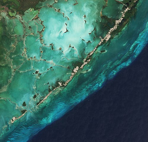
Date: 2019-03-22 Sensor: MSI on Sentinel-2B Resolution: 10m RGB Composites: True color, Band 4-3-2

Date: 2019-02-28 Sensor: MSI on Sentinel-2A Resolution: 10m RGB Composites: True color, Band 4-3-2

Florida Keys by SPOT-5 Satellite

canal to the pier of Key largo harbor in Florida

Jeff Schmaltz, MODIS Rapid Response Team, NASA/GSFC / Public domain

Cemetery in Key West


Malutka wyspa, Florida Keys

wonderful daylight savings time. leave the office at five, on the water from six to eight. Florida Keys.

Iconic watering hole leaving Miami (for good lol) and entering the Florida Keys Lifepixel ir conversion for Canon 50D with Sigma 15 fisheye, full frame equivalent about 25 mm.

Low stress effort, 645 Pro for iphone 6x9 format, Kodachrome ll simulation. No edits, framed only.
Sources
Facts
Photographs
- HDR of Bridge in Florida Keys. EdoDodo / CC BY-SA 3.0
- Florida Keys (from Lower Matecumbe Key to Key Largo) by Sentinel-2. Copernicus Sentinel-2, ESA / CC BY-SA 3.0 igo
- Florida Keys (from Key West to Big Pine Key) by Sentinel-2. Copernicus Sentinel-2, ESA / CC BY-SA 3.0 igo
- Florida Keys SPOT 1283. Cnes - Spot Image / CC BY-SA 3.0
- Key-largo-harbor-3. Elmschrat / CC BY-SA 3.0
- Floridakeys-nasa. Jeff Schmaltz, MODIS Rapid Response Team, NASA/GSFC / Public domain
- Key West cemetery. Daniel Schwen / CC BY-SA 4.0
- 2016-03-27 10-32-37 ILCE-6000 DSC09623 DxO Redo PL4 (50658672221). Miguel Discart from Bruxelles, Belgique / CC BY-SA 2.0
- A small island(js). Jerzystrzelecki / CC BY 3.0
- After work (35055323283). GR from Key Largo / Public domain
- Alabama Jacks (35140921446). GR from Key Largo / Public domain
- Ambiance - Flickr - GR167. GR from Key Largo / Public domain