Dominican Republic
18°48′N 70°12′W
Dominican Republic
Part of Caribbean
The Dominican Republic is an island country on the eastern part of the Caribbean island of Hispaniola in the Greater Antilles of the Caribbean Sea in the North Atlantic Ocean.

Chart
Overview
The Dominican Republic is an island country on the eastern part of the Caribbean island of Hispaniola in the Greater Antilles of the Caribbean Sea in the North Atlantic Ocean. It shares a maritime border with Puerto Rico to the east and a land border with Haiti to the west, occupying the eastern five-eighths of Hispaniola which, along with Saint Martin, is one of only two islands in the Caribbean shared by two sovereign states. In the Antilles, the country is the second-largest by area after Cuba at 48,671 square kilometers (18,792 sq mi) and the second most populous after Haiti with approximately 11.4 million people in 2024, of whom 3.6 million reside in the metropolitan area of Santo Domingo, the capital city. Indigenous peoples had inhabited Hispaniola prior to European contact, including the Taíno, who divided it into five chiefdoms. Christopher Columbus claimed the island for Castile, landing there on his first voyage in 1492. The colony of Santo Domingo became the site of the first permanent European settlement in the Americas. In 1697, Spain recognized French dominion over the western third of the island, which became the independent First Empire of Haiti in 1804. A group of Dominicans deposed the Spanish governor and declared independence from Spain in November 1821, but were annexed by Haiti in February 1822. Independence came 22 years later in 1844, after victory in the Dominican War of Independence. The next 72 years saw several civil wars, corrupt dictatorships, failed invasions by Haiti, and a brief return to Spanish colonial status, before permanently ousting the Spanish during the Dominican Restoration War of 1863–1865. The United States occupied the Dominican Republic from 1916 to 1924, followed by the dictatorship of Rafael Trujillo, ruling from 1930 until his assassination in 1961. Juan Bosch was elected president in 1962 but was deposed in a military coup in 1963. The Dominican Civil War of 1965 preceded a second American occupation and the authoritarian rule of Joaquín Balaguer (1966–1978 and 1986–1996). Since 1996, the Dominican Republic has moved towards representative democracy. The Dominican Republic has the largest economy in the Caribbean and the seventh-largest in Latin America. The country has had the fastest-growing economy in the Western Hemisphere – with an average real GDP growth rate of 5.3% between 1992 and 2018. GDP growth in 2014 and 2015 reached 7.3 and 7.0%, respectively, the highest in the Western Hemisphere. Recent growth has been driven by construction, manufacturing, tourism, and mining. The country is the site of the world's third largest gold mine in terms of production, the Pueblo Viejo mine. The gold production of the country was 31 metric tonnes in 2015. The Dominican Republic is the most visited destination in the Caribbean. A geographically diverse nation, the country is home to both the Caribbean's tallest mountain peak, Pico Duarte, and the Caribbean's largest lake and lowest point, Lake Enriquillo. The island has an average temperature of 26 °C (78.8 °F) and great climatic and biological diversity. The country is also the site of the first cathedral, palace, monastery, and fortress built in the Americas, located in Santo Domingo's Colonial Zone, a World Heritage Site.
From Wikipedia, CC BY-SA 4.0
Census, cataloged
- Major islands1
- Minor islands14
- Islets81
- Rocks & skerries29
Major islands
Hispaniola
- Area
- 73,990 km²
- High point
- 3,098 m
Hispaniola is an island in the Greater Antilles of the Caribbean, located between Cuba and Puerto Rico. It is the most populous island in the West Indies and the second-largest by land area, after Cuba.

Minor islands

Saona Island
- Area
- 108 km²
- High point
- 38 m

Beata Island
- Area
- 41.3 km²
- High point
- 84 m
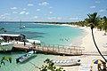
Catalina Island
- Area
- 9 km²
- High point
- 25 m
Isla Alto Velo
- Area
- 0.87 km²
- High point
- 130 m
Cayo Ahogado
- Area
- 0.55 km²
- High point
- 6 m
Unnamed island
- Area
- 0.53 km²
- High point
- 7 m
Cayo Puerto Viejo
- Area
- 0.35 km²
- High point
- 8 m
Unnamed island
- Area
- 0.22 km²
- High point
- 8 m
Cayo Levantado
- Area
- 0.21 km²
- High point
- 33 m
Isla Catalinita
- Area
- 0.17 km²
- High point
- 10 m
Isla Cabras
- Area
- 0.15 km²
- High point
- 12 m
La Piedra
- Area
- 0.14 km²
- High point
- 17 m
Cayo Terrero
- Area
- 0.13 km²
- High point
- 4 m
Cayo Raton
- Area
- 0.1 km²
Islets
- Unnamed island7 m · 0.1 km²
- Unnamed island0.09 km²
- Unnamed island40 m · 0.08 km²
- Cayo Agua Dulce3 m · 0.07 km²
- Unnamed island5 m · 0.07 km²
- Unnamed island48 m · 0.07 km²
- Cayo Ratas3 m · 0.06 km²
- Unnamed island13 m · 0.06 km²
- Unnamed island6 m · 0.06 km²
- Cayo Monte Chico3 m · 0.05 km²
- Unnamed island43 m · 0.04 km²
- Cayo Torurú3 m · 0.04 km²
Rocks & skerries
- Unnamed island<0.1 ha
- Unnamed island<0.1 ha
- Unnamed island<0.1 ha
- Unnamed island<0.1 ha
- Unnamed island<0.1 ha
- Unnamed island<0.1 ha
- Unnamed island<0.1 ha
- Unnamed island<0.1 ha
- Unnamed island<0.1 ha
- Unnamed island<0.1 ha
- Unnamed island<0.1 ha
- Unnamed island<0.1 ha
Figures
Comparative heights
- Hispaniola: 3,098 m
- Isla Alto Velo: 130 m
- Beata: 84 m
- Saona: 38 m
- Cayo Levantado: 33 m
- Catalina: 25 m
- La Piedra: 17 m
- Isla Cabras: 12 m
- Isla Catalinita: 10 m
- Cayo Puerto Viejo: 8 m
- Cayo Vigía: 8 m
- Islote Piedra Negra: 8 m
- Islote Los Frailes: 8 m
- La Matica: 7 m
To the same scale
Islands by area
| Hispaniola | 73,990 km² |
| Saona Island | 108 km² |
| Beata Island | 41.3 km² |
| Catalina Island | 9 km² |
| Isla Alto Velo | 0.87 km² |
| Cayo Ahogado | 0.55 km² |
| Unnamed island | 0.53 km² |
| Cayo Puerto Viejo | 0.35 km² |
| Unnamed island | 0.22 km² |
| Cayo Levantado | 0.21 km² |
| Isla Catalinita | 0.17 km² |
| Isla Cabras | 0.15 km² |
| La Piedra | 0.14 km² |
| Cayo Terrero | 0.13 km² |
| Cayo Raton | 0.1 km² |
| Unnamed island | 0.1 km² |
| Unnamed island | 0.09 km² |
| Unnamed island | 0.08 km² |
| Cayo Agua Dulce | 0.07 km² |
| Unnamed island | 0.07 km² |
| Unnamed island | 0.07 km² |
| Cayo Ratas | 0.06 km² |
| Unnamed island | 0.06 km² |
| Unnamed island | 0.06 km² |
| Cayo Monte Chico | 0.05 km² |
| Unnamed island | 0.04 km² |
| Cayo Torurú | 0.04 km² |
| Cayo Arenas | 0.03 km² |
| Cayo La Farola | 0.03 km² |
| Unnamed island | 0.02 km² |
| Cayo Vigía | 0.02 km² |
| Unnamed island | 0.02 km² |
| Islote Piedra Negra | 0.02 km² |
| Unnamed island | 0.02 km² |
| Unnamed island | 0.02 km² |
| Cayo Muerto | 0.02 km² |
| Unnamed island | 0.02 km² |
| El Jobo | 0.02 km² |
| Cayo Monte Grande | 0.02 km² |
| Unnamed island | 0.02 km² |
| Unnamed island | 0.02 km² |
| La Matica | 0.02 km² |
| Unnamed island | 0.01 km² |
| Unnamed island | 0.01 km² |
| Unnamed island | 0.01 km² |
| Unnamed island | 0.01 km² |
| Unnamed island | 0.01 km² |
| Unnamed island | 0.01 km² |
| Unnamed island | 0.01 km² |
| Unnamed island | 0.01 km² |
| Islote Los Frailes | 0.01 km² |
| Unnamed island | 0.01 km² |
| Unnamed island | 0.9 ha |
| Unnamed island | 0.9 ha |
| Unnamed island | 0.8 ha |
| Unnamed island | 0.7 ha |
| Unnamed island | 0.7 ha |
| Unnamed island | 0.6 ha |
| Unnamed island | 0.5 ha |
| Unnamed island | 0.5 ha |
| Unnamed island | 0.5 ha |
| Unnamed island | 0.5 ha |
| Cayo Puerto Corral | 0.5 ha |
| Unnamed island | 0.4 ha |
| Unnamed island | 0.4 ha |
| Unnamed island | 0.4 ha |
| Cayo Linares | 0.4 ha |
| Unnamed island | 0.4 ha |
| Unnamed island | 0.4 ha |
| Unnamed island | 0.4 ha |
| Unnamed island | 0.3 ha |
| Unnamed island | 0.3 ha |
| Unnamed island | 0.3 ha |
| Unnamed island | 0.3 ha |
| Cayo Puertecito | 0.3 ha |
| Unnamed island | 0.3 ha |
| Unnamed island | 0.3 ha |
| Unnamed island | 0.3 ha |
| Unnamed island | 0.3 ha |
| Unnamed island | 0.3 ha |
| Unnamed island | 0.2 ha |
| Unnamed island | 0.2 ha |
| Unnamed island | 0.2 ha |
| Unnamed island | 0.2 ha |
| Unnamed island | 0.2 ha |
| Unnamed island | 0.2 ha |
| Unnamed island | 0.2 ha |
| Unnamed island | 0.2 ha |
| Unnamed island | 0.1 ha |
| Unnamed island | 0.1 ha |
| Unnamed island | 0.1 ha |
| Unnamed island | 0.1 ha |
| Unnamed island | 0.1 ha |
| Unnamed island | 0.1 ha |
| Unnamed island | 0.1 ha |
| Cayo Zapato | 0.1 ha |
| Unnamed island | <0.1 ha |
| Unnamed island | <0.1 ha |
| Unnamed island | <0.1 ha |
| Unnamed island | <0.1 ha |
| Unnamed island | <0.1 ha |
| Unnamed island | <0.1 ha |
| Unnamed island | <0.1 ha |
| Unnamed island | <0.1 ha |
| Unnamed island | <0.1 ha |
| Unnamed island | <0.1 ha |
| Unnamed island | <0.1 ha |
| Unnamed island | <0.1 ha |
| Unnamed island | <0.1 ha |
| Unnamed island | <0.1 ha |
| Unnamed island | <0.1 ha |
| Unnamed island | <0.1 ha |
| Unnamed island | <0.1 ha |
| Unnamed island | <0.1 ha |
| Unnamed island | <0.1 ha |
| Unnamed island | <0.1 ha |
| Unnamed island | <0.1 ha |
| Unnamed island | <0.1 ha |
| Unnamed island | <0.1 ha |
| Unnamed island | <0.1 ha |
| Unnamed island | <0.1 ha |
| Unnamed island | <0.1 ha |
| Unnamed island | <0.1 ha |
| Unnamed island | <0.1 ha |
| Unnamed island | <0.1 ha |
Overlapping groups
Photographs

Plaza El Tronco

500px provided description: Pasture Road [#red ,#blue ,#brown ,#green ,#dominican republic]

Elias Pina Dominican Republic provinces. Countryside rural town of Rio Limpio.

Elias Pina Dominican Republic provinces. Countryside rural town of Rio Limpio.

The Association of Caribbean States is an organization/alliance in the Caribbean.

Samuel Pereyra Rojas, abogado dominicano, con experiencia en gestión pública y financiera

Miguel Otáñez, presidente de CAESCO

fotografía de la Fuente que se encientra en la casa museo hermanas Mirabal


Outside of Domingo Polonia Stadium

An officer of General Directorate of Traffic and Land Transportation Safety in Dominican Republic
Sources
Facts
Photographs
- Plaza El Tronco. Oleg Yunakov / CC BY-SA 4.0
- Pasture Road (59061468). Will Szal / CC BY-SA 3.0
- Elias Pina Dominican Republic provinces 2. Ultimo1988 / CC BY-SA 4.0
- Elias Pina Dominican Republic provinces 3. Ultimo1988 / CC BY-SA 4.0
- FlagoftheACS. BJBanana / CC BY-SA 4.0
- SPR Samuel Pereyra. Informate dominicana y BellabarbaG / CC0
- Foto oficial de Miguel Otáñez, presidente de CAESCO. Caescord / CC BY-SA 4.0
- Jardin casa museo Hermanas Mirabal. Mauricio Espejo Chura / CC BY-SA 4.0
- Isla Saona banner. Tamas Iklodi w:en:User:It419 / CC BY-SA 3.0
- Drogas.2. Jhonny 40 / CC BY-SA 4.0
- Outside of Domingo Polonia Stadium. JFC1094 / CC0
- An officer of General Directorate of Traffic and Land Transportation Safety in Dominican Republic. Oleg Yunakov / CC BY-SA 4.0