Banda SeaIndonesia
4°35′S 129°55′E
Banda Islands
Kepulauan Banda
Part of Maluku Islands
The Banda Islands (Indonesian: Kepulauan Banda) are a volcanic group of ten small islands in the Banda Sea, about 140 km (87 mi) south of Seram Island and about 2,000 km (1,243 mi) east of Java, and constitute an administrative district (kecamatan) within the Central Maluku Regency in the Indonesian province of Maluku.

Chart
Overview
The Banda Islands (Indonesian: Kepulauan Banda) are a volcanic group of ten small islands in the Banda Sea, about 140 km (87 mi) south of Seram Island and about 2,000 km (1,243 mi) east of Java, and constitute an administrative district (kecamatan) within the Central Maluku Regency in the Indonesian province of Maluku. The islands rise out of 4-to-6-kilometre (2.5 to 3.7 mi) deep ocean and have a total land area of approximately 172 square kilometres (66 sq mi); with associated maritime area this reaches 736.3 square kilometres (284.3 sq mi). They had a population of 18,544 at the 2010 Census and 20,924 at the 2020 Census; the official estimate as of mid-2023 was 21,902. Until the mid-19th century the Banda Islands were the world's only source of the spices nutmeg and mace, produced from the nutmeg tree. The islands are also popular destinations for scuba diving and snorkeling. The main town and administrative centre is Banda Neira, located on the island of the same name.
From Wikipedia, CC BY-SA 4.0
Census, cataloged
- Major islands4
- Minor islands3
- Islets3
- Rocks & skerries0
Major islands
Banda Besar
- Area
- 25.4 km²
- High point
- 521 m
Banda Besar (English pronunciation: ; 'Great Banda', Dutch: Groot-Banda), also known historically as Lonthoir (alternatively spelt Lonthor or Lontor), is the largest of the Banda Islands in Indonesia. It is administered as part of Banda District, Central Maluku Regency, Maluku Province.
Gunungapi Island
- Area
- 7.3 km²
- High point
- 640 m
Banda Api (Indonesian api, fire) is an island in the Banda Islands, Indonesia. It is administered as part of the administrative district (kecamatan) within the Central Maluku Regency in the province of Maluku.
Rhun Island
- Area
- 3.7 km²
- High point
- 174 m
Run (also known as Pulau Run, Pulo Run, Puloroon, Polo or Rhun – pulau is 'island' in Indonesian) is one of the smallest islands of the Banda Islands, which are a part of the Moluccas, Indonesia. It is located within Banda District (kecamatan) in Central Maluku Regency.
Neira Island
- Area
- 3.4 km²
- High point
- 243 m
Banda Neira (or Pulau Neira) is an island in the Banda Islands, Indonesia. It is administered as part of the administrative Banda Islands District (Kecamatan Kepulauan Banda) within the Central Maluku Regency in the province of Maluku.

Minor islands
Hatta Island
- Area
- 4.3 km²
- High point
- 173 m
Ay Island
- Area
- 3.5 km²
- High point
- 123 m
Syahrir Island
- Area
- 0.2 km²
- High point
- 53 m
Islets
- Nailaka Island7 m · 0.04 km²
- Karaka Island13 m · 0.02 km²
- Batu Kapal Island0.2 ha
Figures
Comparative heights
To the same scale
Islands by area
| Banda Besar | 25.4 km² |
| Gunungapi Island | 7.3 km² |
| Hatta Island | 4.3 km² |
| Rhun Island | 3.7 km² |
| Ay Island | 3.5 km² |
| Neira Island | 3.4 km² |
| Syahrir Island | 0.2 km² |
| Nailaka Island | 0.04 km² |
| Karaka Island | 0.02 km² |
| Batu Kapal Island | 0.2 ha |
Photographs

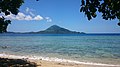
View from Pulau Pisang

The town of Banda Neira viewed from Gunung Api in the Banda Islands, Maluku, Indonesia

Pulau Run view from hilltop (2015)

BandaVolcano

An Indonesian island of Banda Besar seen from Fort Belgica.

NASA/METI/AIST/Japan Space Systems, and U.S./Japan ASTER Science Team / Public domain

Banda harbor, Kami Memperkenalkan Maluku dan Irian Barat, p11
Sources
Facts
Photographs
- Banda Pisang. WiDi / CC BY-SA 4.0
- Bandaneira-0039. Anton Leddin / CC BY-SA 3.0
- Pulau Run. L.bazoeira / CC BY-SA 4.0
- BandaVolcano. User Mark Richards on en.wikipedia / CC BY-SA 3.0
- BandaBesarIslandSeenFromFortBelgica. Photo by Mark Richards / CC BY-SA 3.0
- Run Island, Indonesia (ASTER). NASA/METI/AIST/Japan Space Systems, and U.S./Japan ASTER Science Team / Public domain
- Banda harbor, Kami Memperkenalkan Maluku dan Irian Barat, p11. Uncredited. / Public domain
- Pisang Banner. WiDi / CC BY-SA 4.0
- Banda banner. WiDi / CC BY-SA 4.0