Indonesia
8°15′S 124°45′E
Alor Archipelago
Kepulauan Alor
Part of Lesser Sunda Islands
The Alor Archipelago (Indonesian: Kepulauan Alor; Indonesian pronunciation: [kəpuˌlawan ˈalɔr]) is part of Indonesia and is located in the eastern part of Lesser Sunda Islands.

Chart
Overview
The Alor Archipelago (Indonesian: Kepulauan Alor; Indonesian pronunciation: [kəpuˌlawan ˈalɔr]) is part of Indonesia and is located in the eastern part of Lesser Sunda Islands. The indigenous people of the Alor Archipelago are a collection of ethnic groups with dominant Papuan gene descent of up to 90% with a 10% Austronesian mixture. The native languages of Alor are a Papuan languages from the Alor–Pantar branch, with the only native Austronesian language of Alor being Alorese. Alor is the largest island in the archipelago which is located at its eastern end. Pantar is the second-largest island in the archipelago, situated between Alor and Lembata. Smaller islands in the group include Pura, Buaya, Ternate (not to be confused with Ternate in the North Moluccas), and Tereweng, all situated in the Pantar Strait between the two main islands, and Kangge, Rusa, and Kambing off the west coast of Pantar in the Alor Strait, and a small island north of Alor, Sika. Administratively, the Alor archipelago forms its own regency (Indonesian: kabupaten) within the province of East Nusa Tenggara. The Regency is divided into seventeen districts and 158 villages, and has an area of 2,928.88 km2 and a population at the 2020 Census of 211,872; the official estimate as at mid 2022 was 216,626.
To the east of the archipelago is the Ombai Strait, which separates it from the islands of Wetar and Atauro, the latter belonging to East Timor. To the south, across the Savu Sea, lies the western part of Timor. To the north lies the Banda Sea. To the west lies Lembata and then the rest of the Sunda Islands.
From Wikipedia, CC BY-SA 4.0
Census, cataloged
- Major islands2
- Minor islands12
- Islets6
- Rocks & skerries2
Major islands
Alor Island
- Area
- 2,114 km²
- High point
- 1,821 m
Alor (Indonesian: Pulau Alor) is the largest island in the Alor Archipelago and is one of the 92 officially listed outlying islands of Indonesia.
Pantar
- Area
- 730 km²
- High point
- 1,336 m
Pantar (Indonesian: Pulau Pantar; Indonesian pronunciation: [ˌpulau̯ ˈpan̪t̪ar]) is the second largest island in the Indonesian Alor Archipelago, after Alor. To the east is the island of Alor and other small islands in the archipelago; to the west is the Alor Strait, which separates it from the Solor Archipelago.

Minor islands
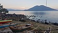
Pura Island
- Area
- 27.7 km²
- High point
- 1,015 m

Kangge Island
- Area
- 13.8 km²
- High point
- 187 m
Rusa Island
- Area
- 13.6 km²
- High point
- 330 m
Ternate Island
- Area
- 3.8 km²
- High point
- 432 m
Treweng Island
- Area
- 3.7 km²
- High point
- 373 m
Batang Island
- Area
- 3.5 km²
- High point
- 246 m
Lapang Island
- Area
- 2.4 km²
- High point
- 15 m
Pulau Buaya
- Area
- 2.1 km²
- High point
- 92 m
Kambing Island
- Area
- 2 km²
- High point
- 92 m
Sika Island
- Area
- 0.51 km²
- High point
- 13 m
Kura Island
- Area
- 0.51 km²
- High point
- 18 m
Kepa Island
- Area
- 0.48 km²
- High point
- 68 m
Islets
- Pulau Kapas5 m · 0.06 km²
- Unnamed island16 m · 0.02 km²
- Unnamed island0.5 ha
- Unnamed island5 m · 0.3 ha
- Unnamed island2 m · 0.3 ha
- Unnamed island7 m · 0.2 ha
Rocks & skerries
- Nub Island<0.1 ha
- Unnamed island<0.1 ha
Figures
Comparative heights
To the same scale
Islands by area
| Alor Island | 2,114 km² |
| Pantar | 730 km² |
| Pura Island | 27.7 km² |
| Kangge Island | 13.8 km² |
| Rusa Island | 13.6 km² |
| Ternate Island | 3.8 km² |
| Treweng Island | 3.7 km² |
| Batang Island | 3.5 km² |
| Lapang Island | 2.4 km² |
| Pulau Buaya | 2.1 km² |
| Kambing Island | 2 km² |
| Sika Island | 0.51 km² |
| Kura Island | 0.51 km² |
| Kepa Island | 0.48 km² |
| Pulau Kapas | 0.06 km² |
| Unnamed island | 0.02 km² |
| Unnamed island | 0.5 ha |
| Unnamed island | 0.3 ha |
| Unnamed island | 0.3 ha |
| Unnamed island | 0.2 ha |
| Nub Island | <0.1 ha |
| Unnamed island | <0.1 ha |
Photographs

Kangge island, next to Pantar island, Alor Archipelago, Indonesia. Aerial view.

Beautiful view and clear sky from Pura Island - Alor - East Nusa Tenggara

Sources
Facts
Photographs
- Beautiful view from Pura Island - Alor - East Nusa Tenggara. Sims8899 / CC BY-SA 4.0
- Kangge island, next to Pantar island, Alor Archipelago, Indonesia. Marek Ślusarczyk (Tupungato) Photo gallery / CC BY 3.0
- East Timor Satellite. Unknown author / Public domain
- WV banner Alor Islands coastline. U.S. Navy photo by Photographer's Mate 3rd Class Rebecca J. Moat / Public domain