Lipari Island
Isola di Lipari
38°29′N 14°56′E
Lipari ( LIP-ər-ee, Italian: [ˈliːpari]; Sicilian: Lìpari; Latin: Lipara or Meligūnis; Ancient Greek: Μελιγουνίς, romanized: Meligounís, or Λιπάρα, Lipára) is the largest of the seven Aeolian Islands, located in the Tyrrhenian Sea off the northern coast of the Sicily in southern Italy, and a comune (municipality) including six of them (Lipari, Vulcano, Panarea, Stromboli, Filicudi and Alicudi); it is administratively part of Metropolitan City of Messina.

Terrain
38°29′N 14°56′E
Overview
Lipari ( LIP-ər-ee, Italian: [ˈliːpari]; Sicilian: Lìpari; Latin: Lipara or Meligūnis; Ancient Greek: Μελιγουνίς, romanized: Meligounís, or Λιπάρα, Lipára) is the largest of the seven Aeolian Islands, located in the Tyrrhenian Sea off the northern coast of the Sicily in southern Italy, and a comune (municipality) including six of them (Lipari, Vulcano, Panarea, Stromboli, Filicudi and Alicudi); it is administratively part of Metropolitan City of Messina. It has 12,794 permanent residents, but during the May to September tourist season, the total population may reach up to 20,000. It is also the name of the biggest island in the archipelago, where the main urban area of the municipality is located.
From Wikipedia, CC BY-SA 4.0
Chart
Nearest islands
Also in Aeolian Islands


Photographs
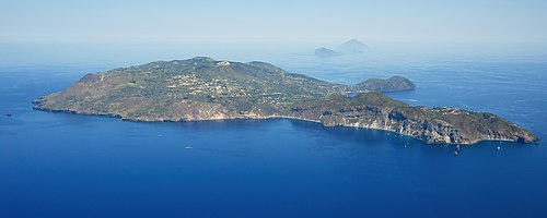
Aerial image of Lipari (view from the southwest)

Blick vom Monte San Angelo nach Lipari-Stadt. Eine Fähre der N.G.I. nähert sich dem großen Hafen (Marina Lunga). Rechts von der Mitte der Burgberg mit der Kathedrale und dem Rathaus. Dahinter der kleine Hafen (Marina Corta)

Isola di Lipari (Q55389037)

Kleiner, noch gelegentlich genutzter Steinbruch östlich von Castellaro bzw. nördlich des Monte San Angelo, Lipari

Die "neue" Kirche in Quattropani, Lipari. Chiesa di Maria Santissima della Purità.

Landschaftseindruck von West-Lipari. Der Timpone Ricotta in der Bildmitte

Erosionsformen in unterschiedlich harten Bimslagen, darauf bodenbedingte "Halbwüste"

Die Regenwasser-Sammelanlage am Monte San Angelo auf Lipari.

Blick vom Bereich um den Monte San Angelo nach Süden. Links Lipari (Stadt), in der Mitte der Monte Guardia, im Hintergrund Vulcano

Blick von Nordosten zum Monte Chirica, höchste Erhebung von Lipari (602m)

Blick vom Bereich um den Monte San Angelo hinunter zum Monte Rosa, dem Doppelberg am Ostzipfel von Lipari

A journey to the Aeolian islands.
Sources
Facts
Photographs
- Aerial image of Lipari (view from the southwest). Carsten Steger / CC BY-SA 4.0
- Lipari Draufsicht. GerritR / CC BY-SA 4.0
- Lipari maggio 2022 17. ZioAngelo / CC BY-SA 4.0
- Bims-Steinbruch auf Lipari. GerritR / CC BY-SA 4.0
- Chiesa Nuova Quattropani. GerritR / CC BY-SA 4.0
- Lipari Landschaft West. GerritR / CC BY-SA 4.0
- Bimserosion südlich Monte Chirica, Lipari. GerritR / CC BY-SA 4.0
- Lipari Regenwassersammelanlage Monte San Angelo. GerritR / CC BY-SA 4.0
- Lipari Süd. GerritR / CC BY-SA 4.0
- Monte Chirica. GerritR / CC BY-SA 4.0
- Monte Rosa, Lipari. GerritR / CC BY-SA 4.0
- Aeolian Islands (8). stefan_fotos from Leipzig, Germany / CC BY-SA 2.0