Ko Samui
เกาะสมุย
9°30′N 100°00′E
Ko Samui or Koh Samui, often locally shortened to Samui, is an island off the east coast of Thailand. Geographically in the Chumphon Archipelago, it is part of Surat Thani Province, though as of 2012, Ko Samui was granted municipal status and thus is now locally self-governing.

Terrain
9°30′N 100°00′E
Overview
Ko Samui or Koh Samui, often locally shortened to Samui, is an island off the east coast of Thailand. Geographically in the Chumphon Archipelago, it is part of Surat Thani Province, though as of 2012, Ko Samui was granted municipal status and thus is now locally self-governing. Ko Samui, with an area of 228.7 square kilometres (88.3 sq mi), is Thailand's second largest island after Phuket. In 2018, it was visited by 2.7 million tourists.
From Wikipedia, CC BY-SA 4.0
Chart
Nearest islands
- Ko Taen17 km
- Koh Tae Nai23 km
- Ko Tae Nok23 km
- Ko Pha-ngan27 km
- Ko Phaluai34 km
- Ko Tao67 km
Also in Samui

Ko Pha-ngan
122 km²▲ 627 m
Major islands

Ko Tao
18.4 km²▲ 375 m
Minor islands

Ko Phaluai
15.8 km²▲ 343 m
Minor islands

Ko Taen
6.8 km²▲ 215 m
Minor islands
Ko Tae Nok
0.24 km²▲ 82 m
Minor islands
Koh Tae Nai
0.17 km²▲ 77 m
Minor islands
Photographs

Ko Samui, Thailand
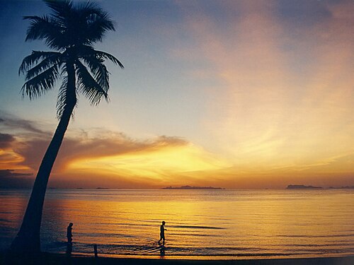
Lipa Noi Beach on Ko Samui, Thailand, shortly after sunset with coco palm. The islands of the Ang Thong Marine National Park (Mu Koh Angthong) are visible at the horizon.

Miskawaan Acacia

Miskawaan Pool View

Koh Samui, 09.04.2013

Night at Chaweng, Samui 2014, february

Koh Samui Thailand

Night at Chaweng, Samui 2014, february

Night at Samui 2014, february

Night at Samui ChawengNoi (2014 febr.)

Night at Samui ChawengNoi (2014 febr.)

Samui (2014 febr.)
Sources
Facts
Photographs
- Ko Samui, Thailand (Unsplash FgiVhlKhOCc). Anthony DELANOIX anthonydelanoix / CC0
- Koh Samui Lipa Noi2. Manfred Werner / CC BY-SA 3.0
- Miskawaan Acacia. Miskawaan Co Ltd. / CC BY-SA 3.0
- Miskawaan Pool View. Miskawaan / CC BY-SA 3.0
- 2013 04 09 Koh Samui (10). Joachim Lutz / CC BY-SA 4.0
- Night at Chaweng, Samui 2014, february - panoramio (1). Roma Neus / CC BY 3.0
- Koh Samui Thailand (7663148434). cloud.shepherd / CC BY 2.0
- Night at Chaweng, Samui 2014, february - panoramio. Roma Neus / CC BY 3.0
- Night at Samui 2014, february - panoramio. Roma Neus / CC BY 3.0
- Night at Samui ChawengNoi (2014 febr.) - panoramio (1). Roma Neus / CC BY 3.0
- Night at Samui ChawengNoi (2014 febr.) - panoramio (2). Roma Neus / CC BY 3.0
- Samui (2014 febr.) - panoramio (12). Roma Neus / CC BY 3.0