Fairway Rock
Roca Fairway, Fairwayklippan
65°38′N 168°45′W
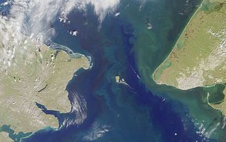
Fairway Rock (Inupiaq: Ugiiyaq) (Census block 1047, Nome, Alaska) is a small islet with mostly vertical rock faces in the Bering Strait, located southeast of the Diomede Islands and west of Alaska's Cape Prince of Wales. S. 12 mi2).

Terrain
65°38′N 168°45′W
Overview
Fairway Rock (Inupiaq: Ugiiyaq) (Census block 1047, Nome, Alaska) is a small islet with mostly vertical rock faces in the Bering Strait, located southeast of the Diomede Islands and west of Alaska's Cape Prince of Wales. Part of Alaska, a U.S. state, the islet has an area of 0.3 km2 (0.12 mi2). Known to Inuit of the Bering Strait region in prehistory, Fairway was documented by James Cook in 1778 and named by Frederick Beechey in 1826. Although uninhabited, the island is a nesting site for seabirds — most notably the least and crested auklet — which prompt egg-collecting visits from local indigenous peoples. The United States Navy placed radioisotope thermoelectric generator-powered environmental monitoring equipment on the island from the 1960s through the 1990s.
From Wikipedia, CC BY-SA 4.0
Chart
Nearest islands
- Little Diomede Island16 km
- Big Diomede Island23 km
Also in Diomede Islands

Big Diomede Island
29.2 km²▲ 505 m
Major islands
Little Diomede Island
6.3 km²▲ 494 m
Major islands
Photographs

Fairway Rock (Bering Strait, Alaska, USA; 65°37‘26‘‘N, 168°44‘23‘‘W)

Vintage photo fairway rock bering strait

View of Fairway Rock in the Bering Sea, as seen through the periscope of the U.S. Navy submarine USS Nautilus (SSN-571), proceeding to the North Pole, 12 August 1958.

Sources
Facts
Photographs
- Fairway Rock 1 2014-08-17. Ansgar Walk / CC BY-SA 3.0
- Vintage photo fairway rock bering strait. U.S. Fish and Wildlife Service / Public domain
- View of Fairway Rock in the Bering Sea, 12 August 1958 (USN 1037069). Unknown authorUnknown author / Public domain
- FMIB 45403 Diomedes. Henry Wood Elliott / Public domain