Bikini Atoll
Bikini
11°38′N 165°33′E
Bikini Atoll ( BIK-in-ee or bih-KEE-nee; Marshallese: Pikinni [pʲiɡinnʲi], lit. 1 km2) central lagoon. The atoll is at the northern end of the Ralik Chain, approximately 530 miles (850 km) northwest of the capital Majuro.

Terrain
11°38′N 165°33′E
Overview
Bikini Atoll ( BIK-in-ee or bih-KEE-nee; Marshallese: Pikinni [pʲiɡinnʲi], lit. 'Coconut place'), known as Eschscholtz Atoll between the 19th century and 1946, is a coral reef in the Marshall Islands consisting of 23 islands surrounding a 229.4-square-mile (594.1 km2) central lagoon. The atoll is at the northern end of the Ralik Chain, approximately 530 miles (850 km) northwest of the capital Majuro. After the Second World War, the atoll was chosen by the United States as a nuclear weapon testing site. The 167 people who lived on Bikini were forcefully relocated by the U.S. military in preparation for testing. In 1946, the Bikini population moved to Rongerik, a small island east of Bikini Atoll, but it did not have adequate resources to support them. The islanders began experiencing starvation by early 1948, and were moved to Kwajalein Atoll. The U.S. used Bikini Atoll for the fourth detonation of a nuclear bomb, and carried out 22–23 additional nuclear tests there until 1958, when it was discovered that the fallout from testing was much more dangerous than previously thought. To this day, the Bikini islanders are prohibited from returning to Bikini Atoll due to nuclear contamination. However, there are some signs of recovery as the amount of radiation slowly decreases. In 1972, about 100 residents were voluntarily returned to their home island. Scientists later found dangerously high levels of strontium-90 in well water in May 1978, and the residents' bodies were carrying abnormally high concentrations of caesium-137. They were evacuated again in September 1978. The atoll is occasionally visited today by divers and a few scientists, and it is occupied by a handful of caretakers. The people of the atoll, which now number in the thousands, have spread out to other Marshallese islands and the United States. A multi-million dollar trust fund, which had been supporting services for many Bikini inhabitants since the 1980s, was drained in the late 2010s. In the 21st century, the atoll is a World Heritage Site, remembered for its role in the Cold War and the post-nuclear age. It is noted as an enclave of nature, and the radiation has decreased enough that tourism is possible. However, the lingering radioactive contamination makes it unfit to return to from what was expected to be short-term evacuation, especially as it is not recommended to eat plants or wildlife.
From Wikipedia, CC BY-SA 4.0
Chart
Nearest islands
Also in Bikini Islands
Also in Ralik Chain
Ailinglaplap Atoll
14.7 km²▲ 3 m
Major islands
Jaluit Atoll
11.3 km²▲ 3 m
Major islands
Namu Atoll
6.3 km²▲ 3 m
Major islands
Enewetak Atoll
5.9 km²▲ 5 m
Major islands
Ebon Atoll
5.8 km²▲ 25 m
Major islands
Wotho Atoll
4.3 km²▲ 3 m
Major islands
Jabor
3.4 km²▲ 21 m
Major islands

Kwajalein Atoll
3.1 km²▲ 18 m
Major islands
Also in Marshall Islands
Bokak Atoll
81.3 km²▲ 3 m
Major islands
Mili Atoll
14.9 km²▲ 3 m
Major islands
Ailinglaplap Atoll
14.7 km²▲ 3 m
Major islands
Arno Atoll
13 km²▲ 3 m
Major islands
Jaluit Atoll
11.3 km²▲ 3 m
Major islands
Likiep Atoll
10.3 km²▲ 10 m
Major islands
Maloelap Atoll
9.8 km²▲ 3 m
Major islands
Rairik
8.3 km²▲ 20 m
Major islands
Also in Micronesia
Federated States of Micronesia
702 km²
Major islands
Tabukaokao
586 km²▲ 10 m
Major islands

Kiritimati
546 km²▲ 13 m
Major islands

Guam
543 km²▲ 406 m
Major islands
Palau
466 km²
Major islands

Saipan
119 km²▲ 474 m
Major islands

Tinian
101 km²▲ 181 m
Major islands
Abanekeneke
99.9 km²▲ 21 m
Major islands
Photographs

Scientists check the condition of the Bikini islands six years after the last nuclear test took place there.

Bikini Atoll

Bikini Atoll Nuclear Test Site (Marshall Islands)
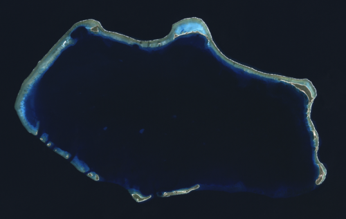
Composite "true color" multispectral satellite image of Bikini Atoll, Marshall Islands. NASA Landsat 7 ETM+ bands used were 3 (red), 2 (green) and 1 (blue), and the image was pan-sharpened to 15m resolution. Imagery courtesy of NASA/USGS.

Bikini Atoll Nuclear Test Site (Marshall Islands)

Scientists check the condition of the Bikini islands six years after last nuclear testing took place there.

A device tested in Operation Castle being moved by truck.

Members of the Seabees' 53rd Naval Construction Battalion build camera towers prior to atomic bomb testing on Bikini Atoll, July 1946.

An unknown device tested in Operation Castle. The device may be Morgenstern (Castle Koon).


The atomic cloud during the "Baker" nuclear test at the Bikini atoll.

The atomic cloud during the "Baker" nuclear test at the Bikini atoll.
Sources
Facts
Photographs
- HD.10.020 (10561377523). ENERGY.GOV / Public domain
- BikiniAtoll. Fashionby He / CC BY 2.0
- Bikini Atoll Nuclear Test Site-115009. Ron Van Oers / CC BY-SA 3.0 igo
- Bikini Atoll 2001-01-14, Landsat 7 ETM+, bands 3-2-1-8. NASA / Public domain
- Bikini Atoll Nuclear Test Site-115011. Ron Van Oers / CC BY-SA 3.0 igo
- HD.10.019 (10561376293). ENERGY.GOV / Public domain
- Operation Castle AW 2. United States Atomic Energy Agency / Public domain
- Seabees build camera tower on Bikini Atoll. Uninown / Public domain
- Operation Castle AW 5. United States Atomic Energy Agency / Public domain
- Bikini Atoll 2001-01-14, Landsat 7 ETM+ bands 7-5-1-8. NASA / Public domain
- Baker nucelar test at Bikini atoll 1946. U.S. Navy (photo 80-G-396229) / Public domain
- Baker nuclear test blast at Bikini atoll 1946. U.S. Navy (photo 80-G-396231) / Public domain