Beaufort Island
螺洲 Beaufort Island
22°11′N 114°15′E
Beaufort Island is a member of the Po Toi group of islands in Hong Kong. Its size is about 120 ha (300 acres) while its highest point is 270 m (890 ft) above sea level.

Terrain
22°11′N 114°15′E
Overview
Beaufort Island is a member of the Po Toi group of islands in Hong Kong. Its size is about 120 ha (300 acres) while its highest point is 270 m (890 ft) above sea level. The channel next to Beaufort Island called Lo Chau Mun, or Beaufort Channel, is the deepest part of Hong Kong at 66 m (217 ft) below sea level.
From Wikipedia, CC BY-SA 4.0
Chart
Nearest islands
- Po Toi2.0 km
- Sung Kong3.5 km
- Round Island7.7 km
- Tung Lung Chau8.1 km
- Hong Kong Island8.2 km
- Middle Island8.9 km
Also in Po Toi Islands

Also in Tau Chau
Hong Kong Island
78.6 km²▲ 552 m
Minor islands
Lamma Island
13.9 km²▲ 353 m
Minor islands

Po Toi
3.7 km²▲ 242 m
Minor islands
Tung Lung Chau
2.4 km²▲ 250 m
Minor islands
Ap Lei Chau
1.4 km²▲ 196 m
Minor islands
Middle Island
0.24 km²▲ 119 m
Minor islands
Round Island
0.14 km²▲ 72 m
Minor islands
Photographs

Aerial view of Waglan Island, Sung Kong (宋崗) and Lo Chau (螺洲, Beaufort Island) could be seen in the background on the left off the shore of Hong Kong Island.

Aerial view of Waglan Island, Sung Kong, Lo Chau and Po Toi Island of Po Toi Islands off the Southeastern coast of Hong Kong Island

Lo Chau (螺洲, Beaufort Island) in Po Toi Islands

Beaufort Island Hong Kong and Lo Chau Mun (Channel between Po Toi Island and Beaufort Island and the deepest ocean part in Hong Kong)

Ng Fan Chau in Shek O

View from Observation Post of Bokhara Battery
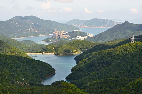
HK Island South Tai Tam Tuk Reservoir

Po Toi Tai Wan and Beaufort Island

Tai Tam, Hong Kong

View over Stanley and Stanley Bay, with islands of the w:Wanshan Archipelago in the distance from the #260 bus traveling up Stanley Gap Road. Po Toi Islands are visible on the left

Sources
Facts
Photographs
- Waglan Island Sung Kong Lo Chau. Geographer / CC BY-SA 3.0
- Po Toi Islands Aerial . Geographer / CC BY-SA 3.0
- Lo Chau Po Toi Islands. Geographer / CC BY-SA 3.0
- Beaufort Island Hong Kong. Nhk9 / CC BY-SA 4.0
- 石澳 Shek O 五分洲 Ng Fan Chau, 2021. Lord Jaraxxus / CC BY-SA 4.0
- View from Bokhara Battery ph3. Starcopter / CC BY-SA 4.0
- Tai Tam Tuk Reservoir. Je.T. from Hong Kong, Hong Kong / CC BY-SA 2.0
- Po Toi Tai Wan and Beaufort Island. Millevache / CC BY-SA 3.0
- Tai Tam, Hong Kong - panoramio. seppotuomas / CC BY-SA 3.0
- Stanley and Stanley Bay, Hong Kong. Daniel Case / CC BY-SA 3.0
- Stanley Peninsula. Unknown author / CC BY-SA 3.0