Singapore
1°14′N 103°51′E
Southern Islands
The Southern Islands is a planning area consisting of a collection of islets located within the Central Region of Singapore, once home to the native Malay islanders and indigenous Orang Laut sea nomad tribes before they were relocated to the mainland for urban redevelopment and future use.

Chart
Overview
The Southern Islands is a planning area consisting of a collection of islets located within the Central Region of Singapore, once home to the native Malay islanders and indigenous Orang Laut sea nomad tribes before they were relocated to the mainland for urban redevelopment and future use. The islands that form the planning area are Kusu Island, Lazarus Island, Pulau Seringat, Pulau Tekukor, Saint John's Island, Sentosa and the two Sisters' Islands. The islands encompass a total land area of about 5.58 square kilometres (2.15 sq mi). The Sentosa Development Corporation oversaw the development and maintenance of these offshore islands south of Singapore from 1976 to March 2017, when it handed it back to the Singapore Land Authority. The Southern Islands planning area is situated on the Singapore Straits, south of the mainland planning area of Bukit Merah. It also shares maritime boundary with the Western Islands planning area. The planning area has two subzones: Sentosa and the Southern Group, the latter of which includes all the major islands except Sentosa.
From Wikipedia, CC BY-SA 4.0
Census, cataloged
- Major islands2
- Minor islands3
- Islets7
- Rocks & skerries9
Major islands
Sentosa
- Area
- 4.9 km²
- High point
- 90 m
Sentosa Island, known mononymously as Sentosa, is an island located off the southern coast of Singapore's main island. The island is separated from the main island of Singapore by a channel of water, the Keppel Harbour, and is adjacent to Pulau Brani, a smaller island wedged between Sentosa and the main island.
Saint John's Island
- Area
- 0.42 km²
- High point
- 48 m
5 km off the southern coast of Singapore. 16 sq mi), it is the largest of the Marine Park islands which also include the Sisters' Islands and Pulau Tekukor. St John's was colonised by the British along with mainland Singapore in the 19th century and was the site of a colonial quarantine centre.


Minor islands
Lazarus Island
- Area
- 0.4 km²
- High point
- 55 m

Pulau Seringat
- Area
- 0.31 km²
- High point
- 17 m
Pulau Seringat Kecil
- Area
- —
size unknown
Islets
- Kusu Island32 m · 0.08 km²
- Big Sisters' Island22 m · 0.05 km²
- Pulau Tekukor25 m · 0.05 km²
- Kias Island5 m · 0.04 km²
- Little Sisters' Island25 m · 0.03 km²
- Unnamed island2 m · 0.5 ha
- Unnamed island0.1 ha
Rocks & skerries
- Unnamed island<0.1 ha
- Unnamed island<0.1 ha
- Unnamed island<0.1 ha
- Unnamed island<0.1 ha
- Unnamed island<0.1 ha
- Unnamed island<0.1 ha
- Unnamed island<0.1 ha
- Unnamed island<0.1 ha
- Unnamed island<0.1 ha
Figures
Comparative heights
- Sentosa: 90 m
- Lazarus: 55 m
- Saint John's: 48 m
- Kusu: 32 m
- Pulau Tekukor: 25 m
- Little Sisters': 25 m
- Big Sisters': 22 m
- Pulau Seringat: 17 m
- Kias: 5 m
To the same scale
Islands by area
| Sentosa | 4.9 km² |
| Saint John's Island | 0.42 km² |
| Lazarus Island | 0.4 km² |
| Pulau Seringat | 0.31 km² |
| Kusu Island | 0.08 km² |
| Big Sisters' Island | 0.05 km² |
| Pulau Tekukor | 0.05 km² |
| Kias Island | 0.04 km² |
| Little Sisters' Island | 0.03 km² |
| Unnamed island | 0.5 ha |
| Unnamed island | 0.1 ha |
| Unnamed island | <0.1 ha |
| Unnamed island | <0.1 ha |
| Unnamed island | <0.1 ha |
| Unnamed island | <0.1 ha |
| Unnamed island | <0.1 ha |
| Unnamed island | <0.1 ha |
| Unnamed island | <0.1 ha |
| Unnamed island | <0.1 ha |
| Unnamed island | <0.1 ha |
Photographs

Beach Island Singapore

Northeast beach on Saint John’s Island, Singapor

An aerial view of Sentosa, Singapore, as seen from the Carlsberg Sky Tower (now known as the Tiger Sky Tower).

one of a many photos I took over the past years

Beach Island Singapore

Nature

Southern Islands, Singapore

Southern Islands, Singapore

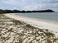
Lazarus Island Beach in April of 2023

Near the causeway to Lazarus Island View Point (2023)

St John's Island - Lazarus Causeway in 2023

St John's Island Pier in 2023
Sources
Facts
Photographs
- Beach Island Singapore - panoramio. Chanilim714 / CC BY-SA 3.0
- Saint John's Island (Singapore) SF0001. Stefan Fussan / CC BY-SA 4.0
- Sentosa viewed from the Carlsberg Sky Tower, Singapore - 20060716-03. Terence Ong at the English Wikipedia. / CC BY 2.5
- My recent photos7. Wishds / CC BY-SA 4.0
- Beach Island Singapore - panoramio - Chanilim714. Chanilim714 / CC BY-SA 3.0
- Nature - panoramio (1). Айрат Хайруллин / CC BY 3.0
- Southern Islands, Singapore - panoramio (18). Mezanur Rahman / CC BY 3.0
- Southern Islands, Singapore - panoramio (20). Mezanur Rahman / CC BY 3.0
- Lazarus Island Beach (2023). Deoma12 / CC BY 4.0
- Lazarus Island View Point (2023). Deoma12 / CC BY 4.0
- St John's Island - Lazarus Causeway in 2023. Deoma12 / CC BY 4.0
- St John's Island Pier in 2023. Deoma12 / CC BY 4.0