Celebes SeaIndonesia
3°00′N 125°30′E
Sangihe Islands
Kepulauan Sangihe
Part of Greater Sunda Islands
The Sangihe Islands (also spelled "Sangir", "Sanghir" or "Sangi") – Indonesian: Kepulauan Sangihe – are a group of islands that constitute two regencies within the province of North Sulawesi, in northern Indonesia, the Sangihe Islands Regency (Kabupaten Kepulauan Sangihe) and the Sitaro Islands Regency (Kabupaten Siau Tagulandang Biaro).

Chart
Overview
The Sangihe Islands (also spelled "Sangir", "Sanghir" or "Sangi") – Indonesian: Kepulauan Sangihe – are a group of islands that constitute two regencies within the province of North Sulawesi, in northern Indonesia, the Sangihe Islands Regency (Kabupaten Kepulauan Sangihe) and the Sitaro Islands Regency (Kabupaten Siau Tagulandang Biaro). They are located northeast of Sulawesi between the Celebes Sea and the Molucca Sea, roughly halfway between Sulawesi and Mindanao, in the Philippines; the Sangihes form the eastern limit of the Celebes Sea. The islands combine to total 813 square kilometers (314 sq mi), with many of the islands being actively volcanic with fertile soil and mountains. The main islands of the group are, north to south, Sangir Besar (or Sangir Island), Siau (or Siao), Tagulandang, and Biaro. The largest island is Sangir Besar and contains an active volcano, Mount Awu (1,320 meters (4,330 ft)). Tahuna is the chief town and port, also hosting the islands' sole airport, Naha Airport. The area came under Dutch control in 1677 and became part of Indonesia when it declared independence from the Netherlands in 1945. The Sangir language is spoken in the islands; this Austronesian language is also spoken in some islands in the Philippines, and on the extreme northern tip of Sulawesi. The Sangihe tectonic plate is named after the island arc and is very active. On 2 January 2007, the Sitaro Islands (named for Siau, Tagulandang, and Biaro Islands) became a new regency by separation from the Sangihe Islands. The population for these island groups was 189,676 at the 2010 Census, comprising 126,133 in the Sangihe Islands Regency and 63,543 in the Sitaro Islands Regency; the official estimate as of mid-2022 was 212,682, comprising 140,165 in the Sangihe Islands Regency and 72,517 in the Sitaro Islands Regency.
From Wikipedia, CC BY-SA 4.0
Census, cataloged
- Major islands2
- Minor islands29
- Islets70
- Rocks & skerries109
Major islands
Sangihe Island
- Area
- 550 km²
- High point
- 1,320 m
Sangir Besar, commonly called Sangir Island (with the spelling variants "Sangihe", "Sanghir" or "Sangi"), is an island in the Sangir Islands group. Its Indonesian name literally means "Great Sangir", in reference to the fact that it is the archipelago's main island. It is part of the North Sulawesi province.
Siau Island
- Area
- 114 km²
- High point
- 1,827 m
Siau is an island in North Sulawesi, Indonesia, located in the Sangir Archipelago approximately 130 km (81 mi) off the northern tip of Sulawesi in the Celebes Sea. Covering a land area of 160 km2, it is the main island of the Sitaro Islands Regency of North Sulawesi Province.
Minor islands
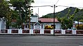
Tagulandang
- Area
- 52.4 km²
- High point
- 784 m
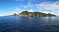
Biaro Island
- Area
- 22.6 km²
- High point
- 372 m
Ruang Island
- Area
- 13.5 km²
- High point
- 725 m
Pulau Kahakitang
- Area
- 8.4 km²
- High point
- 240 m
Pulau Bukide
- Area
- 5.4 km²
- High point
- 233 m
Pulau Kalama
- Area
- 5.1 km²
- High point
- 352 m
Pulau Nusa
- Area
- 4.6 km²
- High point
- 281 m
Pulau Batunderang
- Area
- 3.7 km²
- High point
- 172 m
Pulau Mahumu
- Area
- 3.6 km²
- High point
- 235 m
Pulau Beeng Darat
- Area
- 3 km²
- High point
- 130 m
Pulau Para
- Area
- 2.9 km²
- High point
- 219 m
Pulau Tehang
- Area
- 1.5 km²
- High point
- 213 m
Marore Island
- Area
- 1.5 km²
- High point
- 117 m
Kawaluso Island
- Area
- 1.3 km²
- High point
- 256 m
Pulau Mahengetang
- Area
- 0.76 km²
- High point
- 127 m
Kemboling Island
- Area
- 0.63 km²
- High point
- 91 m
Kawio Island
- Area
- 0.62 km²
- High point
- 54 m
Pulau Bebalang
- Area
- 0.59 km²
- High point
- 110 m
Pulau Batuwingkung
- Area
- 0.57 km²
- High point
- 112 m
Pulau Lenggis
- Area
- 0.53 km²
- High point
- 97 m
Lipang Island
- Area
- 0.5 km²
- High point
- 129 m
Pulau Matutuang
- Area
- 0.47 km²
- High point
- 46 m
Pulau Salangkere
- Area
- 0.44 km²
- High point
- 86 m
Pulau Beeng Laut
- Area
- 0.43 km²
- High point
- 77 m
Pulau Seha Kolabo
- Area
- 0.38 km²
- High point
- 60 m
Pulau Siha
- Area
- 0.29 km²
- High point
- 94 m
Mamanu Island
- Area
- 0.14 km²
- High point
- 42 m
Pulau Nitu
- Area
- 0.14 km²
- High point
- 45 m
Salehe Island
- Area
- 0.11 km²
- High point
- 28 m
Rocks & skerries
On the chart above, at its closest zooms.
Listing 31 of 210; the rest are on the chart.
Figures
Comparative heights
- Siau: 1,827 m
- Sangihe: 1,320 m
- Tagulandang: 784 m
- Ruang: 725 m
- Biaro: 372 m
- Pulau Kalama: 352 m
- Pulau Nusa: 281 m
- Kawaluso: 256 m
- Pulau Kahakitang: 240 m
- Pulau Mahumu: 235 m
- Pulau Bukide: 233 m
- Pulau Para: 219 m
- Pulau Tehang: 213 m
- Pulau Batunderang: 172 m
To the same scale
Islands by area
| Sangihe Island | 550 km² |
| Siau Island | 114 km² |
| Tagulandang | 52.4 km² |
| Biaro Island | 22.6 km² |
| Ruang Island | 13.5 km² |
| Pulau Kahakitang | 8.4 km² |
| Pulau Bukide | 5.4 km² |
| Pulau Kalama | 5.1 km² |
| Pulau Nusa | 4.6 km² |
| Pulau Batunderang | 3.7 km² |
| Pulau Mahumu | 3.6 km² |
| Pulau Beeng Darat | 3 km² |
| Pulau Para | 2.9 km² |
| Pulau Tehang | 1.5 km² |
| Marore Island | 1.5 km² |
| Kawaluso Island | 1.3 km² |
| Pulau Mahengetang | 0.76 km² |
| Kemboling Island | 0.63 km² |
| Kawio Island | 0.62 km² |
| Pulau Bebalang | 0.59 km² |
| Pulau Batuwingkung | 0.57 km² |
| Pulau Lenggis | 0.53 km² |
| Lipang Island | 0.5 km² |
| Pulau Matutuang | 0.47 km² |
| Pulau Salangkere | 0.44 km² |
| Pulau Beeng Laut | 0.43 km² |
| Pulau Seha Kolabo | 0.38 km² |
| Pulau Siha | 0.29 km² |
| Mamanu Island | 0.14 km² |
| Pulau Nitu | 0.14 km² |
| Salehe Island | 0.11 km² |
Groups within
Overlapping groups
Photographs

Sangihe menyediakan rumah bagi makhluk di dalamnya. Tak terkecuali satwa dan tumbuhan yang ada di darat dan laut. Di Darat, Sahendaruman menjadi rumah dan benteng terakhir keragaman hayati terestrial yang terancam punah.

Pemandangan Teluk Tahuna dari Hutan Lindung Sahendaruman II. Tahuna merupakan ibu kota Kabupaten Kep. Sangihe

Gipfel des Vulkans Karangetang auf der Indonesischen Insel Siau - aufgenommen a. 15. April 2009


Keindahan matahari terbit di Puncak Gunung Awu.

Bentuk kubur Islam tua di pulau Sangihe

Bentuk kubur Islam tua di pulau Sangihe

Pulau Sangihe, Kab. Sangihe, Sulut

Les corvettes sur les rochers de l'île Sanguir. Atlas pittoresque, planche 105

Marore Beach

Dari laut kita hidup

Pelangi setelah Badai
Sources
Facts
Photographs
- Sisi barat bentang alam sahendaruman. Ganjaraprianto / CC BY-SA 4.0
- Teluk Tahuna. R.Rahasia / CC BY-SA 4.0
- Karangetan-April2009-705. Funnybubbles / CC BY-SA 3.0
- Lembah habitat seriwang sangihe. Ganjaraprianto / CC BY-SA 4.0
- Puncak Gunung Awu. R.Rahasia / CC BY-SA 4.0
- Kubur tua Islam TUA (1) 01. Alffian / CC0
- Kubur tua Islam TUA (1) 03. Alffian / CC0
- Pulau Sangihe, Kab. Sangihe, Sulut - panoramio. Mujiono Leo / CC BY-SA 3.0
- Atlas pittoresque pl 105. Louis Le Breton / Public domain
- Marore Beach - panoramio. Christian Setiawan / CC BY-SA 3.0
- Lautan Marore. Mardiansyah Nugraha / CC BY-SA 4.0
- Pelangi Pelabuhan Marore. Mardiansyah Nugraha / CC BY-SA 4.0