Mediterranean SeaFrance
43°31′N 7°03′E
Lérins Islands
Îles de Lérins
The Lérins Islands are a group of five Mediterranean islands off the French Riviera, in Cannes. The two largest islands in this group are Île Sainte-Marguerite and Île Saint-Honorat. The smaller Îlot Saint-Ferréol, Îlot de la Tradelière and Îlot de l'Ilon (also called l'Îlot) are uninhabited.

Chart
Overview
The Lérins Islands are a group of five Mediterranean islands off the French Riviera, in Cannes. The two largest islands in this group are Île Sainte-Marguerite and Île Saint-Honorat. The smaller Îlot Saint-Ferréol, Îlot de la Tradelière and Îlot de l'Ilon (also called l'Îlot) are uninhabited. Administratively, the islands belong to the commune of Cannes. The islands are first known to have been inhabited during Roman times. The Île de Saint-Honorat bears the name of the founder of the monastery of Lérins, Saint Honoratus. It was founded around the year 410. According to tradition, Saint Patrick, patron of Ireland, studied there in the fifth century. Around 500, the community was led by Porcarius I. Around 732, the Abbot Porcarius II was killed during a Saracen raid. In 1047 the islands were raided by pirates from Andalusia. Thereafter, a fortified monastery was built between the eleventh and fourteenth centuries. The monastic community today lives in a monastery built during the nineteenth century. The Île Sainte-Marguerite held a fortress where the Man in the Iron Mask was held captive for a time. During the Thirty Years' War, Spain was in possession of the islands between September 1635 and May 1637, and built or rebuilt four fortresses on Santa Margarita. In 1707 the Lérins were occupied by the English navy, under the command of Sir Cloudesley Shovell. This was done in order to block the military port of Toulon to help the army of Victor Amadeus II Duke of Savoy and his cousin Eugene besiege that city. Under the French Revolution, the Île Sainte-Marguerite and the Île Saint-Honorat were renamed the Île Marat and the Île Lepeletier, after secular martyrs.
From Wikipedia, CC BY-SA 4.0
Census, cataloged
- Major islands2
- Minor islands0
- Islets4
- Rocks & skerries7
Major islands
Île Sainte-Marguerite
- Area
- 1.8 km²
- High point
- 44 m
Île Sainte-Marguerite (pronounced [il sɛ̃tmaʁɡ(ə)ʁit]; French: Île Sainte-Marguerite, transl. Saint Margaret Island) is the largest of the Lérins Islands, about half a mile offshore from the French Riviera city of Cannes, situated in the Bay of Cannes. 59 miles) across (north to south).
Île Saint-Honorat
- Area
- 0.42 km²
- High point
- 17 m
Île Saint-Honorat (French pronunciation: [il sɛ̃tɔnɔʁa]) is the second-largest of the Lérins Islands, about 1.6 kilometres (1 mi) off shore from the French Riviera city of Cannes. The island is approximately 1.5 kilometres (0.93 mi) in length (east to west) and 400 metres (1,300 ft) wide.

Islets
- îlot de la Tradelière2 m · 0.02 km²
- îlot Saint-Ferréol2 m · 1 ha
- Unnamed island0.2 ha
- L'Îlot0.2 ha
Rocks & skerries
- Unnamed island<0.1 ha
- Unnamed island<0.1 ha
- Unnamed island<0.1 ha
- Unnamed island<0.1 ha
- Unnamed island<0.1 ha
- Unnamed island<0.1 ha
- Tourelle des Moines<0.1 ha
Figures
Comparative heights
- Île Sainte-Marguerite: 44 m
- Île Saint-Honorat: 17 m
- îlot de la Tradelière: 2 m
- îlot Saint-Ferréol: 2 m
To the same scale
Islands by area
| Île Sainte-Marguerite | 1.8 km² |
| Île Saint-Honorat | 0.42 km² |
| îlot de la Tradelière | 0.02 km² |
| îlot Saint-Ferréol | 1 ha |
| Unnamed island | 0.2 ha |
| L'Îlot | 0.2 ha |
| Unnamed island | <0.1 ha |
| Unnamed island | <0.1 ha |
| Unnamed island | <0.1 ha |
| Unnamed island | <0.1 ha |
| Unnamed island | <0.1 ha |
| Unnamed island | <0.1 ha |
| Tourelle des Moines | <0.1 ha |
Photographs

Aerial view of Îles de Lérins
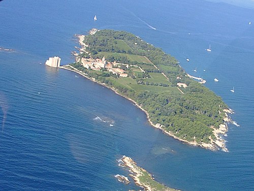
Ile de Saint-Honorat vue d'avion


Sight, from the heights of Théoule-sur-Mer, of the îles du Lérins islands, île Sainte-Marguerite and île Saint-Honorat, with the cap d'Antibes cap on the left border, near Cannes in Alpes-Maritimes, France.

Sight, from the fortified monastery of Lérins abbey, of the southern coast of the île Saint-Honorat island, with the îlot Saint-Ferréol at the background, in the bay of Cannes, Alpes-Maritimes, France.

Lérins Islands, FRANCE

Sight of the îlot Saint-Ferréol island, seen from the île Saint-Honorat island, in the bay of Cannes, Alpes-Maritimes, France.

Mons(Var) : Panorama on Ils de Lerins

Aerial view of Îles de Lérins

Sight of the Îlot tiny island, seen from the southern coast of the île Saint-Honorat island, in the bay of Cannes, in Alpes-Maritimes, France.

Леринские острова и массив Эстерель

Iles de Lérins vues de la plage de Gardanne
Sources
Facts
Photographs
- Aerial view of Îles de Lérins (cropped). Olivier Cleynen / CC BY 4.0
- Ile Ste Honorat. Jeje42 / CC BY-SA 3.0
- Les Isles de Lerins, Cannes, Riviera-LCCN2001699288. Photochrom Print Collection / Public domain
- Îles de Lérins depuis Théoule (2014). Florian Pépellin / CC BY-SA 3.0
- Sud-est île Saint-Honorat (2014). Florian Pépellin / CC BY-SA 3.0
- Ste Marguerite 04. Christophe.Finot / CC BY-SA 2.5
- Îlot Saint-Férréol (2014). Florian Pépellin / CC BY-SA 3.0
- Mons Lerins. This illustration was made by (User:Royonx) and released under the license(s) stated above. You are free to use it for a / CC BY-SA 3.0
- Aerial view of Îles de Lérins. Olivier Cleynen / CC BY 4.0
- L'îlot (îles de Lérins, 2014). Florian Pépellin / CC BY-SA 3.0
- Îles de Lérins et massif de l'Esterel. И. Максим Массалитин / CC BY-SA 2.0
- Iles de Lérins vues de la plage de Gardanne (5546496805). Иерей Максим Массалитин from Rabat, Maroc / CC BY-SA 2.0