Indian OceanSeychelles
4°31′S 55°35′E
Granitic Seychelles
Part of Inner Islands
The Granitic Seychelles are the islands in Seychelles which lie in central position on the Seychelles Bank and are composed of granite rock. They make up the majority of the Inner Islands, which in addition include the coral islands along of the rim of the Seychelles Bank, namely Bird Island and Denis Island.

Chart
Overview
The Granitic Seychelles are the islands in Seychelles which lie in central position on the Seychelles Bank and are composed of granite rock. They make up the majority of the Inner Islands, which in addition include the coral islands along of the rim of the Seychelles Bank, namely Bird Island and Denis Island. The Granitic Seychelles contrast with the Coralline Seychelles or the Outer Islands, several island groups made up of low coral islands with dry, infertile soils. The Granitic Seychelles are home to tropical moist forests, with several endemic species, including the coco de mer (Lodoicea maldivica), and the jellyfish tree (Medusagyne oppositifolia).
From Wikipedia, CC BY-SA 4.0
Census, cataloged
- Major islands3
- Minor islands26
- Islets35
- Rocks & skerries32
Major islands
Mahé
- Area
- 155 km²
- High point
- 905 m
7 sq mi), lying in the northeast of the Seychellois nation in the Somali Sea part of the Indian Ocean. The population of Mahé was 77,000, as of the 2010 census. It contains the capital city of Victoria and accommodates 86% of the country's total population.
Praslin
- Area
- 38.2 km²
- High point
- 350 m
5 km2) of the Inner Seychelles, lying 44 km (27 mi) northeast of Mahé. Praslin has a population of around 7,533 people and comprises two administrative districts: Baie Sainte Anne and Grand' Anse. The main settlements are the Baie Ste Anne, Anse Volbert and Grand' Anse.
Silhouette Island
- Area
- 20 km²
- High point
- 725 m
Silhouette Island lies 20 km (12 mi) northwest of Mahé in the Seychelles. It is the third largest granitic island in the Seychelles. 1 km2 and has a population of 200, mostly workers on the island. The main settlement is La Passe, where Hilton Hotel is located.

Minor islands

La Digue
- Area
- 10 km²
- High point
- 333 m

Curieuse Island
- Area
- 2.9 km²
- High point
- 172 m

Félicité Island
- Area
- 2.7 km²
- High point
- 207 m

Ste. Anne Island
- Area
- 2.3 km²
- High point
- 253 m

Frégate Island
- Area
- 2.1 km²
- High point
- 125 m

North Island
- Area
- 2 km²
- High point
- 180 m

Cerf Island
- Area
- 1.3 km²
- High point
- 107 m
Perseverance Island
- Area
- 0.96 km²
- High point
- 17 m

Marianne Island
- Area
- 0.92 km²
- High point
- 113 m

Grande Soeur
- Area
- 0.76 km²
- High point
- 86 m

Thérèse Island
- Area
- 0.76 km²
- High point
- 158 m
Aride Island
- Area
- 0.69 km²
- High point
- 135 m

Conception Island, Seychelles
- Area
- 0.6 km²
- High point
- 133 m
Unnamed island
- Area
- 0.59 km²
- High point
- 14 m
Unnamed island
- Area
- 0.58 km²
- High point
- 14 m
Eden Island
- Area
- 0.46 km²
- High point
- 13 m
Unnamed island
- Area
- 0.4 km²
- High point
- 15 m
Cousin Island
- Area
- 0.36 km²
- High point
- 58 m

Petite Soeur
- Area
- 0.34 km²
- High point
- 103 m
Unnamed island
- Area
- 0.29 km²
- High point
- 14 m

Cousine Island
- Area
- 0.28 km²
- High point
- 69 m

Long Island
- Area
- 0.22 km²
- High point
- 72 m

Round Island, Praslin
- Area
- 0.2 km²
- High point
- 75 m
Romainville Island
- Area
- 0.19 km²
- High point
- 13 m
Île aux Récifs
- Area
- 0.19 km²
- High point
- 45 m

Anonyme Island
- Area
- 0.1 km²
- High point
- 39 m
Islets
- Moyenne Island53 m · 0.09 km²
- Mamelles Island34 m · 0.05 km²
- Vache Island51 m · 0.05 km²
- L'Islette6 m · 0.03 km²
- Round Island, Mahé26 m · 0.03 km²
- Unnamed island26 m · 0.02 km²
- Cachée Island21 m · 0.02 km²
- Round Island, Praslin25 m · 0.02 km²
- Coco Island10 m · 0.02 km²
- Unnamed island3 m · 0.01 km²
- Rat Island9 m · 0.9 ha
- Unnamed island10 m · 0.9 ha
Rocks & skerries
- Unnamed island<0.1 ha
- Unnamed island<0.1 ha
- Unnamed island<0.1 ha
- Unnamed island<0.1 ha
- Unnamed island<0.1 ha
- Unnamed island<0.1 ha
- Unnamed island<0.1 ha
- Unnamed island<0.1 ha
- Unnamed island<0.1 ha
- Unnamed island<0.1 ha
- Unnamed island<0.1 ha
- Unnamed island<0.1 ha
Figures
Comparative heights
To the same scale
Islands by area
| Mahé | 155 km² |
| Praslin | 38.2 km² |
| Silhouette Island | 20 km² |
| La Digue | 10 km² |
| Curieuse Island | 2.9 km² |
| Félicité Island | 2.7 km² |
| Ste. Anne Island | 2.3 km² |
| Frégate Island | 2.1 km² |
| North Island | 2 km² |
| Cerf Island | 1.3 km² |
| Perseverance Island | 0.96 km² |
| Marianne Island | 0.92 km² |
| Grande Soeur | 0.76 km² |
| Thérèse Island | 0.76 km² |
| Aride Island | 0.69 km² |
| Conception Island, Seychelles | 0.6 km² |
| Unnamed island | 0.59 km² |
| Unnamed island | 0.58 km² |
| Eden Island | 0.46 km² |
| Unnamed island | 0.4 km² |
| Cousin Island | 0.36 km² |
| Petite Soeur | 0.34 km² |
| Unnamed island | 0.29 km² |
| Cousine Island | 0.28 km² |
| Long Island | 0.22 km² |
| Round Island, Praslin | 0.2 km² |
| Romainville Island | 0.19 km² |
| Île aux Récifs | 0.19 km² |
| Anonyme Island | 0.1 km² |
| Moyenne Island | 0.09 km² |
| Mamelles Island | 0.05 km² |
| Vache Island | 0.05 km² |
| L'Islette | 0.03 km² |
| Round Island, Mahé | 0.03 km² |
| Unnamed island | 0.02 km² |
| Cachée Island | 0.02 km² |
| Round Island, Praslin | 0.02 km² |
| Coco Island | 0.02 km² |
| Unnamed island | 0.01 km² |
| Rat Island | 0.9 ha |
| Unnamed island | 0.9 ha |
| Unnamed island | 0.7 ha |
| Unnamed island | 0.6 ha |
| St. Pierre Island, Praslin | 0.6 ha |
| Unnamed island | 0.5 ha |
| Unnamed island | 0.4 ha |
| Unnamed island | 0.3 ha |
| Unnamed island | 0.3 ha |
| Unnamed island | 0.3 ha |
| Unnamed island | 0.3 ha |
| Unnamed island | 0.3 ha |
| Unnamed island | 0.2 ha |
| Unnamed island | 0.2 ha |
| Unnamed island | 0.2 ha |
| Unnamed island | 0.2 ha |
| Unnamed island | 0.2 ha |
| Unnamed island | 0.1 ha |
| Unnamed island | 0.1 ha |
| Unnamed island | 0.1 ha |
| Unnamed island | 0.1 ha |
| Unnamed island | 0.1 ha |
| Unnamed island | 0.1 ha |
| Unnamed island | 0.1 ha |
| Unnamed island | 0.1 ha |
| Unnamed island | <0.1 ha |
| Unnamed island | <0.1 ha |
| Unnamed island | <0.1 ha |
| Unnamed island | <0.1 ha |
| Unnamed island | <0.1 ha |
| Unnamed island | <0.1 ha |
| Unnamed island | <0.1 ha |
| Unnamed island | <0.1 ha |
| Unnamed island | <0.1 ha |
| Unnamed island | <0.1 ha |
| Unnamed island | <0.1 ha |
| Unnamed island | <0.1 ha |
| Unnamed island | <0.1 ha |
| Unnamed island | <0.1 ha |
| Unnamed island | <0.1 ha |
| Unnamed island | <0.1 ha |
| Unnamed island | <0.1 ha |
| Unnamed island | <0.1 ha |
| Unnamed island | <0.1 ha |
| Unnamed island | <0.1 ha |
| Unnamed island | <0.1 ha |
| Unnamed island | <0.1 ha |
| Unnamed island | <0.1 ha |
| Unnamed island | <0.1 ha |
| Unnamed island | <0.1 ha |
| Unnamed island | <0.1 ha |
| Unnamed island | <0.1 ha |
| Unnamed island | <0.1 ha |
| Unnamed island | <0.1 ha |
| Unnamed island | <0.1 ha |
| Unnamed island | <0.1 ha |
| Unnamed island | <0.1 ha |
Groups within
Photographs

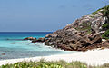
The spectacular beach of Anse Lazio on the island of Praslin, Seychelles

The small granitic island of Chauve Souris, just off the larger island Praslin.

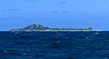
Remote view from Beau Vallon to Silhouette Island, Seychelles
Sources
Facts
Photographs
- Anse Lazio-Praslin-Seychellen. Tobias Alt, Tobi 87 / CC BY-SA 4.0
- La Chauve Souris off Praslin. Bjørn Christian Tørrissen / CC BY-SA 4.0
- Silhouette Island remote view asv2024-10. A.Savin / FAL
- WV banner Praslin Ile St Pierre. Marion Schneider & Christoph Aistleitner / CC0