Erebus Bay
77°43′S 166°12′E
Dellbridge Islands
Part of Ross Archipelago
Erebus Bay (77°44′S 166°31′E) is a bay about 13 nautical miles (24 km; 15 mi) wide between Cape Evans and Hut Point Peninsula, on the west side of Ross Island, Antarctica.

Chart
Overview
Erebus Bay (77°44′S 166°31′E) is a bay about 13 nautical miles (24 km; 15 mi) wide between Cape Evans and Hut Point Peninsula, on the west side of Ross Island, Antarctica.
From Wikipedia, CC BY-SA 4.0
Census, cataloged
- Major islands2
- Minor islands0
- Islets2
- Rocks & skerries0
Major islands
Tent Island
- Area
- 1 km²
- High point
- 133 m
Erebus Bay (77°44′S 166°31′E) is a bay about 13 nautical miles (24 km; 15 mi) wide between Cape Evans and Hut Point Peninsula, on the west side of Ross Island, Antarctica.
Inaccessible Island
- Area
- 0.56 km²
- High point
- 157 m
Erebus Bay (77°44′S 166°31′E) is a bay about 13 nautical miles (24 km; 15 mi) wide between Cape Evans and Hut Point Peninsula, on the west side of Ross Island, Antarctica.
Islets
- Big Razorback Island59 m · 0.09 km²
- Little Razorback Island23 m · 0.8 ha
Figures
Comparative heights
- Inaccessible: 157 m
- Tent: 133 m
- Big Razorback: 59 m
- Little Razorback: 23 m
To the same scale
Islands by area
| Tent Island | 1 km² |
| Inaccessible Island | 0.56 km² |
| Big Razorback Island | 0.09 km² |
| Little Razorback Island | 0.8 ha |
Groups within
Photographs


Big Razorback Island under Clouds

An aerial view of Little Razorback Island surrounded by late season annual sea ice. The leeward side of the island is to the left. A few Weddell seals can be seen on the ice near the island.
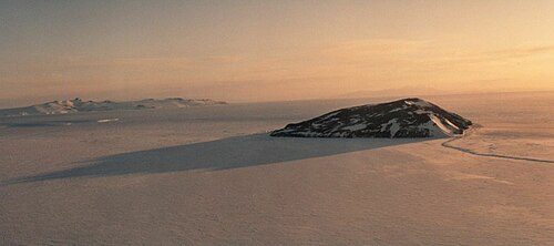
Tent Island, Erebus Bay, Ross Archipelago, Antarctica.

Inacessible Island, southwest of Cape Evans, Antarctica

satellite image of Dellbridge Islands, Erebus Bay, Ross Sea, Antarctica (part of NASA Image aster_erebus_30nov01_15m.jpg) some geographic names added by uploader

Google Earth screen capture showing the location of Scott's Hut, Antarctica. Shown here with the red dot. USGS created image, as the legend at the bottom shows.

Scott's last expedition /
Sources
Facts
Photographs
- Erebus Ice Tongue - Antarctica. NSF/Josh Landis, employee 1999-2001 / Public domain
- Big Razorback Island under Clouds. Alan Light / CC BY 2.0
- Little Razorback Island 2019. Elaine Hood, NSF / Public domain
- Tent island île ross mcmurdo. P. Bond / Public domain
- Inaccessible Island, Antarctica. Ketiltrout / CC BY-SA 4.0
- Dellbridge Islands SAT. NASA / Public domain
- USGS Image of Scott's Hut Antarctica. USGS / Public domain
- Scott's last expedition BHL48065631. Huxley, Leonard; Scott, Robert Falcon / Public domain